METAR & TAF KPRN
Current METAR
Observed 17:00Z
KPRN 261700Z AUTO 32006KT 10SM FEW075 30/23 A3004 RMK AO2 SLP119 T03000228
- Wind
- 320° @ 6 kt
- Visibility
- 10 SM
- Temp / Dew
- 30°C / 23°C
- Altimeter
- 30.04 inHg
- Clouds
- FEW
- Density alt
- 2,211 ft
- Ceiling
- Unlimited
- Rules
- VFR
Airport info & contacts
Manager on record, flight service, ARTCC, attendance schedule and pattern altitude — published by the FAA and refreshed every 28 days.
Location
- From city
- 2 NM NE
- VFR sectional
- NEW ORLEANS
- ARTCC
- ZTL · ATLANTA
- NOTAM facility
- ANB (NOTAM-D)
Airport manager
- Name
- BRUCE D. EDWARDS
- Phone
- 334-382-8166
- Address
- 117 COMMANCHE DRIVE, GREENVILLE AL 36037
Flight service · Hours
- FSS ANB
- ANNISTON1-800-WX-BRIEF
- Attendance
- MON-FRI · 0800-1700
- SAT-SUN · Unattended
Frequencies
Tap any row to copy the frequency to your clipboard.
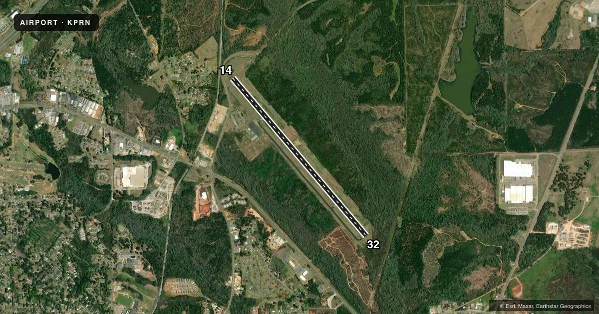
Runways & pattern
Full pagePattern entry · RWY 32
LEFT TRAFFICRunway end performance
| End | TORA | TODA | ASDA | LDA | VGSI | Approach lights | Obstruction |
|---|---|---|---|---|---|---|---|
| 14 | 5,200' | 5,500' | 5,200' | 5,200' | PAPI 2-box left(3°) | — | 13', tree, 305' from thr, 90' R of cntrln, slope 8 |
| 32 | 5,500' | 5,500' | 5,500' | 5,200' | PAPI 2-box left(3°) | — | — |
Declared distances in feet. TORA = takeoff run available, TODA = takeoff distance, ASDA = accelerate-stop, LDA = landing distance.
Airport sketch
Runways drawn to scale from FAA survey coordinates, rendered over satellite imagery. Not for navigation.
Approaches & charts
Services on the field
Fuel grades, oxygen, maintenance, ramp storage and lighting — as declared to the FAA by the airport operator.
Fuel & services
- Fuel
- 100LL
- Oxygen (bottled)
- Not available
- Oxygen (bulk)
- Not available
- Airframe repair
- Not available
- Power plant repair
- Not available
Ramp & ground
- Transient storage
- Tie-down
- Hangar
- Landing fee
- No fee published
- Customs
- Not available
- Lighting schedule
- SEE RMK
- Beacon schedule
- SS-SR
- Beacon
- White / Green (civil land)(WG)
- Wind indicator
- Lighted
- Segmented circle
- Yes
Fuel & FBOs
Cheapest 100LL and Jet A on the field and nearby. Always confirm with the FBO before taxi.
Airport notes
Surface conditions, obstructions, local procedures, lighting outages and other notes published with each FAA cycle.
General notes
- FOR CD CTC ATLANTA ARTCC AT 770-210-7692.
Lighting notes
- ACTVT REIL RWY 14 & 32; PAPI RWY 14 & 32; MIRL RWY 14/32 - CTAF.
Fuel notes
- 100LLSVC CHARGE FOR FUEL AFT HRS CALL 334-300-0032.
Approach & departure obstructions
- 14MARKINGS FADED AND OBSCURED BY ALGAE
- 32MARKINGS FADED AND OBSCURED BY ALGAE
- 32CLNC SLOPE 37:1 FM DSPLCD THR.
Other notes
- ARPT BUILT BEFORE FAA ACT
- TPA: 1000 FT AGL CAT A AND B ACFT, 1500 FT AGL CAT C ACFT.
VFR map & nearby airports
VFR sectional. Tap any ICAO chip to open that airport.
Key facts · KPRN
Answer card- ICAO
- KPRN
- Name
- MAC CRENSHAW MEML
- Location
- GREENVILLE, ALABAMA
- Elevation
- 451.4 ft MSL
- Traffic pattern altitude
- 1,451.4 ft MSL (1,000 AGL)
- Control tower
- Non-towered (use CTAF)
- Total runways
- 1
- Longest runway
- 14/32 · 5,501 ft
- Published ILS approaches
- 0
- Published frequencies
- 2
- Magnetic variation
- 2°
- Current flight rules
- VFR
- Current wind
- 320° at 6 kt
- Favored runway now
- RWY 32
Mac Crenshaw Meml Airport sits in Greenville, Alabama. Field elevation is 451.4 ft MSL. The airport has one runway, 14/32, which is 5,501 ft long and paved with asphalt. There is no control tower. CTAF and UNICOM are both 122.8. No ILS approaches are published here.
The published pattern altitude is 1,000 ft AGL for category A and B aircraft. Category C uses 1,500 ft AGL. The field is served by the on-field Mac Crenshaw Memorial Airport FBO. It carries AVGAS 100LL. Call ahead if you need fuel after hours. A service charge applies. The airport also notes that runway 14 and runway 32 have runway end identifier lights, PAPI and medium intensity runway lighting.
A few operational details matter here. Runway 32 has a displaced threshold with a 37 to 1 clearance slope. Markings on both runway ends are reported as faded and obscured by algae. Use the common traffic advisory frequency for traffic calls. For clearance delivery, contact Atlanta ARTCC. If you need current noise or local operating restrictions, check the current FAA Chart Supplement or call the airport operator before you go.