METAR & TAF 04A
04A does not publish a METAR.
Showing the nearest reporting station: KTOI (TROY MUNI AT N KENNETH CAMPBELL FLD) · 14.7 NM away. Conditions at 04A may differ.
METAR · KTOI
Observed 10:53Z
KTOI 271053Z AUTO 21003KT 6SM BR CLR 23/23 A2994 RMK AO2 SLP131 T02330228 PNO $
- Wind
- 210° @ 3 kt
- Visibility
- 6 SM
- Temp / Dew
- 23°C / 23°C
- Altimeter
- 29.94 inHg
- Clouds
- CLR
- Density alt
- 1,310 ft
- Ceiling
- Unlimited
- Rules
- VFR
Airport info & contacts
Manager on record, flight service, ARTCC, attendance schedule and pattern altitude — published by the FAA and refreshed every 28 days.
Location
- From city
- 2 NM N
- VFR sectional
- NEW ORLEANS
- ARTCC
- ZJX · JACKSONVILLE
- NOTAM facility
- ANB (NOTAM-D)
Airport manager
- Name
- STEVE DEFEE
- Phone
- 334-508-1013
- Address
- PO BOX 249, LUVERNE AL 36049
Flight service · Hours
- FSS ANB
- ANNISTON1-800-WX-BRIEF
- Attendance
- UNATTENDED
Frequencies
Tap any row to copy the frequency to your clipboard.
Runways & pattern
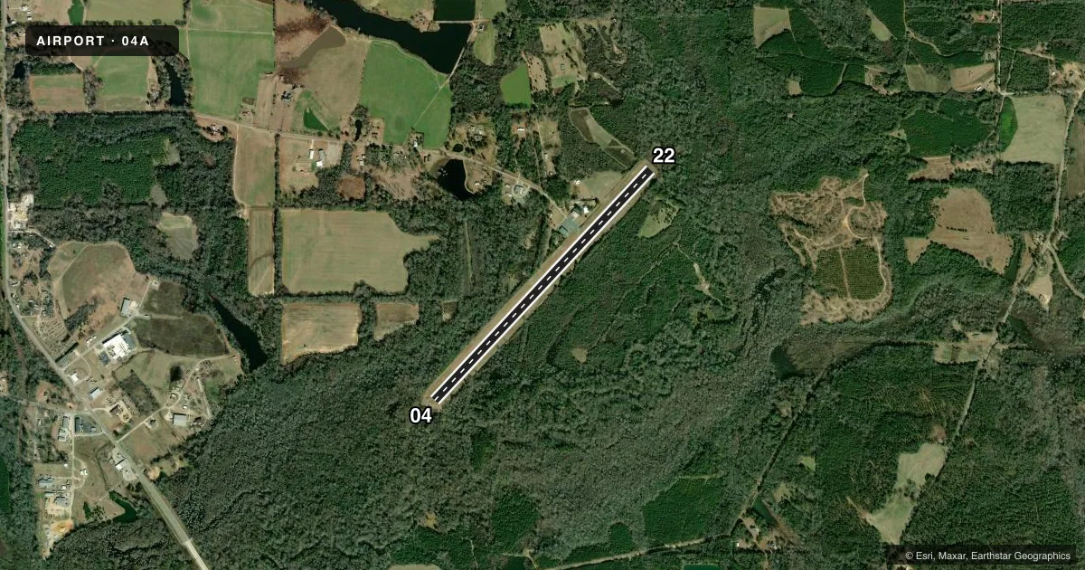
Full pagePattern entry · RWY 22
LEFT TRAFFICAirport sketch
Runways drawn to scale from FAA survey coordinates, rendered over satellite imagery. Not for navigation.
Approaches & charts
Services on the field
Fuel grades, oxygen, maintenance, ramp storage and lighting — as declared to the FAA by the airport operator.
Fuel & services
- Fuel
- 100LL
- Oxygen (bottled)
- Not available
- Oxygen (bulk)
- Not available
Ramp & ground
- Transient storage
- Tie-down
- Landing fee
- No fee published
- Customs
- Not available
- Lighting schedule
- SEE RMK
- Beacon schedule
- SS-SR
- Beacon
- White / Green (civil land)(WG)
- Wind indicator
- Yes
- Segmented circle
- No
Fuel & FBOs
Cheapest 100LL and Jet A on the field and nearby. Always confirm with the FBO before taxi.
Airport notes
Surface conditions, obstructions, local procedures, lighting outages and other notes published with each FAA cycle.
General notes
- FOR CD CTC CAIRNS APCH. WHEN CAIRNS APCH CLSD, FOR CD CTC JACKSONVILLE ARTCC AT 904-845-1592.
Lighting notes
- ACTVT LIRL RWY 04/22 - CTAF.
Fuel notes
- 100LLSELF-SERVE
Runway surface & condition
- 04/22NSTD LIRL; FIRST 750 FT RWY 04 & FIRST 875 FT OF RWY 22 UNLGTD.
Approach & departure obstructions
- 22480 FT MSL WATER TWR S OF RWY 22.
- 04RWY 04 APCH RATIO 13:1 FROM DSPLCD THLD.
- 22RWY 22 APCH RATIO 15:1 FROM DSPLCD THR.
Other notes
- VFR ONLY.
- 04/22WDSPR CRACKING ON RWY SFC.
VFR map & nearby airports
VFR sectional. Tap any ICAO chip to open that airport.
Key facts · 04A
Answer card- ICAO
- 04A
- Name
- FRANK SIKES
- Location
- LUVERNE, ALABAMA
- Elevation
- 302 ft MSL
- Traffic pattern altitude
- 1,302 ft MSL (1,000 AGL)
- Control tower
- Non-towered (use CTAF)
- Total runways
- 1
- Longest runway
- 04/22 · 4,649 ft
- Published ILS approaches
- 0
- Published frequencies
- 2
- Magnetic variation
- 0°
- Current flight rules
- VFR
- Current wind
- 210° at 3 kt
- Favored runway now
- RWY 22
Frank Sikes Airport sits in Luverne, Alabama. Field elevation is 302 ft MSL. The airport has one runway. Runway 04/22 is 4,649 ft long and asphalt. There is no control tower. No ILS approaches are published, so plan for VFR only. The pattern altitude is not published. Use the standard 1,000 ft AGL pattern for light piston traffic unless the current Chart Supplement says otherwise.
The on-field FBO is Frank Sikes Airport. It carries AVGAS 100LL. Self-serve 100LL is available. The airport uses CTAF 122.8 and UNICOM 122.8. Published remarks note widespread cracking on the runway surface. They also note that the first 750 ft of runway 04 and the first 875 ft of runway 22 are unlighted. Low intensity runway lights are activated on CTAF. That matters if you are planning a night arrival.
This is a VFR-only field. Runway 22 has a 480 ft MSL water tower south of the runway. The published approach ratios also show displaced threshold considerations on both ends. If you are new to the airport, brief the runway condition before arrival and check current lighting status. For clearance delivery, contact Cairns Approach. When Cairns Approach is closed, contact Jacksonville ARTCC.