METAR & TAF 71J
71J does not publish a METAR.
Showing the nearest reporting station: KDHN (DOTHAN RGNL) · 11.0 NM away. Conditions at 71J may differ.
METAR · KDHN
Observed 16:53Z
KDHN 261653Z 03006KT 10SM BKN100 27/24 A3009 RMK AO1 SLP182 T02720244 $
- Wind
- 030° @ 6 kt
- Visibility
- 10 SM
- Temp / Dew
- 27°C / 24°C
- Altimeter
- 30.09 inHg
- Clouds
- BKN
- Density alt
- 1,673 ft
- Ceiling
- 10,000 ft AGL
- Rules
- VFR
Airport info & contacts
Manager on record, flight service, ARTCC, attendance schedule and pattern altitude — published by the FAA and refreshed every 28 days.
Location
- From city
- 2 NM SE
- VFR sectional
- NEW ORLEANS
- ARTCC
- ZJX · JACKSONVILLE
- NOTAM facility
- ANB (NOTAM-D)
Airport manager
- Name
- DENISE ELLIS
- Phone
- 334-445-5045
- Address
- 3269 HWY 231 S, OZARK AL 36360
Flight service · Hours
- FSS ANB
- ANNISTON1-800-WX-BRIEF
- Attendance
- MON-FRI · 0800-1700
Frequencies
Tap any row to copy the frequency to your clipboard.
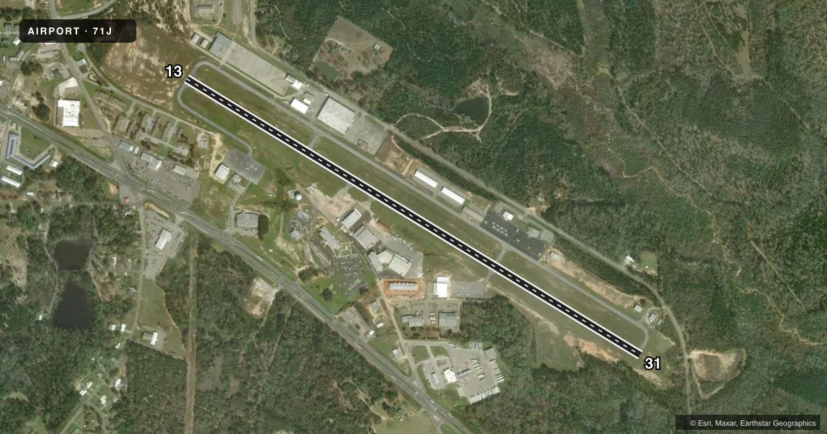
Runways & pattern
Full pagePattern entry · RWY 31
LEFT TRAFFICRunway end performance
| End | TORA | TODA | ASDA | LDA | VGSI | Approach lights | Obstruction |
|---|---|---|---|---|---|---|---|
| 13 | — | — | — | — | PAPI 4-box right(3.6°) | — | 45', tree, 615' from thr, 615' R of cntrln, slope 9 |
| 31 | — | — | — | — | PAPI 4-box left(3°) | — | 19', tree, 247' from thr, 163' R of cntrln, slope 2 |
Declared distances in feet. TORA = takeoff run available, TODA = takeoff distance, ASDA = accelerate-stop, LDA = landing distance.
Airport sketch
Runways drawn to scale from FAA survey coordinates, rendered over satellite imagery. Not for navigation.
Approaches & charts
Services on the field
Fuel grades, oxygen, maintenance, ramp storage and lighting — as declared to the FAA by the airport operator.
Fuel & services
- Fuel
- 100LLA
- Oxygen (bottled)
- Not available
- Oxygen (bulk)
- Not available
- Airframe repair
- Major
- Power plant repair
- Major
- Other services
- CHTR,INSTR,RNTL
Ramp & ground
- Transient storage
- Tie-down
- Landing fee
- No fee published
- Customs
- Not available
- Lighting schedule
- SEE RMK
- Beacon schedule
- SS-SR
- Beacon
- White / Green (civil land)(WG)
- Wind indicator
- Lighted
- Segmented circle
- Yes
Fuel & FBOs
Cheapest 100LL and Jet A on the field and nearby. Always confirm with the FBO before taxi.
Airport notes
Surface conditions, obstructions, local procedures, lighting outages and other notes published with each FAA cycle.
General notes
- LOW FLYING HOP IN TFC PAT.
- RWY & PARL TWYS CNTRLN SEPN IS 240 FT.
- PILOTS DEPG BLACKWELL VFR TO THE EAST OR NORTH RMN AT 1500 FT MSL OR BLW TIL APRXLY 5 MI FM THE ARPT TO AVOID CONFLICT WITH TFC ON IFR APCH TO THE DOTHAN ARPT.
- FOR CD CTC CAIRNS APCH AT 334-255-8402, WHEN APCH CLSD CTC JACKSONVILLE ARTCC AT 904-845-1592.
- RWY 13/31 CLSD TO HEL RUNNING LDG BY SKID EQUIPPED HEL
Lighting notes
- ACTVT REIL RWY 13 & 31; PAPI RWY 13 & 31; MIRL RWY 13/31 - CTAF.
Fuel notes
- 100LLAVGAS 24 HR CREDIT CARD SVC AVBL.
Approach & departure obstructions
- 13CTLG OBSTN EXCEEDS A 45 DEG SLP.
Other notes
- 1AFT HRS SVC CALL 334-432-0039.
VFR map & nearby airports
VFR sectional. Tap any ICAO chip to open that airport.
Key facts · 71J
Answer card- ICAO
- 71J
- Name
- OZARK/BLACKWELL FLD
- Location
- OZARK, ALABAMA
- Elevation
- 357.9 ft MSL
- Traffic pattern altitude
- 1,357.9 ft MSL (1,000 AGL)
- Control tower
- Non-towered (use CTAF)
- Total runways
- 1
- Longest runway
- 13/31 · 5,152 ft
- Published ILS approaches
- 0
- Published frequencies
- 4
- Magnetic variation
- 4°
- Current flight rules
- VFR
- Current wind
- 030° at 6 kt
- Favored runway now
- RWY 31
Ozark/Blackwell Fld sits in Ozark, Alabama. The field elevation is 357.9 ft MSL. It has one runway, 13/31, which is 5,152 ft long. There is no control tower. Pattern altitude is not published, so light piston pilots should plan on the standard 1,000 ft AGL unless the current Chart Supplement says otherwise.
No ILS approaches are published here. CTAF and UNICOM are both 122.7. Approach and departure service is on 125.4 or 327.125 with Cairns. The on-field FBO is Ozark/Blackwell Field. It carries 100LL and Jet A. After-hours service is available by phone. Avgas 24-hour credit card service is also published.
A few operational items matter here. Low-flying helicopter traffic can be in the pattern. Runway 13/31 is closed to skid-equipped helicopter landings. Pilots departing VFR to the east or north should stay at 1,500 ft MSL or below until about 5 NM from the airport to avoid conflict with IFR traffic into Dothan. Runway 13 has cataloged obstructions that exceed a 45 degree slope. The runway has REILs, PAPI and medium intensity lighting controlled by CTAF. For clearance delivery, contact Cairns Approach. If approach is closed, use Jacksonville ARTCC.