METAR & TAF 14J
14J does not publish a METAR.
Showing the nearest reporting station: KEDN (ENTERPRISE MUNI) · 11.8 NM away. Conditions at 14J may differ.
METAR · KEDN
Observed 03:35Z
KEDN 270335Z AUTO 00000KT 10SM CLR 26/24 A2995 RMK AO1 T02560241
- Wind
- 000° @ 0 kt
- Visibility
- 10 SM
- Temp / Dew
- 26°C / 24°C
- Altimeter
- 29.95 inHg
- Clouds
- CLR
- Density alt
- 1,603 ft
- Ceiling
- Unlimited
- Rules
- VFR
Airport info & contacts
Manager on record, flight service, ARTCC, attendance schedule and pattern altitude — published by the FAA and refreshed every 28 days.
Location
- From city
- 2 NM W
- VFR sectional
- NEW ORLEANS
- ARTCC
- ZJX · JACKSONVILLE
- NOTAM facility
- ANB (NOTAM-D)
Airport manager
- Name
- JACKIE WINDHAM
- Phone
- 334-897-6979
- Address
- PO BOX 315, ELBA AL 36323
Flight service · Hours
- FSS ANB
- ANNISTON1-800-WX-BRIEF
- Attendance
- Unattended
Frequencies
Tap any row to copy the frequency to your clipboard.
Runways & pattern
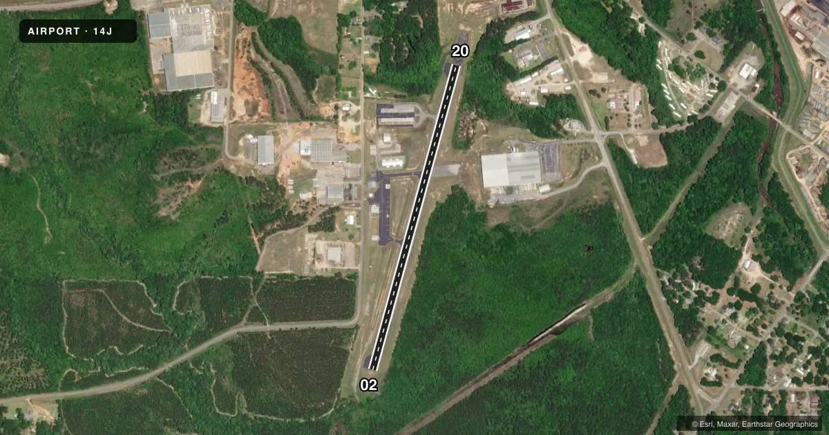
Full pagePattern entry · RWY 02
LEFT TRAFFICAirport sketch
Runways drawn to scale from FAA survey coordinates, rendered over satellite imagery. Not for navigation.
Approaches & charts
Services on the field
Fuel grades, oxygen, maintenance, ramp storage and lighting — as declared to the FAA by the airport operator.
Fuel & services
- Fuel
- 100LL
- Oxygen (bottled)
- Not available
- Oxygen (bulk)
- Not available
- Airframe repair
- Major
- Power plant repair
- Major
Ramp & ground
- Transient storage
- Tie-down
- Landing fee
- No fee published
- Customs
- Not available
- Lighting schedule
- SEE RMK
- Beacon schedule
- SS-SR
- Beacon
- White / Green (civil land)(WG)
- Wind indicator
- Lighted
- Segmented circle
- No
Fuel & FBOs
Cheapest 100LL and Jet A on the field and nearby. Always confirm with the FBO before taxi.
Airport notes
Surface conditions, obstructions, local procedures, lighting outages and other notes published with each FAA cycle.
General notes
- FOR CD CTC CAIRNS APCH AT 334-255-8402 OR 334-255-8460, WHEN APCH CLSD CTC JACKSONVILLE ARTCC AT 904-845-1592.
Lighting notes
- AFTER DUSK ACTVT MIRL RWY 02/20 - CTAF.
Fuel notes
- 100LLFUEL 24 HR CREDIT CARD SVC AVBL.
Runway surface & condition
- 02/20CLSD TO HEL MOV SKID LDG.
- 02/20RWY 02/20 HAS 344 FT BY 100 FT ASPHALT OVERRUN ON THE NORTH END.
Approach & departure obstructions
- 02CL STRIPES FADED
- 20CL STRIPES FADED
Other notes
- MANAGER334-389-3519 ALTN NR - MGR.
VFR map & nearby airports
VFR sectional. Tap any ICAO chip to open that airport.
Key facts · 14J
Answer card- ICAO
- 14J
- Name
- CARL FOLSOM
- Location
- ELBA, ALABAMA
- Elevation
- 258 ft MSL
- Traffic pattern altitude
- 1,258 ft MSL (1,000 AGL)
- Control tower
- Non-towered (use CTAF)
- Total runways
- 1
- Longest runway
- 02/20 · 3,050 ft
- Published ILS approaches
- 0
- Published frequencies
- 1
- Magnetic variation
- 0°
- Current flight rules
- VFR
- Current wind
- 000° at 0 kt
- Favored runway now
- –
Carl Folsom Airport sits in Elba, Alabama. Field elevation is 258 ft MSL. The airport has one runway. Runway 02/20 is 3,050 ft long and asphalt. There is no control tower. CTAF is 122.9. No ILS approaches are published here.
Pattern altitude is not published in the facts. Use the standard 1,000 ft AGL pattern unless the current Chart Supplement says otherwise. The on-field FBO is Carl Folsom Airport. It carries 100LL. Fuel is available 24 hours with credit card service. The published remarks also note a 344 ft by 100 ft asphalt overrun on the north end of runway 02/20. Centerline stripes are faded on both runway directions. Runway 02/20 is closed to helicopter movement skid landings.
After dusk, medium intensity runway lights on 02/20 are activated from CTAF. For clearance delivery, contact Cairns Approach. If approach is closed, contact Jacksonville ARTCC. This is a small non-towered field, so plan your self-announce calls early and keep an eye out for local traffic. Check the current FAA Chart Supplement for any current noise or operational notes before you go.