METAR & TAF 1A4
1A4 does not publish a METAR.
Showing the nearest reporting station: KEDN (ENTERPRISE MUNI) · 14.4 NM away. Conditions at 1A4 may differ.
METAR · KEDN
Observed 06:15Z
KEDN 270615Z AUTO 00000KT 10SM BKN050 BKN060 25/24 A2995 RMK AO1 T02520238
- Wind
- 000° @ 0 kt
- Visibility
- 10 SM
- Temp / Dew
- 25°C / 24°C
- Altimeter
- 29.95 inHg
- Clouds
- BKN
- Density alt
- 1,411 ft
- Ceiling
- 5,000 ft AGL
- Rules
- VFR
Airport info & contacts
Manager on record, flight service, ARTCC, attendance schedule and pattern altitude — published by the FAA and refreshed every 28 days.
Location
- From city
- 1 NM SW
- VFR sectional
- NEW ORLEANS
- ARTCC
- ZJX · JACKSONVILLE
- NOTAM facility
- ANB (NOTAM-D)
Airport manager
- Name
- AIR HAMMER/MIKE PASCOE
- Phone
- 334-898-1303
- Address
- 395 S. MAGNOLIA ST, SAMSON AL 36477
Flight service · Hours
- FSS ANB
- ANNISTON1-800-WX-BRIEF
- Attendance
- Unattended
Frequencies
Tap any row to copy the frequency to your clipboard.
Runways & pattern
Full pagePattern entry · RWY 05
LEFT TRAFFICRunway end performance
| End | TORA | TODA | ASDA | LDA | VGSI | Approach lights | Obstruction |
|---|---|---|---|---|---|---|---|
| 05 | — | — | — | — | — | — | 45', tree, 1041' from thr, 133' R of cntrln, slope 18 |
| 23 | — | — | — | — | — | — | 98', tree, 1428' from thr, 51' R of cntrln, slope 12 |
Declared distances in feet. TORA = takeoff run available, TODA = takeoff distance, ASDA = accelerate-stop, LDA = landing distance.
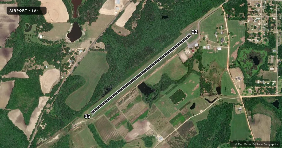
Airport sketch
Runways drawn to scale from FAA survey coordinates, rendered over satellite imagery. Not for navigation.
Approaches & charts
Services on the field
Fuel grades, oxygen, maintenance, ramp storage and lighting — as declared to the FAA by the airport operator.
Fuel & services
- Fuel
- Not available
- Oxygen (bottled)
- Not available
- Oxygen (bulk)
- Not available
- Airframe repair
- Not available
- Power plant repair
- Not available
Ramp & ground
- Transient storage
- Tie-down
- Lighting schedule
- SEE RMK
- Beacon schedule
- SS-SR
- Beacon
- White / Green (civil land)(WG)
- Wind indicator
- Yes
- Segmented circle
- No
Fuel & FBOs
Cheapest 100LL and Jet A on the field and nearby. Always confirm with the FBO before taxi.
Airport notes
Surface conditions, obstructions, local procedures, lighting outages and other notes published with each FAA cycle.
General notes
- RY 5/23 CLSD TO HEL WITH TAILWHEELS EXC ADJ SOD AREA.
- FOR CD CTC CAIRNS APCH AT 334-255-8402 OR 334-255-8460, WHEN APCH CLSD CTC JACKSONVILLE ARTCC AT 904-845-1592.
Lighting notes
- ACTVT MIRL RY 05/23 - CTAF.
Approach & departure obstructions
- 05MARKINGS FADED
- 23MARKINGS FADED
- 0511:1 SLOPE TO DSPLCD THR.
- 2311:1 SLOPE TO DSPLCD THR.
Other notes
- MANAGERAFTER HOURS 334-898-2700 OR 334-449-1580.
VFR map & nearby airports
VFR sectional. Tap any ICAO chip to open that airport.
Key facts · 1A4
Answer card- ICAO
- 1A4
- Name
- LOGAN FLD
- Location
- SAMSON, ALABAMA
- Elevation
- 200 ft MSL
- Traffic pattern altitude
- 1,200 ft MSL (1,000 AGL)
- Control tower
- Non-towered (use CTAF)
- Total runways
- 1
- Longest runway
- 05/23 · 3,596 ft
- Published ILS approaches
- 0
- Published frequencies
- 1
- Magnetic variation
- –
- Current flight rules
- VFR
- Current wind
- 000° at 0 kt
- Favored runway now
- –
Logan Fld sits in Samson, Alabama at 200 ft MSL. It has one runway, 05/23, which is 3,596 ft long. There is no control tower, so CTAF 122.9 is the published frequency for traffic and runway light activation. No ILS approaches are published here.
Pattern altitude is not published. Use the standard 1,000 ft AGL unless the current Chart Supplement says otherwise. That puts the light aircraft pattern at about 1,200 ft MSL based on the field elevation, but verify the published pattern before you fly it. Runway 05 and runway 23 both have faded markings. The runway lights are medium intensity and are activated by CTAF. The published remarks also note an 11 to 1 slope to the displaced threshold on both ends, so plan your landing distance carefully.
No on-field FBOs are listed. Contact the airport operator directly before arrival if you need fuel or ramp details. For clearance delivery, call Cairns Approach at the numbers in the Chart Supplement. If approach is closed, Jacksonville ARTCC handles the call. Pilots should also note that runway 5/23 is closed to helicopters with tailwheels except in the adjusted sod area.