METAR & TAF KEDN
Current METAR
Observed 11:15Z
KEDN 271115Z AUTO 00000KT 7SM CLR 24/24 A2993 RMK AO1 T02420238
- Wind
- 000° @ 0 kt
- Visibility
- 7 SM
- Temp / Dew
- 24°C / 24°C
- Altimeter
- 29.93 inHg
- Clouds
- CLR
- Density alt
- 1,515 ft
- Ceiling
- Unlimited
- Rules
- VFR
Airport info & contacts
Manager on record, flight service, ARTCC, attendance schedule and pattern altitude — published by the FAA and refreshed every 28 days.
Location
- From city
- 3 NM W
- VFR sectional
- NEW ORLEANS
- Pattern altitude
- 800 ft AGL · 1,161 ft MSL
- ARTCC
- ZJX · JACKSONVILLE
- NOTAM facility
- ANB (NOTAM-D)
Airport manager
- Name
- BARRY MOTT
- Phone
- 334-348-2676
- Address
- 863 AVIATION BLVD., ENTERPRISE AL 36330
Flight service · Hours
- FSS ANB
- ANNISTON1-800-WX-BRIEF
- Attendance
- MONDAY - FRIDAY · 0700 - 1700
- SATURDAY · 0800 - 1700
- SUNDAY · Unattended
Frequencies
Tap any row to copy the frequency to your clipboard.
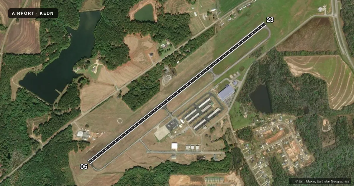
Runways & pattern
Full pagePattern entry · RWY 05
LEFT TRAFFICRunway end performance
| End | TORA | TODA | ASDA | LDA | VGSI | Approach lights | Obstruction |
|---|---|---|---|---|---|---|---|
| 05 | — | — | — | — | PAPI 2-box left(3°) | — | 27', tree, 726' from thr, 130' R of cntrln, slope 19 |
| 23 | — | — | — | — | PAPI 2-box left(3.5°) | — | — |
Declared distances in feet. TORA = takeoff run available, TODA = takeoff distance, ASDA = accelerate-stop, LDA = landing distance.
Airport sketch
Runways drawn to scale from FAA survey coordinates, rendered over satellite imagery. Not for navigation.
Approaches & charts
Services on the field
Fuel grades, oxygen, maintenance, ramp storage and lighting — as declared to the FAA by the airport operator.
Fuel & services
- Fuel
- 100LLA+
- Oxygen (bottled)
- Not available
- Oxygen (bulk)
- Not available
- Airframe repair
- Minor
- Power plant repair
- Minor
- Other services
- INSTR,RNTL
Ramp & ground
- Transient storage
- Tie-down
- Landing fee
- No fee published
- Customs
- Not available
- Lighting schedule
- SEE RMK
- Beacon schedule
- SS-SR
- Beacon
- White / Green (civil land)(WG)
- Wind indicator
- Lighted
- Segmented circle
- Yes
Fuel & FBOs
Cheapest 100LL and Jet A on the field and nearby. Always confirm with the FBO before taxi.
Airport notes
Surface conditions, obstructions, local procedures, lighting outages and other notes published with each FAA cycle.
General notes
- FOR CD CTC CAIRNS APCH AT 334-255-8402, WHEN APCH CLSD CTC JACKSONVILLE ARTCC AT 904-845-1592.
Lighting notes
- REIL RWY 05 & 23; PAPI RWY 05 & 23; MIRL RWY 5/23 OPER DUSK-2330; AFTER 2330 ACTVT - CTAF.
Other notes
- EXISTED PRIOR TO MAY 15, 1959.
- 800 FT AGL FOR CAT A AND B ACFT, 1500 FT AGL FOR CAT C ACFT.
- MANAGERADDL PHONE 334-348-2673; AFT HRS 334-406-7676.
VFR map & nearby airports
VFR sectional. Tap any ICAO chip to open that airport.
Key facts · KEDN
Answer card- ICAO
- KEDN
- Name
- ENTERPRISE MUNI
- Location
- ENTERPRISE, ALABAMA
- Elevation
- 360.9 ft MSL
- Traffic pattern altitude
- 1,160.9 ft MSL (800 AGL)
- Control tower
- Non-towered (use CTAF)
- Total runways
- 1
- Longest runway
- 05/23 · 5,080 ft
- Published ILS approaches
- 0
- Published frequencies
- 4
- Magnetic variation
- 3°
- Current flight rules
- VFR
- Current wind
- 000° at 0 kt
- Favored runway now
- –
Enterprise Muni is in Enterprise, Alabama. The field elevation is 360.9 ft MSL. It has one runway, 05/23, which is 5,080 ft of asphalt. There is no control tower. The airport uses CTAF 122.8 and UNICOM 122.8. No ILS approaches are published here.
The published pattern altitude is 800 ft AGL for Category A and B aircraft. That is 1,160.9 ft MSL. Category C aircraft use 1,500 ft AGL. That is 1,860.9 ft MSL. Runway end identifier lights are installed on both ends. PAPI is also installed on 05 and 23. Medium intensity runway lights operate from dusk to 2330. After 2330, lighting activation is by CTAF.
Enterprise Municipal Airport is the on-field FBO. It carries 100LL and Jet A Prist. For clearance delivery, Cairns Approach is the published contact. When approach is closed, Jacksonville ARTCC is the fallback contact. First-time pilots should plan for an uncontrolled field with published lighting procedures. Check the current FAA Chart Supplement for any changes before you go.