METAR & TAF KDHN
Current METAR
Observed 11:53Z
KDHN 271153Z 28005KT 10SM CLR 26/23 A2997 RMK AO1 SLP141 T02610233 10261 20250 53008 $
- Wind
- 280° @ 5 kt
- Visibility
- 10 SM
- Temp / Dew
- 26°C / 23°C
- Altimeter
- 29.97 inHg
- Clouds
- CLR
- Density alt
- 1,755 ft
- Ceiling
- Unlimited
- Rules
- VFR
Airport info & contacts
Manager on record, flight service, ARTCC, attendance schedule and pattern altitude — published by the FAA and refreshed every 28 days.
Location
- From city
- 5 NM NW
- VFR sectional
- NEW ORLEANS
- ARTCC
- ZJX · JACKSONVILLE
- NOTAM facility
- DHN (NOTAM-D)
Airport manager
- Name
- ADAM HARTZOG
- Phone
- 334-983-8108
- Address
- 800 ARPT DR SUITE 15, DOTHAN AL 36303
Flight service · Hours
- FSS ANB
- ANNISTON1-800-WX-BRIEF
- Attendance
- ALL
Frequencies
Tap any row to copy the frequency to your clipboard.
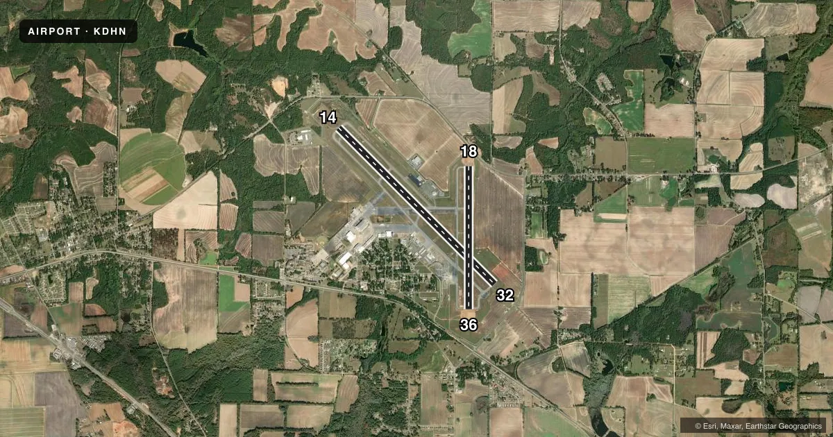
Runways & pattern
Full pagePattern entry · RWY 32
LEFT TRAFFIC| Runway | Heading (°M) | Length | Surface | Traffic |
|---|---|---|---|---|
| 14/32Favored | 132° / 312° | 8,500 ft | ASPH | Standard L |
| 18/36 | 177° / 357° | 5,501 ft | ASPH | Standard L |
Runway end performance
| End | TORA | TODA | ASDA | LDA | VGSI | Approach lights | Obstruction |
|---|---|---|---|---|---|---|---|
| 14 | 8,500' | 8,500' | 8,500' | 8,500' | PAPI 2-box left(3°) | — | — |
| 32 | 8,500' | 8,500' | 8,500' | 8,500' | — | MALSR | — |
| 18 | 5,501' | 5,501' | 5,501' | 5,401' | PAPI 4-box left(3°) | — | 48', trees, 1400' from thr, 100' R of cntrln, slope 25 |
| 36 | 5,401' | 5,401' | 5,501' | 5,501' | — | — | 80', trees, 2050' from thr, 450' R of cntrln, slope 23 |
Declared distances in feet. TORA = takeoff run available, TODA = takeoff distance, ASDA = accelerate-stop, LDA = landing distance.
Airport sketch
Runways drawn to scale from FAA survey coordinates, rendered over satellite imagery. Not for navigation.
Approaches & charts
ILS · 2
Services on the field
Fuel grades, oxygen, maintenance, ramp storage and lighting — as declared to the FAA by the airport operator.
Fuel & services
- Fuel
- 100LLA
- Oxygen (bottled)
- Not available
- Oxygen (bulk)
- Not available
- Airframe repair
- Major
- Power plant repair
- Major
- Other services
- AFRT,AVNCS,CARGO,CHTR,INSTR,RNTL,SALES,TOW
Ramp & ground
- Transient storage
- Tie-down
- Hangar
- Landing fee
- No fee published
- Customs
- Not available
- Lighting schedule
- SEE RMK
- Beacon schedule
- SS-SR
- Beacon
- White / Green (civil land)(WG)
- Wind indicator
- Lighted
- Segmented circle
- Yes
Fuel & FBOs
Cheapest 100LL and Jet A on the field and nearby. Always confirm with the FBO before taxi.
Airport notes
Surface conditions, obstructions, local procedures, lighting outages and other notes published with each FAA cycle.
General notes
- MAXI WID TWY A IS 75 FT FOR RWY 14/32.
- RSTD: USAF NA TO OPER C130 ACFT ON RWY 18/36.
- ARFF PSNL ON DUTY AT ARPT 24 HRS.
- FUEL A, A+ (C334 983 4541) (NC 100LL).
- LN OF SIGHT FROM DOTHAN ATC TO A PTN OF TXY BRAVO BTN TXY ALPHA AND THE APCH END OF RWY 36 OBSTD BY THE AP BLDG.
- FOR CD WHEN TWR CLSD IF UNA RDO, CTC CAIRNS APCH C334-255-8402. WHEN APCH CLSD CTC JACKSONVILLE ARTCC C904-845-1592.
- APRON NORTH CLSD EXC MIL. 24 HR PPR OTRW 334-873-2408.
Lighting notes
- WHEN ATCT CLSD, ACTVT MALSR RWY 32; REIL RWY 14 & 18; PAPI RWY 14; HIRL RWY 14/32 - CTAF. PAPI RWY 18; MIRL RWY 18/36 AVBL BY PRIOR REQ DURG ATNDD HRS, CALL 334-983-8100/8103.
Runway surface & condition
- 14/32PCR VALUE: 420/F/A/X/T
- 18/36PCR VALUE: 325/F/A/X/T
Other notes
- ARPT CONST BEFORE FAA ACT NO AIRSPACE ACTION ON FILE IN AREA OFFICE.
- ARFF INDEX B AVAILABLE; 48 HR PPR FOR UNSKED ACR OPNS WITH MORE THAN 30 PSGR SEATS 2300-0600 CALL AMGR 334-983-8100.
- MISC: LDG FEE FOR PART 135 OPS.
VFR map & nearby airports
VFR sectional. Tap any ICAO chip to open that airport.
Key facts · KDHN
Answer card- ICAO
- KDHN
- Name
- DOTHAN RGNL
- Location
- DOTHAN, ALABAMA
- Elevation
- 400.8 ft MSL
- Traffic pattern altitude
- 1,400.8 ft MSL (1,000 AGL)
- Control tower
- Towered · 0600-2100 MON-FRI; 0800-2000 SAT & SUN.
- Total runways
- 2
- Longest runway
- 14/32 · 8,500 ft
- Published ILS approaches
- 2
- Published frequencies
- 9
- Magnetic variation
- 3°
- Current flight rules
- VFR
- Current wind
- 280° at 5 kt
- Favored runway now
- RWY 32
Dothan Rgnl is in Dothan, Alabama. Field elevation is 400.8 ft MSL. The airport has two asphalt runways. The longest is runway 14/32 at 8,500 ft. Runway 18/36 is 5,501 ft.
The tower is open 0600-2100 Monday through Friday. Weekend hours are 0800-2000 Saturday and Sunday. Two ILS approaches are published. They serve runway ends 14 and 32. Pattern altitude is not published in the facts, so verify the current Chart Supplement before you go. For a light piston, plan on the standard 1,000 ft AGL unless current published data says otherwise.
Aero-One Aviation is on the field. It carries Jet A and Jet A Plus. No 100LL is available. The airport also has ARFF index B on site. That matters if you are planning a larger operation or a late arrival. Published remarks note an obstructed line of sight from the tower to part of taxiway Bravo near taxiway Alpha and the approach end of runway 36. Taxi with that in mind. The north apron is closed except for military use. Twenty-four hour prior permission is required otherwise.
This is a controlled field with active airline-style procedures. Check the current Chart Supplement for any noise or curfew restrictions before flying in. If you are coming in after tower hours, review the lighting and clearance notes before departure.