METAR & TAF KMAI
Current METAR
Observed 11:53Z
KMAI 271153Z AUTO 29005KT 10SM CLR 26/24 A2992 RMK AO2 SLP128 T02610244 10267 20256 51008
- Wind
- 290° @ 5 kt
- Visibility
- 10 SM
- Temp / Dew
- 26°C / 24°C
- Altimeter
- 29.92 inHg
- Clouds
- CLR
- Density alt
- 1,457 ft
- Ceiling
- Unlimited
- Rules
- VFR
Airport info & contacts
Manager on record, flight service, ARTCC, attendance schedule and pattern altitude — published by the FAA and refreshed every 28 days.
Location
- From city
- 4 NM NE
- VFR sectional
- NEW ORLEANS
- ARTCC
- ZJX · JACKSONVILLE
- NOTAM facility
- MAI (NOTAM-D)
Airport manager
- Name
- CLAY WELLS
- Phone
- 850-482-2281
- Address
- MARIANNA MUNICIPAL AIRPORT, 3689 INDUSTRIAL PARK DR, MARIANNA FL 32446
Flight service · Hours
- FSS GNV
- GAINESVILLE1-800-WX-BRIEF
- Attendance
- MON-FRI · 0800-1700
Frequencies
Tap any row to copy the frequency to your clipboard.
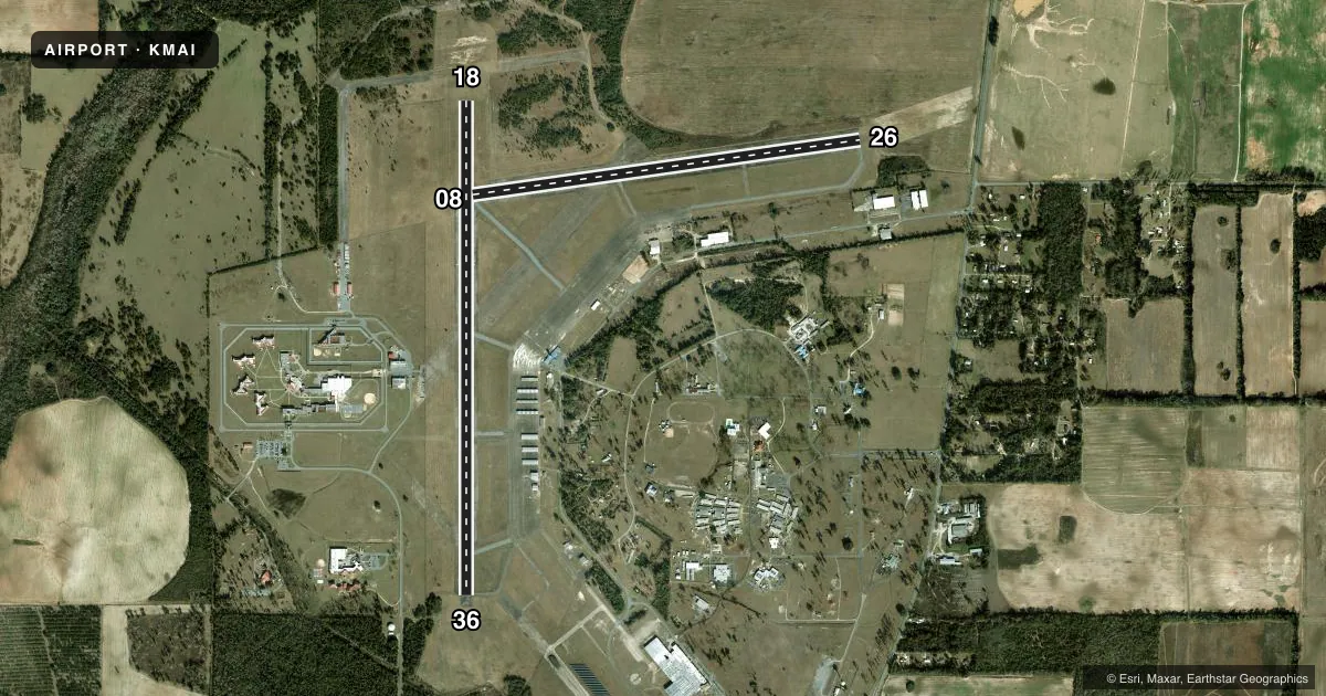
Runways & pattern
Full pagePattern entry · RWY 26
LEFT TRAFFIC| Runway | Heading (°M) | Length | Surface | Traffic |
|---|---|---|---|---|
| 18/36 | 178° / 358° | 6,001 ft | ASPH | Standard L |
| 08/26Favored | 80° / 260° | 4,763 ft | ASPH | Standard L |
Runway end performance
| End | TORA | TODA | ASDA | LDA | VGSI | Approach lights | Obstruction |
|---|---|---|---|---|---|---|---|
| 18 | — | — | — | — | PAPI 4-box left(2.83°) | — | 34', trees, 1070' from thr, 35' R of cntrln, slope 25 |
| 36 | — | — | — | — | PAPI 4-box left(3°) | — | 61', trees, 1950' from thr, 185' R of cntrln, slope 28 |
| 08 | — | — | — | — | — | — | 47', trees, 1820' from thr, 35' R of cntrln, slope 34 |
| 26 | — | — | — | — | — | — | 39', pline, 1440' from thr, 0' R of cntrln, slope 31 |
Declared distances in feet. TORA = takeoff run available, TODA = takeoff distance, ASDA = accelerate-stop, LDA = landing distance.
Airport sketch
Runways drawn to scale from FAA survey coordinates, rendered over satellite imagery. Not for navigation.
Approaches & charts
Services on the field
Fuel grades, oxygen, maintenance, ramp storage and lighting — as declared to the FAA by the airport operator.
Fuel & services
- Fuel
- 100LLA
- Oxygen (bottled)
- Not available
- Oxygen (bulk)
- Not available
- Airframe repair
- Major
- Power plant repair
- Major
- Other services
- AMB,GLD,INSTR,TOW
Ramp & ground
- Transient storage
- Tie-down
- Hangar
- Landing fee
- No fee published
- Customs
- Not available
- Lighting schedule
- SEE RMK
- Beacon schedule
- SS-SR
- Beacon
- White / Green (civil land)(WG)
- Wind indicator
- Lighted
- Segmented circle
- Yes
Fuel & FBOs
Cheapest 100LL and Jet A on the field and nearby. Always confirm with the FBO before taxi.
Airport notes
Surface conditions, obstructions, local procedures, lighting outages and other notes published with each FAA cycle.
General notes
- MIL HEL OPS ON & INVOF ARPT.
- FOR CD CTC CAIRNS APCH AT 334-255-8402, WHEN APCH CLSD CTC JACKSONVILLE ARTCC AT 904-845-1592.
Lighting notes
- ACTVT PAPI RWY 18 & 36; MIRL RWY 18/36 - CTAF.
Approach & departure obstructions
- 08FADED.
- 26FADED.
Other notes
- 1EXCLUDING HOLIDAYS.
- 1FOR SVC AFTER HRS CALL 850-482-2281.
- MANAGERALT CTC: KATIE O'CONNOR - KOCONNOR@MARIANNAFL.CITY
- OWNERCONTACT PERSON: WILLIAM LONG, CITY MANAGER 850-482-4353.
- 08/26RWY 08/26 CRACKING WITH GRASS GROWING & PRODUCING LOOSE AGGREGATE.
VFR map & nearby airports
VFR sectional. Tap any ICAO chip to open that airport.
Key facts · KMAI
Answer card- ICAO
- KMAI
- Name
- MARIANNA MUNI
- Location
- MARIANNA, FLORIDA
- Elevation
- 110.7 ft MSL
- Traffic pattern altitude
- 1,110.7 ft MSL (1,000 AGL)
- Control tower
- Non-towered (use CTAF)
- Total runways
- 2
- Longest runway
- 18/36 · 6,001 ft
- Published ILS approaches
- 0
- Published frequencies
- 4
- Magnetic variation
- 2°
- Current flight rules
- VFR
- Current wind
- 290° at 5 kt
- Favored runway now
- RWY 26
Marianna Muni sits in Marianna, Florida. Field elevation is 110.7 ft MSL. The airport has two asphalt runways. The longest is 18/36 at 6,001 ft. Runway 08/26 is 4,763 ft.
This is a non-towered field. CTAF and UNICOM are both 123.0. Approach and departure service is handled by Cairns on 133.75 and 270.35. No ILS approaches are published here. Pattern altitude is not published. Use 1,000 ft AGL for light piston operations unless the current Chart Supplement says otherwise.
The on-field FBO is Marianna Municipal Airport. It carries 100LL and Jet A with Prist. Call (850) 482-2281 for current service. Airport attendance is available except on holidays. After hours service is also listed at the same number.
A few operational notes matter here. Military helicopter operations occur on and near the airport. Runway 18 and 36 lighting, plus the PAPI on those runways, are activated by CTAF. Runway 08/26 has cracking with grass and loose aggregate. Runway 08 and 26 markings are faded. For a first visit, plan for a careful runway check and stay alert for helicopter traffic. If you need clearance delivery, contact Cairns Approach. If approach is closed, contact Jacksonville ARTCC.