METAR & TAF KBGE
Current METAR
Observed 13:15Z
KBGE 271315Z AUTO 28005KT 10SM CLR 28/27 A2994 RMK AO2 T02830271
- Wind
- 280° @ 5 kt
- Visibility
- 10 SM
- Temp / Dew
- 28°C / 27°C
- Altimeter
- 29.94 inHg
- Clouds
- CLR
- Density alt
- 1,710 ft
- Ceiling
- Unlimited
- Rules
- VFR
Airport info & contacts
Manager on record, flight service, ARTCC, attendance schedule and pattern altitude — published by the FAA and refreshed every 28 days.
Location
- From city
- 6 NM NW
- VFR sectional
- JACKSONVILLE
- ARTCC
- ZJX · JACKSONVILLE
- NOTAM facility
- MCN (NOTAM-D)
Airport manager
- Name
- TOMMY JOHNSON
- Phone
- 229-416-7776
- Address
- 413 4TH RAMP, BAINBRIDGE GA 39817
Flight service · Hours
- FSS MCN
- MACON1-800-WX-BRIEF
- Attendance
- 0800-1800
Frequencies
Tap any row to copy the frequency to your clipboard.
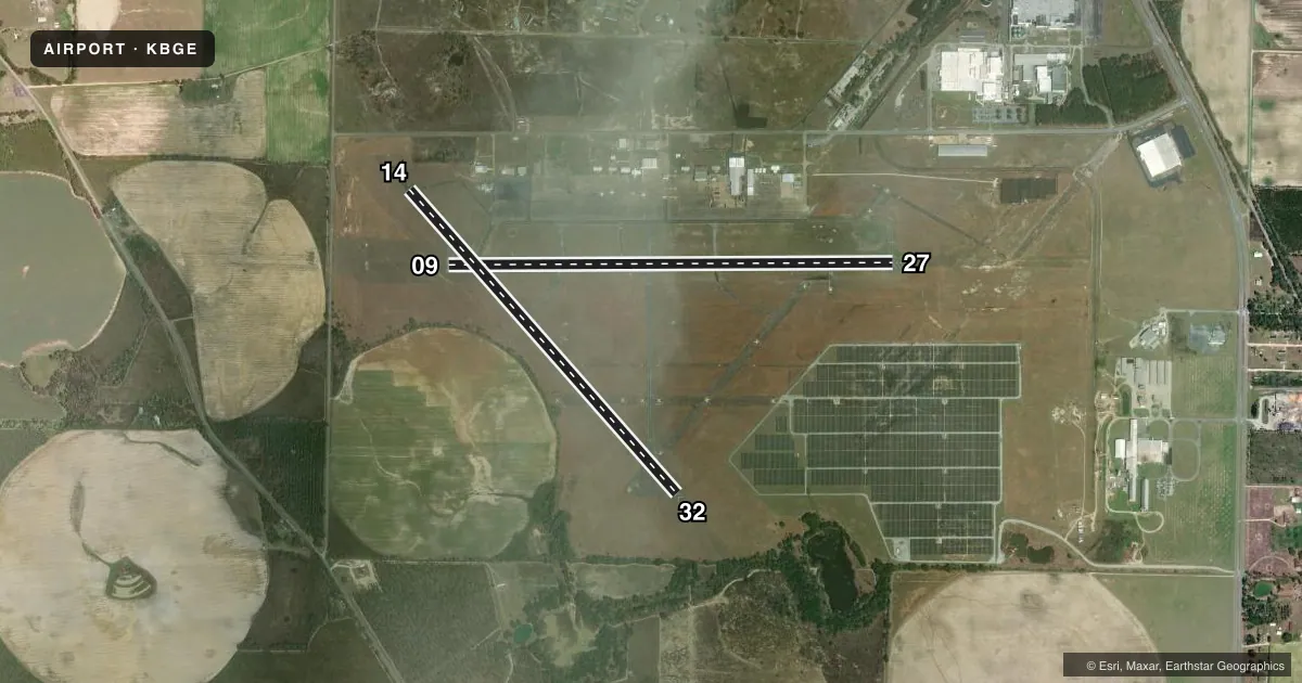
Runways & pattern
Full pagePattern entry · RWY 27
LEFT TRAFFIC| Runway | Heading (°M) | Length | Surface | Traffic |
|---|---|---|---|---|
| 09/27Favored | 86° / 266° | 5,502 ft | ASPH | Standard L |
| 14/32 | 135° / 315° | 5,003 ft | ASPH | Standard L |
Runway end performance
| End | TORA | TODA | ASDA | LDA | VGSI | Approach lights | Obstruction |
|---|---|---|---|---|---|---|---|
| 09 | — | — | — | — | PAPI 2-box left(3°) | — | — |
| 27 | — | — | — | — | PAPI 2-box left(3°) | MALSR | 93', trees, 4478' from thr, 606' R of cntrln, slope 46 |
Declared distances in feet. TORA = takeoff run available, TODA = takeoff distance, ASDA = accelerate-stop, LDA = landing distance.
Airport sketch
Runways drawn to scale from FAA survey coordinates, rendered over satellite imagery. Not for navigation.
Approaches & charts
ILS · 1
Services on the field
Fuel grades, oxygen, maintenance, ramp storage and lighting — as declared to the FAA by the airport operator.
Fuel & services
- Fuel
- 100LLA+
- Oxygen (bottled)
- Not available
- Oxygen (bulk)
- Not available
- Airframe repair
- Minor
- Power plant repair
- Minor
- Other services
- AGRI,INSTR,RNTL
Ramp & ground
- Transient storage
- Tie-down
- Hangar
- Landing fee
- No fee published
- Customs
- Not available
- Lighting schedule
- SEE RMK
- Beacon schedule
- SS-SR
- Beacon
- White / Green (civil land)(WG)
- Wind indicator
- Lighted
- Segmented circle
- Yes
Fuel & FBOs
Cheapest 100LL and Jet A on the field and nearby. Always confirm with the FBO before taxi.
Airport notes
Surface conditions, obstructions, local procedures, lighting outages and other notes published with each FAA cycle.
General notes
- EXTENSIVE STUDENT PILOT TRNG ON AND INVOF ARPT.
- FOR CD IF UNA ON FREQ CTC TALLAHASSEE APCH AT 850-942-8311. WHEN APCH CLSD, CTC JACKSONVILLE ARTCC AT 904-845-1592.
Lighting notes
- PAPI RWY 09 & 27 OPR CONSLY DUSK-2200. HIRL RWY 09/27 PRESET MED INTST DUSK-2200; TO INCR INTST - CTAF. AFTER 2200, ACTVT PAPI RWY 09 &27; HIRL RWY 09/27 - CTAF. MALSR RWY 27 - CTAF.
Fuel notes
- 100LLSELF SVC FUEL 24 HRS WITH CREDIT CARD.
Approach & departure obstructions
- 27RWY 27 PAPI UNUSBL BYD 8 DEG RIGHT OF RCL.
Other notes
- EXISTED PRIOR TO 1959.
- ALL ACFT OPERATING LOCALLY AT BGE MUST HAVE A TWO-WAY RADIO CAPABLE OF TRANSMITTING/RECEIVING ON CTAF FREQ; ONE-STOP TRANSIENT ACFT ARE EXEMPT FROM THIS REQUIREMENT.
VFR map & nearby airports
VFR sectional. Tap any ICAO chip to open that airport.
Key facts · KBGE
Answer card- ICAO
- KBGE
- Name
- DECATUR COUNTY INDUSTRIAL AIR PARK
- Location
- BAINBRIDGE, GEORGIA
- Elevation
- 141.3 ft MSL
- Traffic pattern altitude
- 1,141.3 ft MSL (1,000 AGL)
- Control tower
- Non-towered (use CTAF)
- Total runways
- 2
- Longest runway
- 09/27 · 5,502 ft
- Published ILS approaches
- 1
- Published frequencies
- 6
- Magnetic variation
- 4°
- Current flight rules
- VFR
- Current wind
- 280° at 5 kt
- Favored runway now
- RWY 27
Decatur County Industrial Air Park is in Bainbridge, Georgia. The field elevation is 141.3 ft MSL. It has 2 asphalt runways. The longest is 5,502 ft on runway 09/27. There is no control tower, so plan for CTAF work and local traffic flow.
The airport has 1 ILS approach. It serves runway 27. Pattern altitude is not published in the facts, so verify the current Chart Supplement before you go. The on-field FBO is Decatur County Airport. It carries AVGAS 100LL and Jet A Prist. Self-service 100LL is available 24 hours with a credit card.
A few operational notes matter here. Local training traffic is heavy. All aircraft operating locally must have a two-way radio that can transmit and receive on CTAF. Runway 09 and 27 lighting is available by CTAF after 2200. The PAPI for 09 and 27 runs continuously from dusk to 2200. Runway 27 also has MALSR available via CTAF. If you need clearance delivery and the frequency is not available, contact Tallahassee Approach. If approach is closed, contact Jacksonville ARTCC. For a first-time arrival, brief the lighting setup. Expect student traffic. Verify the current pattern altitude and any local procedures before departure.