METAR & TAF F95
Current METAR
Observed 05:35Z
KF95 270535Z AUTO 00000KT 9SM SCT060 26/26 A2996 RMK AO2
- Wind
- 000° @ 0 kt
- Visibility
- 9 SM
- Temp / Dew
- 26°C / 26°C
- Altimeter
- 29.96 inHg
- Clouds
- SCT
- Density alt
- 1,421 ft
- Ceiling
- Unlimited
- Rules
- VFR
Airport info & contacts
Manager on record, flight service, ARTCC, attendance schedule and pattern altitude — published by the FAA and refreshed every 28 days.
Location
- From city
- 5 NM NW
- VFR sectional
- NEW ORLEANS
- ARTCC
- ZJX · JACKSONVILLE
- NOTAM facility
- GNV (NOTAM-D)
Airport manager
- Name
- ROB SIMS
- Phone
- 850-674-2499
- Address
- 16701 AGRIPARK ROAD, ALTHA FL 32421
Flight service · Hours
- FSS GNV
- GAINESVILLE1-800-WX-BRIEF
- Attendance
- MON-FRI · 0700-1700
Frequencies
Tap any row to copy the frequency to your clipboard.
Runways & pattern
Full pagePattern entry · RWY 18
LEFT TRAFFICRunway end performance
| End | TORA | TODA | ASDA | LDA | VGSI | Approach lights | Obstruction |
|---|---|---|---|---|---|---|---|
| 18 | — | — | — | — | PAPI 2-box left(3°) | — | 45', trees, 980' from thr, 135' R of cntrln, slope 28 |
| 36 | — | — | — | — | PAPI 2-box left(3°) | — | 15', road, 355' from thr, 125' R of cntrln, slope 10 |
Declared distances in feet. TORA = takeoff run available, TODA = takeoff distance, ASDA = accelerate-stop, LDA = landing distance.
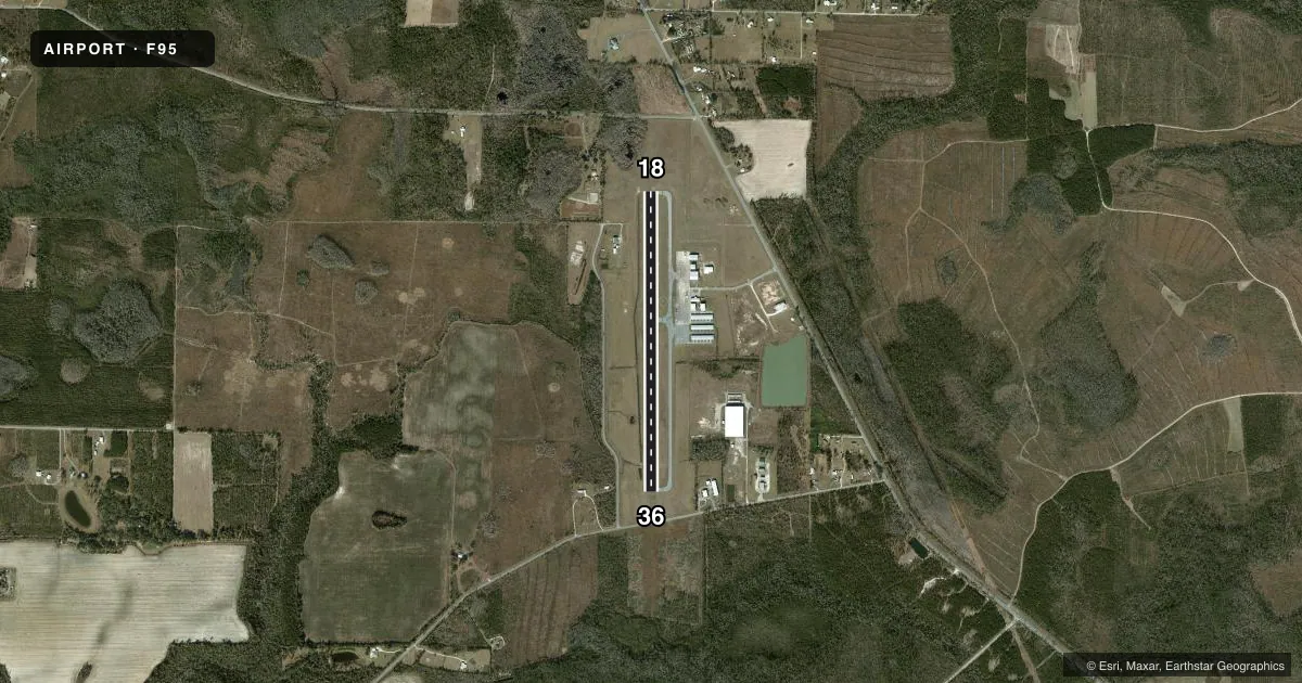
Airport sketch
Runways drawn to scale from FAA survey coordinates, rendered over satellite imagery. Not for navigation.
Approaches & charts
Services on the field
Fuel grades, oxygen, maintenance, ramp storage and lighting — as declared to the FAA by the airport operator.
Fuel & services
- Fuel
- 100LLA
- Oxygen (bottled)
- Not available
- Oxygen (bulk)
- Not available
- Airframe repair
- Major
- Power plant repair
- Major
- Other services
- AGRI,AMB,INSTR,PAJA
Ramp & ground
- Transient storage
- Tie-down
- Hangar
- Lighting schedule
- SEE RMK
- Beacon schedule
- SS-SR
- Beacon
- White / Green (civil land)(WG)
- Wind indicator
- Lighted
- Segmented circle
- Yes
Fuel & FBOs
Cheapest 100LL and Jet A on the field and nearby. Always confirm with the FBO before taxi.
Airport notes
Surface conditions, obstructions, local procedures, lighting outages and other notes published with each FAA cycle.
General notes
- FOR CD CTC TYNDALL APCH AT 850-283-2900 OR 850-283-3353, WHEN APCH CLSD CTC JACKSONVILLE ARTCC AT 904-845-1592.
Lighting notes
- ACTVT MIRL RWY 18/36; PAPI RWY 18 & 36 - CTAF.
Approach & departure obstructions
- 18RWY 18/36 MARKINGS DISCOLORED
- 36RWY 18/36 MARKINGS DISCOLORED
- 18APCH SLP 28:1 TO THE AER 18.
Other notes
- PRVDD OPNS VFR; ALL TFC OPNS ARE CONDUCTED N OF RY 13/31 AT BLOUNSTOWN ARPT TO PRVD COMPATIBLE TFC PATTERN WITH CALHOUN COUNTY ARPT; PLINE & TREES AT BOTH ENDS OF TY REMOVED.
- MANAGERAIRPORT PHYSICAL ADDRESS: 16701 NORTHWEST AGRIPARK ROAD, ALTHA, FL 3241 850-674-2499 FAX: 850-674-1578.
VFR map & nearby airports
VFR sectional. Tap any ICAO chip to open that airport.
Key facts · F95
Answer card- ICAO
- F95
- Name
- CALHOUN COUNTY
- Location
- BLOUNTSTOWN, FLORIDA
- Elevation
- 121.2 ft MSL
- Traffic pattern altitude
- 1,121.2 ft MSL (1,000 AGL)
- Control tower
- Non-towered (use CTAF)
- Total runways
- 1
- Longest runway
- 18/36 · 3,729 ft
- Published ILS approaches
- 0
- Published frequencies
- 1
- Magnetic variation
- 2°
- Current flight rules
- VFR
- Current wind
- 000° at 0 kt
- Favored runway now
- –
Calhoun County Airport (F95) sits in Blountstown, Florida. Field elevation is 121.2 ft MSL. The airport has one runway. Runway 18/36 is 3,729 ft of asphalt, so plan performance with that length in mind. There is no control tower. CTAF is 122.9.
No ILS approaches are published here. The published remarks say operations are VFR. They also note that all traffic operations are conducted north of runway 13/31 at Blountstown Airport to stay compatible with Calhoun County Airport. That is worth keeping in mind when you are briefing the pattern. The remarks also say runway 18/36 markings are discolored. Medium intensity runway lights are available on 18/36. PAPI is installed on runways 18 and 36 and is controlled by CTAF.
Pattern altitude is not published. Use 1,000 ft AGL for light piston traffic unless the current FAA Chart Supplement says otherwise. With the field sitting at 121.2 ft MSL, that puts a typical light aircraft pattern near 1,121 ft MSL. The on-field FBO is Calhoun County Airport. It carries 100LL and Jet A. If you need clearance delivery, the published remarks direct pilots to Tyndall Approach when open. If approach is closed, contact Jacksonville ARTCC.