METAR & TAF KBCR
Current METAR
Observed 12:58Z
KBCR 271258Z AUTO 00000KT 10SM CLR 28/25 A2995 RMK AO2 SLP099 T02780250 $
- Wind
- 000° @ 0 kt
- Visibility
- 10 SM
- Temp / Dew
- 28°C / 25°C
- Altimeter
- 29.95 inHg
- Clouds
- CLR
- Density alt
- 1,629 ft
- Ceiling
- Unlimited
- Rules
- VFR
Airport info & contacts
Manager on record, flight service, ARTCC, attendance schedule and pattern altitude — published by the FAA and refreshed every 28 days.
Location
- From city
- 6 NM NE
- VFR sectional
- NEW ORLEANS
- ARTCC
- ZJX · JACKSONVILLE
- NOTAM facility
- GNV (NOTAM-D)
Airport manager
- Name
- MARK WILSON
- Phone
- 850-703-6808
- Address
- 1983 TRI COUNTY AIRPORT RD, BONIFAY FL 32425
Flight service · Hours
- FSS GNV
- GAINESVILLE1-800-WX-BRIEF
- Attendance
- MON-FRI · 0830-1630
Frequencies
Tap any row to copy the frequency to your clipboard.
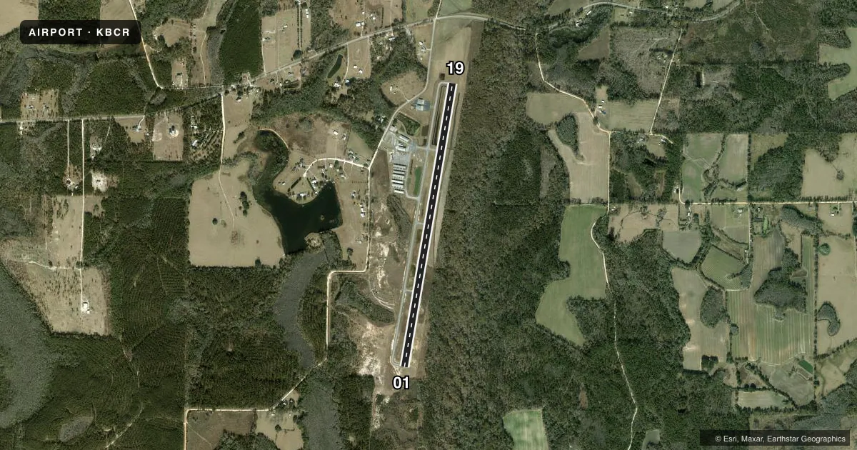
Runways & pattern
Full pagePattern entry · RWY 01
LEFT TRAFFICRunway end performance
| End | TORA | TODA | ASDA | LDA | VGSI | Approach lights | Obstruction |
|---|---|---|---|---|---|---|---|
| 01 | — | — | — | — | PAPI 2-box left(3°) | — | 10', brush, 220' from thr, 115' R of cntrln, slope 2 |
| 19 | — | — | — | — | PAPI 2-box left(3°) | — | 65', trees, 1490' from thr, 235' R of cntrln, slope 19 |
Declared distances in feet. TORA = takeoff run available, TODA = takeoff distance, ASDA = accelerate-stop, LDA = landing distance.
Airport sketch
Runways drawn to scale from FAA survey coordinates, rendered over satellite imagery. Not for navigation.
Approaches & charts
Services on the field
Fuel grades, oxygen, maintenance, ramp storage and lighting — as declared to the FAA by the airport operator.
Fuel & services
- Fuel
- 100LLA
- Oxygen (bottled)
- Not available
- Oxygen (bulk)
- Not available
- Airframe repair
- Not available
- Power plant repair
- Not available
- Other services
- AGRI,INSTR,PAJA
Ramp & ground
- Transient storage
- Tie-down
- Hangar
- Landing fee
- No fee published
- Customs
- Not available
- Lighting schedule
- SEE RMK
- Beacon schedule
- SS-SR
- Beacon
- White / Green (civil land)(WG)
- Wind indicator
- Lighted
- Segmented circle
- Yes
Fuel & FBOs
Cheapest 100LL and Jet A on the field and nearby. Always confirm with the FBO before taxi.
Airport notes
Surface conditions, obstructions, local procedures, lighting outages and other notes published with each FAA cycle.
General notes
- WILDLIFE ON RWY; MIL OPS DALGT HR.
- FOR CD CTC CAIRNS APCH AT 334-255-8402, WHEN APCH CLSD CTC JACKSONVILLE ARTCC AT 904-845-1592.
- EXTSV SKYDIVING OPS ON WKENDS.
- TREES & FENCE FULL LEN OF RWY 01/19 252 FT TO 300 FT E OF CNTRLN PENTS THE TRANSITIONAL SFC OF RWY 01/19.
Lighting notes
- ACTVT PAPI RWY 01 & 19; MIRL RWY 01/19 - CTAF.
Fuel notes
- 100LLSELF SVC FUEL AVBL.
Runway surface & condition
- 01/19RWY SAFETY AREA CONTAINS MULT WASHOUTS WI FIRST 1000 FT BOTH SIDES. FENCE 252 FT E OF CNTRLN PENETRATES TRSNL SFC.
Approach & departure obstructions
- 01TREES WIDTH OF RWY 252 FT FM RWY END 300 FT E OF CNTRLN PENETRATE TRSNL SFC.
- 19HILL 3553-3725 FT AFT APCH END 320-750 FT R OF CNTRLN PENETRATES TRSNL SFC.
Other notes
- VFR OPS ONLY.
- OWNERCTC PERSON: JACK LOCKE
VFR map & nearby airports
VFR sectional. Tap any ICAO chip to open that airport.
Key facts · KBCR
Answer card- ICAO
- KBCR
- Name
- TRI-COUNTY
- Location
- BONIFAY, FLORIDA
- Elevation
- 86 ft MSL
- Traffic pattern altitude
- 1,086 ft MSL (1,000 AGL)
- Control tower
- Non-towered (use CTAF)
- Total runways
- 1
- Longest runway
- 01/19 · 5,398 ft
- Published ILS approaches
- 0
- Published frequencies
- 4
- Magnetic variation
- 3°
- Current flight rules
- VFR
- Current wind
- 000° at 0 kt
- Favored runway now
- –
TRI-COUNTY is in Bonifay, Florida. The field elevation is 86 ft MSL. It has one runway, 01/19, which is 5,398 ft long and asphalt. There is no control tower. The airport is VFR only. No ILS approaches are published.
Pattern altitude is not published. Use the standard 1,000 ft AGL pattern for light piston traffic unless the current Chart Supplement or local procedures say otherwise. The on-field FBO is Tri-County Airport Authority. It carries 100LL and Jet A. Self-serve fuel is available. PAPI is installed on runways 01 and 19. Medium intensity runway lights on 01/19 are controlled by CTAF.
The published remarks matter here. Runway 01/19 has washouts in the runway safety area near the first 1,000 ft. Trees and a fence also penetrate the transitional surface near the runway. The approach end of runway 19 has higher terrain off to the right side. Wildlife is reported on the runway. Military operations occur during daylight hours. Weekend skydiving activity is also published. For clearance delivery, contact Cairns Approach. When approach is closed, contact Jacksonville ARTCC. A first-time pilot should plan for a non-towered field with active local traffic, then brief the runway environment carefully before arrival.