METAR & TAF 17J
17J does not publish a METAR.
Showing the nearest reporting station: KBGE (DECATUR COUNTY INDUSTRIAL AIR PARK) · 12.6 NM away. Conditions at 17J may differ.
METAR · KBGE
Observed 12:55Z
KBGE 271255Z AUTO 28005KT 10SM CLR 27/27 A2993 RMK AO2 T02740269
- Wind
- 280° @ 5 kt
- Visibility
- 10 SM
- Temp / Dew
- 27°C / 27°C
- Altimeter
- 29.93 inHg
- Clouds
- CLR
- Density alt
- 1,610 ft
- Ceiling
- Unlimited
- Rules
- VFR
Airport info & contacts
Manager on record, flight service, ARTCC, attendance schedule and pattern altitude — published by the FAA and refreshed every 28 days.
Location
- From city
- 1 NM S
- VFR sectional
- JACKSONVILLE
- ARTCC
- ZJX · JACKSONVILLE
- NOTAM facility
- MCN (NOTAM-D)
Airport manager
- Name
- JERRY ISLER
- Phone
- 229-524-2118
- Address
- 6063 SCOTT DRIVE, DONALSONVILLE GA 39845
Flight service · Hours
- FSS MCN
- MACON1-800-WX-BRIEF
- Attendance
- 0800-1700
Frequencies
Tap any row to copy the frequency to your clipboard.
Runways & pattern
Full pagePattern entry · RWY 01
LEFT TRAFFICRunway end performance
| End | TORA | TODA | ASDA | LDA | VGSI | Approach lights | Obstruction |
|---|---|---|---|---|---|---|---|
| 01 | — | — | — | — | PAPI 2-box left(3°) | — | 80', trees, 1160' from thr, 641' R of cntrln, slope 12 |
| 19 | — | — | — | — | PAPI 2-box left(3°) | — | 64', trees, 584' from thr, 498' R of cntrln, slope 6 |
Declared distances in feet. TORA = takeoff run available, TODA = takeoff distance, ASDA = accelerate-stop, LDA = landing distance.
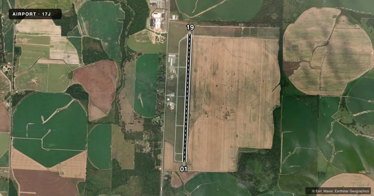
Airport sketch
Runways drawn to scale from FAA survey coordinates, rendered over satellite imagery. Not for navigation.
Approaches & charts
Services on the field
Fuel grades, oxygen, maintenance, ramp storage and lighting — as declared to the FAA by the airport operator.
Fuel & services
- Fuel
- 100LL
- Oxygen (bottled)
- Not available
- Oxygen (bulk)
- Not available
- Airframe repair
- Not available
- Power plant repair
- Not available
- Other services
- AGRI
Ramp & ground
- Transient storage
- Tie-down
- Hangar
- Landing fee
- No fee published
- Customs
- Not available
- Lighting schedule
- SEE RMK
- Beacon schedule
- SS-SR
- Beacon
- White / Green (civil land)(WG)
- Wind indicator
- Lighted
- Segmented circle
- Yes
Fuel & FBOs
Cheapest 100LL and Jet A on the field and nearby. Always confirm with the FBO before taxi.
Airport notes
Surface conditions, obstructions, local procedures, lighting outages and other notes published with each FAA cycle.
General notes
- FOR CD CTC CAIRNS APCH AT 334-255-8402, WHEN APCH CLSD CTC JACKSONVILLE ARTCC AT 904-845-1592.
Lighting notes
- ACTVT MIRL RWY 01/19 - CTAF. PAPI RWY 01/19 OPR CONSLY DUSK - 2300, AFT 2300 - CTAF.
Fuel notes
- 100LLFUEL 24 HR CREDIT CARD SVC AVBL.
Other notes
- EXISTED PRIOR TO 1959.
- OWNERAIRPORT COMMISSION
VFR map & nearby airports
VFR sectional. Tap any ICAO chip to open that airport.
Key facts · 17J
Answer card- ICAO
- 17J
- Name
- DONALSONVILLE MUNI
- Location
- DONALSONVILLE, GEORGIA
- Elevation
- 147.4 ft MSL
- Traffic pattern altitude
- 1,147.4 ft MSL (1,000 AGL)
- Control tower
- Non-towered (use CTAF)
- Total runways
- 1
- Longest runway
- 01/19 · 5,512 ft
- Published ILS approaches
- 0
- Published frequencies
- 3
- Magnetic variation
- 5°
- Current flight rules
- VFR
- Current wind
- 280° at 5 kt
- Favored runway now
- RWY 01
Donalsonville Muni is in Donalsonville, Georgia. Field elevation is 147.4 ft MSL. The airport has one runway. Runway 01/19 is 5,512 ft long with asphalt pavement. There is no control tower. Traffic pattern altitude is not published, so use the standard 1,000 ft AGL for light piston traffic unless the current Chart Supplement says otherwise.
No ILS approaches are published here. For clearance delivery, contact Cairns Approach. When Cairns Approach is closed, use Jacksonville ARTCC. CTAF is 122.9. The airport carries 100LL through Donalsonville Municipal Airport. Fuel is available 24 hours with credit card service. The runway lights on 01/19 are pilot-controlled on CTAF. The PAPI on 01/19 runs continuously from dusk to 2300. After 2300, it is also activated by CTAF.
This is a low-elevation field with a single runway, so plan for standard local pattern work and normal self-announce traffic flow. The airport sits in southwest Georgia near the Florida line. Check the current FAA Chart Supplement for any published noise or operational notes before you go.