METAR & TAF KBIJ
Current METAR
Observed 11:55Z
KBIJ 271155Z AUTO 00000KT 10SM CLR 23/22 A2993 RMK AO2
- Wind
- 000° @ 0 kt
- Visibility
- 10 SM
- Temp / Dew
- 23°C / 22°C
- Altimeter
- 29.93 inHg
- Clouds
- CLR
- Density alt
- 1,214 ft
- Ceiling
- Unlimited
- Rules
- VFR
Airport info & contacts
Manager on record, flight service, ARTCC, attendance schedule and pattern altitude — published by the FAA and refreshed every 28 days.
Location
- From city
- 3 NM E
- VFR sectional
- JACKSONVILLE
- Pattern altitude
- 987 ft AGL · 1,202 ft MSL
- ARTCC
- ZJX · JACKSONVILLE
- NOTAM facility
- MCN (NOTAM-D)
Airport manager
- Name
- STEPHANIE CHANDLER
- Phone
- 229-723-4304
- Address
- 204 COURT SQUARE, BLAKELY GA 39823
Flight service · Hours
- FSS MCN
- MACON1-800-WX-BRIEF
- Attendance
- MON-FRI · 0800-1600
Frequencies
Tap any row to copy the frequency to your clipboard.
Runways & pattern
Full pagePattern entry · RWY 05
LEFT TRAFFICRunway end performance
| End | TORA | TODA | ASDA | LDA | VGSI | Approach lights | Obstruction |
|---|---|---|---|---|---|---|---|
| 05 | — | — | — | — | PAPI 2-box left(3°) | — | 96', trees, 2792' from thr, 480' R of cntrln, slope 27 |
| 23 | — | — | — | — | PAPI 2-box left(3°) | MALSF | 82', trees, 1430' from thr, 336' R of cntrln, slope 15 |
Declared distances in feet. TORA = takeoff run available, TODA = takeoff distance, ASDA = accelerate-stop, LDA = landing distance.
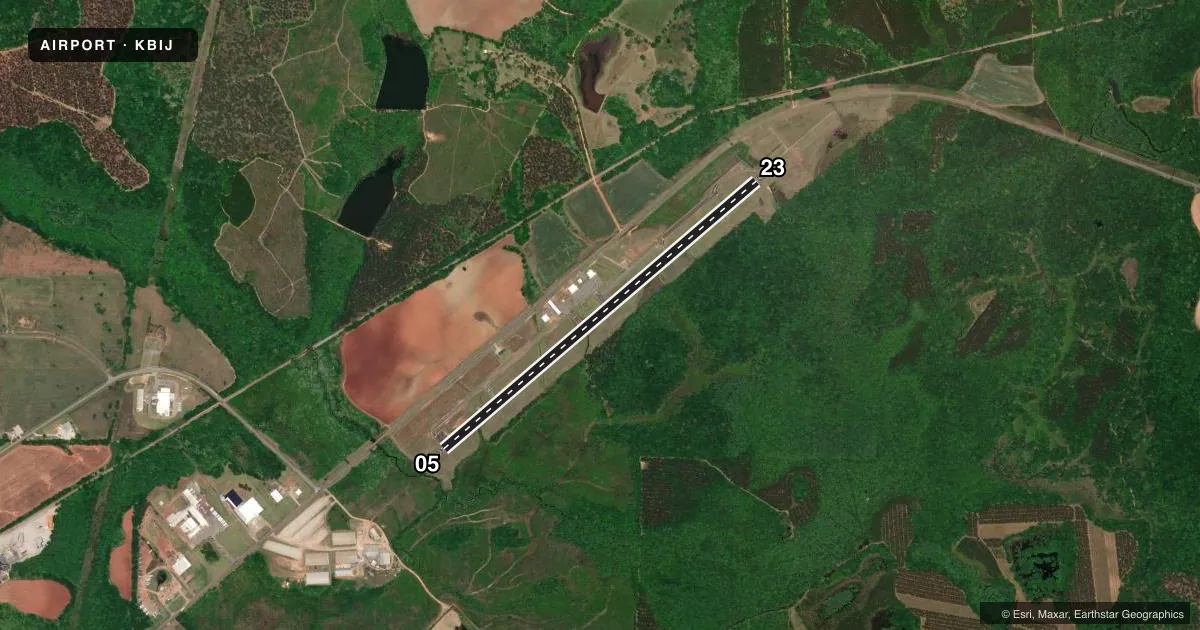
Airport sketch
Runways drawn to scale from FAA survey coordinates, rendered over satellite imagery. Not for navigation.
Approaches & charts
Services on the field
Fuel grades, oxygen, maintenance, ramp storage and lighting — as declared to the FAA by the airport operator.
Fuel & services
- Fuel
- 100LLA
- Oxygen (bottled)
- Not available
- Oxygen (bulk)
- Not available
- Airframe repair
- Not available
- Power plant repair
- Not available
- Other services
- AGRI
Ramp & ground
- Transient storage
- Tie-down
- Hangar
- Landing fee
- No fee published
- Customs
- Not available
- Lighting schedule
- SEE RMK
- Beacon schedule
- SS-SR
- Beacon
- White / Green (civil land)(WG)
- Wind indicator
- Lighted
- Segmented circle
- Yes
Fuel & FBOs
Cheapest 100LL and Jet A on the field and nearby. Always confirm with the FBO before taxi.
Airport notes
Surface conditions, obstructions, local procedures, lighting outages and other notes published with each FAA cycle.
General notes
- FOR CD CTC JACKSONVILLE ARTCC AT 904-845-1592.
Lighting notes
- ACTVT MALSF RWY 23; PAPI RWYS 05 & 23; MIRL RWY 05/23 - CTAF.
Other notes
- TSNT HNGR IS SHADE HNGR.
VFR map & nearby airports
VFR sectional. Tap any ICAO chip to open that airport.
Key facts · KBIJ
Answer card- ICAO
- KBIJ
- Name
- EARLY COUNTY
- Location
- BLAKELY, GEORGIA
- Elevation
- 214.6 ft MSL
- Traffic pattern altitude
- 1,201.6 ft MSL (987 AGL)
- Control tower
- Non-towered (use CTAF)
- Total runways
- 1
- Longest runway
- 05/23 · 5,494 ft
- Published ILS approaches
- 0
- Published frequencies
- 3
- Magnetic variation
- 3°
- Current flight rules
- VFR
- Current wind
- 000° at 0 kt
- Favored runway now
- –
Early County Airport sits in Blakely, Georgia. The field elevation is 214.6 ft MSL. It has one runway, 05/23, which is 5,494 ft long. There is no control tower. Use CTAF 122.9 for local traffic. The published pattern altitude is 987 ft AGL, which is 1,201.6 ft MSL.
No ILS approaches are published here. The airport does have medium intensity runway lights on 05/23. Runway 23 also has a medium intensity approach lighting system with sequenced flashers. PAPI is installed on both runway ends. That helps on a night or low-ceiling arrival. The transient hangar is a shade hangar.
Early County Airport is on the field and carries AVGAS 100LL and Jet A. Call the airport at (229) 723-4304 for current service details. For clearance delivery, contact Jacksonville ARTCC at 904-845-1592. Pilots should plan for an uncontrolled field with standard CTAF self-announce traffic. Check the current FAA Chart Supplement for any noise or local operating notes before you go. The runway length is workable for a lot of GA traffic. Still, confirm performance if you are heavy or dealing with summer density altitude.