METAR & TAF KEUF
Current METAR
Observed 09:58Z
KEUF 270958Z AUTO 00000KT 10SM CLR 25/24 A2991 RMK AO1 SLP122 T02500244 $
- Wind
- 000° @ 0 kt
- Visibility
- 10 SM
- Temp / Dew
- 25°C / 24°C
- Altimeter
- 29.91 inHg
- Clouds
- CLR
- Density alt
- 1,566 ft
- Ceiling
- Unlimited
- Rules
- VFR
Airport info & contacts
Manager on record, flight service, ARTCC, attendance schedule and pattern altitude — published by the FAA and refreshed every 28 days.
Location
- From city
- 3 NM N
- VFR sectional
- NEW ORLEANS
- ARTCC
- ZTL · ATLANTA
- NOTAM facility
- ANB (NOTAM-D)
Airport manager
- Name
- NIKKI OGLETREE
- Phone
- 334-695-0285
- Address
- 1730 N. EUFALA AVE, EUFAULA AL 36027
Flight service · Hours
- FSS ANB
- ANNISTON1-800-WX-BRIEF
- Attendance
- MON- FRI · 0800-1700
- SAT-SUN · 0830-1500
Frequencies
Tap any row to copy the frequency to your clipboard.
Runways & pattern
Full pagePattern entry · RWY 18
LEFT TRAFFICRunway end performance
| End | TORA | TODA | ASDA | LDA | VGSI | Approach lights | Obstruction |
|---|---|---|---|---|---|---|---|
| 18 | — | — | — | — | PAPI 4-box left(3°) | — | 24', tree, 314' from thr, 98' R of cntrln, slope 4 |
| 36 | — | — | — | — | PAPI 4-box left(3°) | — | 26', tree, 222' from thr, 220' R of cntrln, slope 0 |
Declared distances in feet. TORA = takeoff run available, TODA = takeoff distance, ASDA = accelerate-stop, LDA = landing distance.
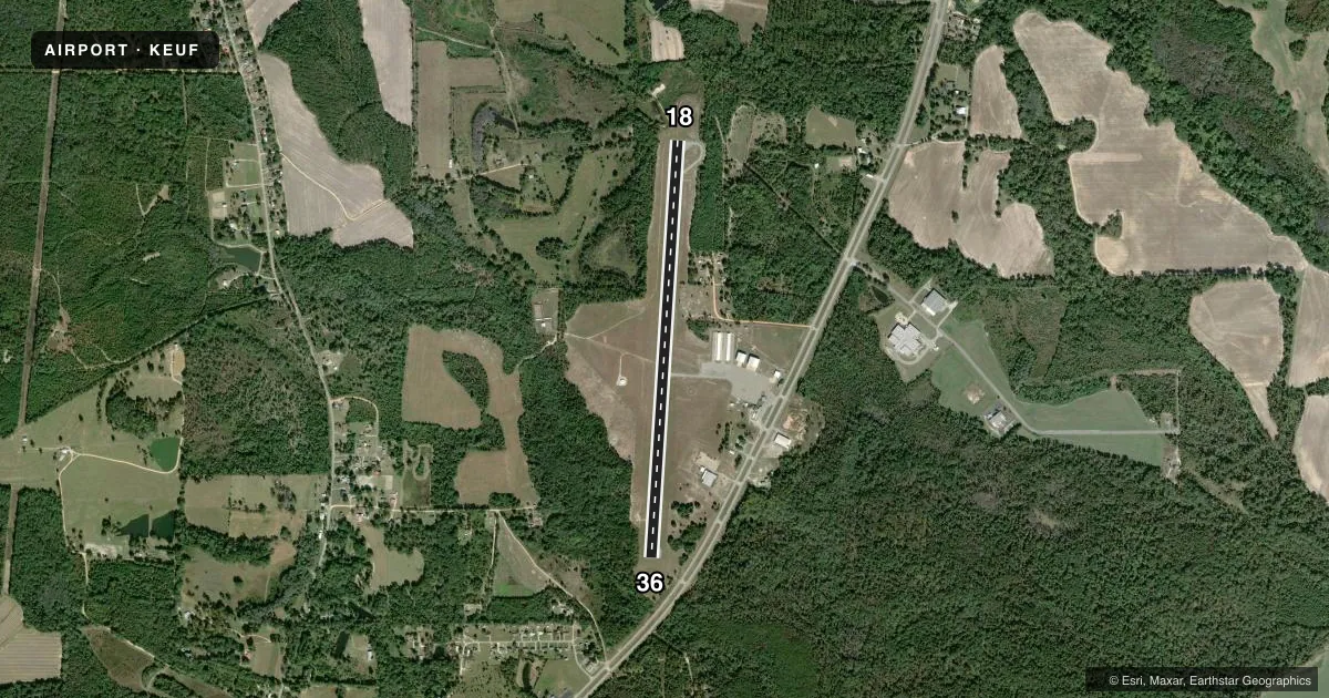
Airport sketch
Runways drawn to scale from FAA survey coordinates, rendered over satellite imagery. Not for navigation.
Approaches & charts
Services on the field
Fuel grades, oxygen, maintenance, ramp storage and lighting — as declared to the FAA by the airport operator.
Fuel & services
- Fuel
- 100LLA+
- Oxygen (bottled)
- Not available
- Oxygen (bulk)
- Not available
- Airframe repair
- Not available
- Power plant repair
- Not available
- Other services
- INSTR,RNTL
Ramp & ground
- Transient storage
- Tie-down
- Hangar
- Landing fee
- No fee published
- Customs
- Not available
- Lighting schedule
- SEE RMK
- Beacon schedule
- SS-SR
- Beacon
- White / Green (civil land)(WG)
- Wind indicator
- Lighted
- Segmented circle
- Yes
Fuel & FBOs
Cheapest 100LL and Jet A on the field and nearby. Always confirm with the FBO before taxi.
Airport notes
Surface conditions, obstructions, local procedures, lighting outages and other notes published with each FAA cycle.
General notes
- LOW FLYING HELICOPTERS IN TFC PAT.
- ARPT LCTD IN WILDLIFE REFUGE - CONSTANT BIRD HAZARD.
Lighting notes
- DUSK-2200. AFTER 2200, ACTVT PAPI RWYS 18 & 36; MIRL RWY 18/36 - CTAF.
Approach & departure obstructions
- 18CONTROLLING OBSTRUCTION EXCEEDS A 45 DEGREE SLOPE
Other notes
- 1MON- FRI
- 1FOR SVC AFT HRS CALL 334-695-0285.
- MANAGER334-695-0285 AFT HRS.
VFR map & nearby airports
VFR sectional. Tap any ICAO chip to open that airport.
Key facts · KEUF
Answer card- ICAO
- KEUF
- Name
- WEEDON FLD
- Location
- EUFAULA, ALABAMA
- Elevation
- 285.2 ft MSL
- Traffic pattern altitude
- 1,285.2 ft MSL (1,000 AGL)
- Control tower
- Non-towered (use CTAF)
- Total runways
- 1
- Longest runway
- 18/36 · 5,000 ft
- Published ILS approaches
- 0
- Published frequencies
- 8
- Magnetic variation
- 4°
- Current flight rules
- VFR
- Current wind
- 000° at 0 kt
- Favored runway now
- –
Weedon Fld sits in Eufaula, Alabama. The field elevation is 285.2 ft MSL. It has one runway. Runway 18/36 is 5,000 ft of asphalt, so it is the runway to plan around. There is no control tower. The airport is attended Monday through Friday. For after-hours service, call the manager at the number in the Chart Supplement.
No ILS approaches are published here. Pattern altitude is not published, so use the standard 1,000 ft AGL for light piston traffic unless the current Chart Supplement says otherwise. That puts the pattern at about 1,285 ft MSL based on the field elevation. The airport uses CTAF 122.8. UNICOM is also 122.8.
Eufaula Jet Center is on the field. It carries 100LL and Jet A. Published remarks matter here. The airport sits in a wildlife refuge, so bird activity is a real factor. Low flying helicopters also work the pattern. Runway 18 has a controlling obstruction that exceeds a 45 degree slope. Lighting is also worth planning for. From dusk to 2200, the PAPI and medium intensity runway lights on 18/36 are activated by using the CTAF. After 2200, use the CTAF to activate them before arrival.