METAR & TAF 11A
11A does not publish a METAR.
Showing the nearest reporting station: KEUF (WEEDON FLD) · 18.6 NM away. Conditions at 11A may differ.
METAR · KEUF
Observed 14:58Z
KEUF 251458Z AUTO VRB04KT 10SM FEW045 31/24 A3013 RMK AO1 RAE41 SLP196 P0000 60000 T03060244 50001
- Wind
- VAR @ 4 kt
- Visibility
- 10 SM
- Temp / Dew
- 31°C / 24°C
- Altimeter
- 30.13 inHg
- Clouds
- FEW
- Density alt
- 2,199 ft
- Ceiling
- Unlimited
- Rules
- VFR
Airport info & contacts
Manager on record, flight service, ARTCC, attendance schedule and pattern altitude — published by the FAA and refreshed every 28 days.
Location
- From city
- 2 NM W
- VFR sectional
- NEW ORLEANS
- ARTCC
- ZJX · JACKSONVILLE
- NOTAM facility
- ANB (NOTAM-D)
Airport manager
- Name
- DARRELL BYRD
- Phone
- 334-232-1028
- Address
- 25 ROBERTSON AIRPORT RD., CLAYTON AL 36016
Flight service · Hours
- FSS ANB
- ANNISTON1-800-WX-BRIEF
- Attendance
- Unattended
Frequencies
Tap any row to copy the frequency to your clipboard.
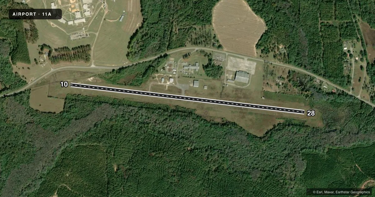
Runways & pattern
Full pagePattern entry · RWY 28
LEFT TRAFFICRunway end performance
| End | TORA | TODA | ASDA | LDA | VGSI | Approach lights | Obstruction |
|---|---|---|---|---|---|---|---|
| 10 | — | — | — | — | PAPI 2-box left(3.2°) | — | 53', tree, 1106' from thr, 178' R of cntrln, slope 17 |
| 28 | — | — | — | — | PAPI 2-box left(3.75°) | — | 85', tree, 1203' from thr, 293' R of cntrln, slope 11 |
Declared distances in feet. TORA = takeoff run available, TODA = takeoff distance, ASDA = accelerate-stop, LDA = landing distance.
Airport sketch
Runways drawn to scale from FAA survey coordinates, rendered over satellite imagery. Not for navigation.
Approaches & charts
Services on the field
Fuel grades, oxygen, maintenance, ramp storage and lighting — as declared to the FAA by the airport operator.
Fuel & services
- Fuel
- Not available
- Oxygen (bottled)
- Not available
- Oxygen (bulk)
- Not available
- Airframe repair
- Not available
- Power plant repair
- Not available
Ramp & ground
- Transient storage
- Tie-down
- Landing fee
- No fee published
- Lighting schedule
- SEE RMK
- Beacon schedule
- SS-SR
- Beacon
- White / Green (civil land)(WG)
- Wind indicator
- Lighted
- Segmented circle
- Yes
Fuel & FBOs
Cheapest 100LL and Jet A on the field and nearby. Always confirm with the FBO before taxi.
Airport notes
Surface conditions, obstructions, local procedures, lighting outages and other notes published with each FAA cycle.
General notes
- DEER AND BIRD ACTVTY ON AND INVOF RWY.
- FOR CD CTC CAIRNS APCH AT 334-255-8402; FOR CD WHEN CAIRNS APCH CLSD CTC ATLANTA ARTCC AT 770-210-7692.
Lighting notes
- ACTVT PAPI RWY 10 & 28; REIL RWY 10 & 28; HIRL RWY 10/28 - CTAF.
Approach & departure obstructions
- 10APCH RATIO 19:1 FM DSPLCD THR.
Other notes
- VFR ONLY
VFR map & nearby airports
VFR sectional. Tap any ICAO chip to open that airport.
Key facts · 11A
Answer card- ICAO
- 11A
- Name
- CLAYTON MUNI
- Location
- CLAYTON, ALABAMA
- Elevation
- 434.9 ft MSL
- Traffic pattern altitude
- 1,434.9 ft MSL (1,000 AGL)
- Control tower
- Non-towered (use CTAF)
- Total runways
- 1
- Longest runway
- 10/28 · 5,010 ft
- Published ILS approaches
- 0
- Published frequencies
- 3
- Magnetic variation
- 4°
- Current flight rules
- VFR
- Current wind
- 000° at 4 kt
- Favored runway now
- RWY 28
Clayton Muni sits in Clayton, Alabama. The field elevation is 434.9 ft MSL. It has one runway. The longest runway is 5,010 ft of asphalt. There is no control tower. Cairns Approach handles clearance delivery. Published remarks say the field is VFR only, so plan for visual operations only. No ILS approaches are published here.
The pattern altitude is not published. Use the standard 1,000 ft AGL for light piston traffic unless the current Chart Supplement says otherwise. Runway lighting is pilot controlled on CTAF. PAPI and REIL are available on both ends of runway 10/28. The published remarks also call out deer and bird activity near the runway, so keep a sharp scan on arrival and departure. There is also a note about the approach ratio from the displaced threshold on runway 10. If you are planning a first visit, verify the current remarks before you go. This is a small non-towered field with one runway. Expect straightforward traffic flow. Stay alert for wildlife and local VFR traffic.