METAR & TAF 25J
25J does not publish a METAR.
Showing the nearest reporting station: KBIJ (EARLY COUNTY) · 18.6 NM away. Conditions at 25J may differ.
METAR · KBIJ
Observed 03:35Z
KBIJ 270335Z AUTO 00000KT 10SM CLR 25/23 A2995 RMK AO2
- Wind
- 000° @ 0 kt
- Visibility
- 10 SM
- Temp / Dew
- 25°C / 23°C
- Altimeter
- 29.95 inHg
- Clouds
- CLR
- Density alt
- 1,733 ft
- Ceiling
- Unlimited
- Rules
- VFR
Airport info & contacts
Manager on record, flight service, ARTCC, attendance schedule and pattern altitude — published by the FAA and refreshed every 28 days.
Location
- From city
- 4 NM SW
- VFR sectional
- JACKSONVILLE
- ARTCC
- ZJX · JACKSONVILLE
- NOTAM facility
- MCN (NOTAM-D)
Airport manager
- Name
- BILLY MOORE
- Phone
- 229-869-6102
- Address
- 331 MOORE ROAD, COLEMAN GA 39836
Flight service · Hours
- FSS MCN
- MACON1-800-WX-BRIEF
- Attendance
- Unattended
Frequencies
Tap any row to copy the frequency to your clipboard.
Runways & pattern
Full pagePattern entry · RWY 18
LEFT TRAFFICRunway end performance
| End | TORA | TODA | ASDA | LDA | VGSI | Approach lights | Obstruction |
|---|---|---|---|---|---|---|---|
| 18 | — | — | — | — | — | — | 76', trees, 1188' from thr, 134' R of cntrln, slope 13 |
Declared distances in feet. TORA = takeoff run available, TODA = takeoff distance, ASDA = accelerate-stop, LDA = landing distance.
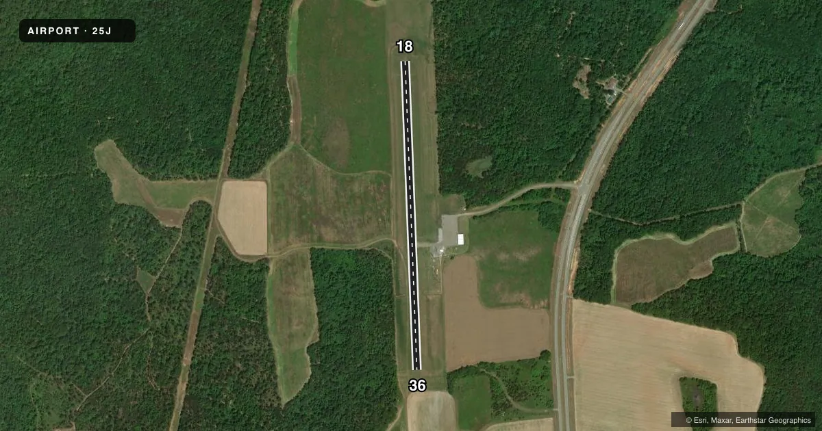
Airport sketch
Runways drawn to scale from FAA survey coordinates, rendered over satellite imagery. Not for navigation.
Approaches & charts
Services on the field
Fuel grades, oxygen, maintenance, ramp storage and lighting — as declared to the FAA by the airport operator.
Fuel & services
- Fuel
- Not available
- Oxygen (bottled)
- Not available
- Oxygen (bulk)
- Not available
- Airframe repair
- Not available
- Power plant repair
- Not available
- Other services
- AGRI
Ramp & ground
- Transient storage
- Tie-down
- Landing fee
- No fee published
- Customs
- Not available
- Lighting schedule
- SEE RMK
- Beacon schedule
- SS-SR
- Beacon
- White / Green (civil land)(WG)
- Wind indicator
- Yes
- Segmented circle
- Yes
Fuel & FBOs
Cheapest 100LL and Jet A on the field and nearby. Always confirm with the FBO before taxi.
Airport notes
Surface conditions, obstructions, local procedures, lighting outages and other notes published with each FAA cycle.
General notes
- DEER FRQLY ON AND INVOF ARPT.
- FOR CD CTC JACKSONVILLE ARTCC AT 904-845-1592.
Lighting notes
- ACTVT REIL RWY 18 & 36; MIRL RWY 18/36 - CTAF.
Approach & departure obstructions
- 1814:1 APPRCH TO DISP THRESH DUE TO 52' TALL TREE, 728 FROM THRESH, 204' RIGHT
VFR map & nearby airports
VFR sectional. Tap any ICAO chip to open that airport.
Key facts · 25J
Answer card- ICAO
- 25J
- Name
- RANDOLPH COUNTY
- Location
- CUTHBERT, GEORGIA
- Elevation
- 459.9 ft MSL
- Traffic pattern altitude
- 1,459.9 ft MSL (1,000 AGL)
- Control tower
- Non-towered (use CTAF)
- Total runways
- 1
- Longest runway
- 18/36 · 3,000 ft
- Published ILS approaches
- 0
- Published frequencies
- 1
- Magnetic variation
- 1°
- Current flight rules
- VFR
- Current wind
- 000° at 0 kt
- Favored runway now
- –
Randolph County Airport sits in Cuthbert, Georgia. The field elevation is 459.9 ft MSL. It has one runway, 18/36, which is 3,000 ft long and paved. There is no control tower. CTAF is 122.9.
No ILS approaches are published here. Pattern altitude is not published in the facts, so use the standard 1,000 ft AGL for light piston traffic unless the current FAA Chart Supplement says otherwise. The runway lighting is pilot controlled on CTAF. Runway end identifier lights are also installed on 18 and 36.
For a first-time arrival, pay attention to the published obstruction note on runway 18. There is a 52 ft tree near the threshold that drives a 14 to 1 approach slope to the displaced threshold. Deer are frequently on and near the airport, so keep a sharp scan on base and final. If you need clearance delivery, contact Jacksonville ARTCC at 904-845-1592. There are no on-field FBOs listed, so verify fuel and services with the airport operator or the field directly before you go.