METAR & TAF 79J
Current METAR
Observed 12:56Z
K79J 271256Z AUTO 32005KT 10SM SCT039 SCT055 BKN070 27/24 A2996 RMK AO2 SLP140 T02670239 TSNO
- Wind
- 320° @ 5 kt
- Visibility
- 10 SM
- Temp / Dew
- 27°C / 24°C
- Altimeter
- 29.96 inHg
- Clouds
- BKN
- Density alt
- 1,775 ft
- Ceiling
- 7,000 ft AGL
- Rules
- VFR
Airport info & contacts
Manager on record, flight service, ARTCC, attendance schedule and pattern altitude — published by the FAA and refreshed every 28 days.
Location
- From city
- 4 NM E
- VFR sectional
- NEW ORLEANS
- ARTCC
- ZJX · JACKSONVILLE
- NOTAM facility
- 79J (NOTAM-D)
Airport manager
- Name
- JED BLACKWELL
- Phone
- 334-222-6598
- Address
- 21861 BILL BENTON LANE, ANDALUSIA AL 36421
Flight service · Hours
- FSS ANB
- ANNISTON1-800-WX-BRIEF
- Attendance
- SAT-SUN · 0730-1630
- MON - FRI · 0630-0000
Frequencies
Tap any row to copy the frequency to your clipboard.
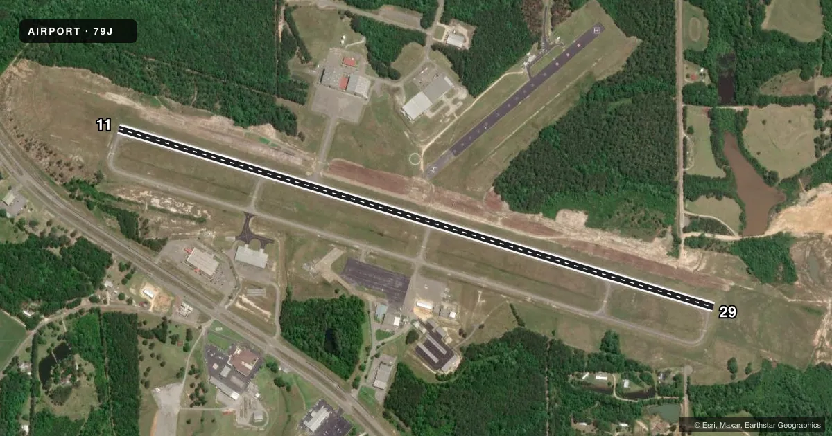
Runways & pattern
Full pagePattern entry · RWY 29
LEFT TRAFFICRunway end performance
| End | TORA | TODA | ASDA | LDA | VGSI | Approach lights | Obstruction |
|---|---|---|---|---|---|---|---|
| 11 | — | — | — | — | PAPI 4-box right(3°) | — | 102', tree, 2795' from thr, 100' R of cntrln, slope 25 |
| 29 | — | — | — | — | PAPI 4-box left(3.5°) | — | 54', tree, 1535' from thr, 176' R of cntrln, slope 24 |
Declared distances in feet. TORA = takeoff run available, TODA = takeoff distance, ASDA = accelerate-stop, LDA = landing distance.
Airport sketch
Runways drawn to scale from FAA survey coordinates, rendered over satellite imagery. Not for navigation.
Approaches & charts
Services on the field
Fuel grades, oxygen, maintenance, ramp storage and lighting — as declared to the FAA by the airport operator.
Fuel & services
- Fuel
- 100LLA+
- Oxygen (bottled)
- Not available
- Oxygen (bulk)
- Not available
- Airframe repair
- Major
- Power plant repair
- Major
- Other services
- INSTR
Ramp & ground
- Transient storage
- Tie-down
- Landing fee
- No fee published
- Customs
- Not available
- Lighting schedule
- SEE RMK
- Beacon schedule
- SS-SR
- Beacon
- White / Green (civil land)(WG)
- Wind indicator
- Lighted
- Segmented circle
- Yes
Fuel & FBOs
Cheapest 100LL and Jet A on the field and nearby. Always confirm with the FBO before taxi.
Airport notes
Surface conditions, obstructions, local procedures, lighting outages and other notes published with each FAA cycle.
General notes
- FOR CD CTC CAIRNS APCH AT 334-255-8402, WHEN APCH CLSD CTC JACKSONVILLE ARTCC AT 904-845-1592.
Lighting notes
- ACTVT PAPI RWY 11 & 29; MIRL RWY 11/29 - CTAF.
Fuel notes
- 100LL100LL SELF SERVE AVBL 24 HRS.
- A+MILITARY CONTRACT FUEL AVBL MON-FRI 0700-2400, OTHER TIMES CALL (334) 222-0638
Approach & departure obstructions
- 11MARKINGS FAIR DUE TO FADING
Other notes
- THIS AIRPORT HAS BEEN SURVEYED BY THE NATIONAL GEODETIC SURVEY.
- 4AFT HRS SVC CALL 334-222-0638/334-427-0733
- MANAGERJED BLACKWELL
VFR map & nearby airports
VFR sectional. Tap any ICAO chip to open that airport.
Key facts · 79J
Answer card- ICAO
- 79J
- Name
- SOUTH ALABAMA RGNL AT BILL BENTON FLD
- Location
- ANDALUSIA, ALABAMA
- Elevation
- 310.2 ft MSL
- Traffic pattern altitude
- 1,310.2 ft MSL (1,000 AGL)
- Control tower
- Non-towered (use CTAF)
- Total runways
- 1
- Longest runway
- 11/29 · 6,000 ft
- Published ILS approaches
- 0
- Published frequencies
- 4
- Magnetic variation
- 2°
- Current flight rules
- VFR
- Current wind
- 320° at 5 kt
- Favored runway now
- RWY 29
South Alabama Rgnl at Bill Benton Fld sits in Andalusia, Alabama. Field elevation is 310.2 ft MSL. The airport has one runway. Runway 11/29 is 6,000 ft asphalt. Runway headings are 107° and 287° magnetic. There is no control tower. Pattern altitude is not published, so use 1,000 ft AGL for light piston traffic unless current local guidance says otherwise.
No ILS approaches are published here. For clearance delivery, contact Cairns Approach at 334-255-8402. When Approach is closed, contact Jacksonville ARTCC at 904-845-1592. CTAF and UNICOM are both 123.05. The field has PAPI on both runway ends. Medium intensity runway lights are controlled by CTAF. Runway 11 markings are reported as fair due to fading, so give yourself a little extra attention on rollout and lineup.
South Alabama Regional Airport is the on-field FBO. It carries 100LL and Jet A. 100LL self-serve fuel is available 24 hours. Military contract fuel is available Monday through Friday from 0700 to 2400. If you need after-hours service, call the numbers in the Chart Supplement before you launch. This is a non-towered field. Plan your arrival, listen early and verify the current airport remarks before you go.