METAR & TAF KALX
Current METAR
Observed 07:15Z
KALX 270715Z AUTO 18001KT 4SM BR CLR 25/25 A2994 RMK AO2 LTG DSNT E
- Wind
- 180° @ 1 kt
- Visibility
- 4 SM
- Temp / Dew
- 25°C / 25°C
- Altimeter
- 29.94 inHg
- Clouds
- CLR
- Density alt
- 2,026 ft
- Ceiling
- Unlimited
- Rules
- MVFR
Airport info & contacts
Manager on record, flight service, ARTCC, attendance schedule and pattern altitude — published by the FAA and refreshed every 28 days.
Location
- From city
- 2 NM SW
- VFR sectional
- ATLANTA
- ARTCC
- ZTL · ATLANTA
- NOTAM facility
- ALX (NOTAM-D)
Airport manager
- Name
- JACKSON HATTON
- Phone
- 256-329-9057
- Address
- 965 T.C. RUSSELL FIELD, ALEXANDER CITY AL 35010
Flight service · Hours
- FSS ANB
- ANNISTON1-800-WX-BRIEF
- Attendance
- MON-FRI · 0800-1700
Frequencies
Tap any row to copy the frequency to your clipboard.
Runways & pattern
Full pagePattern entry · RWY 18
LEFT TRAFFICRunway end performance
| End | TORA | TODA | ASDA | LDA | VGSI | Approach lights | Obstruction |
|---|---|---|---|---|---|---|---|
| 18 | — | — | — | — | PAPI 4-box left(3°) | — | 129', tree, 2006' from thr, 572' R of cntrln, slope 15 |
| 36 | — | — | — | — | PAPI 4-box left(3°) | — | 46', tree, 1117' from thr, 347' R of cntrln, slope 19 |
Declared distances in feet. TORA = takeoff run available, TODA = takeoff distance, ASDA = accelerate-stop, LDA = landing distance.
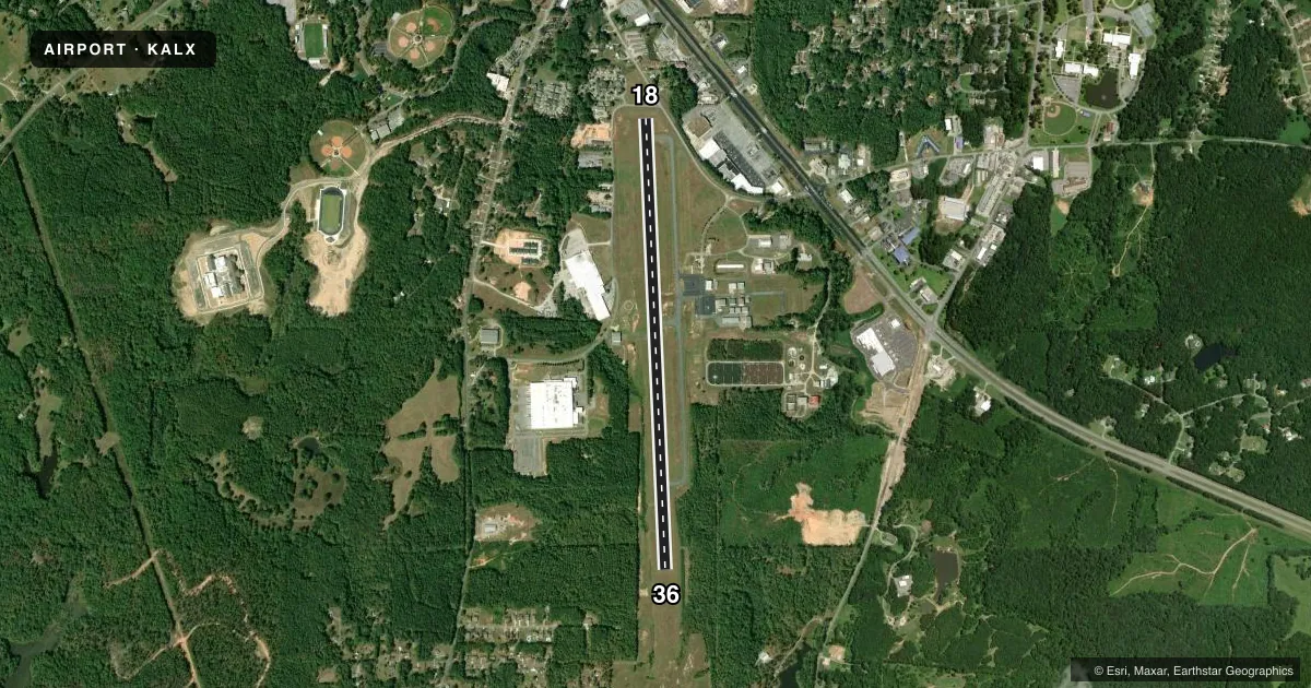
Airport sketch
Runways drawn to scale from FAA survey coordinates, rendered over satellite imagery. Not for navigation.
Approaches & charts
Services on the field
Fuel grades, oxygen, maintenance, ramp storage and lighting — as declared to the FAA by the airport operator.
Fuel & services
- Fuel
- 100LLA
- Oxygen (bottled)
- Not available
- Oxygen (bulk)
- Not available
- Airframe repair
- Not available
- Power plant repair
- Not available
- Other services
- INSTR,RNTL
Ramp & ground
- Transient storage
- Tie-down
- Landing fee
- No fee published
- Customs
- Not available
- Lighting schedule
- SEE RMK
- Beacon schedule
- SS-SR
- Beacon
- White / Green (civil land)(WG)
- Wind indicator
- Lighted
- Segmented circle
- Yes
Fuel & FBOs
Cheapest 100LL and Jet A on the field and nearby. Always confirm with the FBO before taxi.
Airport notes
Surface conditions, obstructions, local procedures, lighting outages and other notes published with each FAA cycle.
General notes
- TWY LGTS FOR TWY TURNOFF ONLY.
- FOR CD CTC MONTGOMERY APCH AT 334-284-4575. WHEN APCH CLSD FOR CD CTC ATLANTA ARTCC AT 770-210-7692.
Lighting notes
- ACTVT REIL RWY 36; MIRL RWY 18/36 - CTAF.
Fuel notes
- 100LL24 HR CREDIT CARD SVC BOTH JET-A AND AVGAS.
Approach & departure obstructions
- 18PAPI UNUSBL BYD 5 DEG LEFT AND 6 DEG RIGHT OF CNTRLN.
- 36PAPI UNUSBL BYD 6 DEG LEFT OF CNTRLN.
- 18APCH RATIO 15:1 FM DSPLCD THR.
Other notes
- MANAGERON CALL 256-392-2452.
VFR map & nearby airports
VFR sectional. Tap any ICAO chip to open that airport.
Key facts · KALX
Answer card- ICAO
- KALX
- Name
- THOMAS C RUSSELL FLD
- Location
- ALEXANDER CITY, ALABAMA
- Elevation
- 685.8 ft MSL
- Traffic pattern altitude
- 1,685.8 ft MSL (1,000 AGL)
- Control tower
- Non-towered (use CTAF)
- Total runways
- 1
- Longest runway
- 18/36 · 5,422 ft
- Published ILS approaches
- 0
- Published frequencies
- 4
- Magnetic variation
- 4°
- Current flight rules
- MVFR
- Current wind
- 180° at 1 kt
- Favored runway now
- RWY 18
Thomas C Russell Fld sits in Alexander City, Alabama. The field elevation is 685.8 ft MSL. It has one runway, 18/36, which is 5,422 ft long and asphalt. There is no control tower. Pattern altitude is not published. Use the standard 1,000 ft AGL pattern for light piston traffic unless current local guidance says otherwise. No ILS approaches are published here.
Alexander City Flying Service is on the field. It carries 100LL and Jet-A Prist. Twenty-four hour credit card service is available for both Avgas and Jet-A. The airport is served by CTAF 122.7 and UNICOM 122.7. Montgomery Approach handles approach and departure on 121.2 and 269.05. For clearance delivery, contact Montgomery Approach. If approach is closed, clearance delivery goes through Atlanta ARTCC.
A few published remarks matter here. Runway 36 has REIL lighting. Runways 18 and 36 have medium intensity runway lighting controlled by CTAF. The PAPI on runway 18 is unusable beyond 5 degrees left and 6 degrees right of centerline. The PAPI on runway 36 is unusable beyond 6 degrees left of centerline. Taxiway lights are for taxiway turnoff only. Runway 18 also has a 15 to 1 approach slope ratio from the displaced threshold. This is a non-towered field. Plan your arrival, monitor CTAF closely and verify current procedures with the airport operator if you need anything beyond the published remarks.