METAR & TAF 26A
26A does not publish a METAR.
Showing the nearest reporting station: KANB (ANNISTON RGNL) · 18.4 NM away. Conditions at 26A may differ.
METAR · KANB
Observed 18:05Z
KANB 261805Z AUTO 00000KT 10SM FEW024 BKN031 30/24 A3001 RMK AO2 T03000239 $
- Wind
- 000° @ 0 kt
- Visibility
- 10 SM
- Temp / Dew
- 30°C / 24°C
- Altimeter
- 30.01 inHg
- Clouds
- BKN
- Density alt
- 3,009 ft
- Ceiling
- 3,100 ft AGL
- Rules
- VFR
Airport info & contacts
Manager on record, flight service, ARTCC, attendance schedule and pattern altitude — published by the FAA and refreshed every 28 days.
Location
- From city
- 2 NM NE
- VFR sectional
- ATLANTA
- ARTCC
- ZTL · ATLANTA
- NOTAM facility
- ANB (NOTAM-D)
Airport manager
- Name
- MARK BRERETON
- Phone
- 706-506-8638
- Address
- 375 AIRPORT ROAD, ASHLAND AL 36251
Flight service · Hours
- FSS ANB
- ANNISTON1-800-WX-BRIEF
- Attendance
- Unattended
Frequencies
Tap any row to copy the frequency to your clipboard.
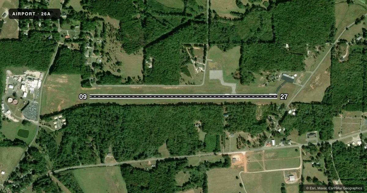
Runways & pattern
Full pagePattern entry · RWY 09
LEFT TRAFFICRunway end performance
| End | TORA | TODA | ASDA | LDA | VGSI | Approach lights | Obstruction |
|---|---|---|---|---|---|---|---|
| 09 | 4,023' | 4,023' | — | — | — | — | — |
| 27 | 3,823' | 4,023' | — | — | — | — | — |
Declared distances in feet. TORA = takeoff run available, TODA = takeoff distance, ASDA = accelerate-stop, LDA = landing distance.
Airport sketch
Runways drawn to scale from FAA survey coordinates, rendered over satellite imagery. Not for navigation.
Approaches & charts
Services on the field
Fuel grades, oxygen, maintenance, ramp storage and lighting — as declared to the FAA by the airport operator.
Fuel & services
- Fuel
- Not available
- Oxygen (bottled)
- Not available
- Oxygen (bulk)
- Not available
Ramp & ground
- Transient storage
- Tie-down
- Landing fee
- No fee published
- Customs
- Not available
- Lighting schedule
- SEE RMK
- Beacon schedule
- SS-SR
- Beacon
- White / Green (civil land)(WG)
- Wind indicator
- Lighted
- Segmented circle
- No
Fuel & FBOs
Cheapest 100LL and Jet A on the field and nearby. Always confirm with the FBO before taxi.
Airport notes
Surface conditions, obstructions, local procedures, lighting outages and other notes published with each FAA cycle.
General notes
- FOR CD CTC ATLANTA ARTCC AT 770-210-7692.
Lighting notes
- ACTVT MIRL RY 09/27 AND REIL RY 09 & 27 - CTAF.
Runway surface & condition
- 09/27PCR VALUE: 70/F/B/X/U
Approach & departure obstructions
- 09APCH RATIO 26:1 TO DSPLCD THR.
Other notes
- VFR USE ONLY
VFR map & nearby airports
VFR sectional. Tap any ICAO chip to open that airport.
Key facts · 26A
Answer card- ICAO
- 26A
- Name
- ASHLAND/LINEVILLE
- Location
- ASHLAND/LINEVILLE, ALABAMA
- Elevation
- 1,065 ft MSL
- Traffic pattern altitude
- 2,065 ft MSL (1,000 AGL)
- Control tower
- Non-towered (use CTAF)
- Total runways
- 1
- Longest runway
- 09/27 · 4,023 ft
- Published ILS approaches
- 0
- Published frequencies
- 1
- Magnetic variation
- 1°
- Current flight rules
- VFR
- Current wind
- 000° at 0 kt
- Favored runway now
- –
Ashland/Lineville Airport (26A) sits in Ashland/Lineville, Alabama at 1,065 ft MSL. It has one runway, 09/27, which is 4,023 ft long and asphalt. There is no control tower. CTAF is 122.9. No ILS approaches are published here. Plan this field as a VFR-only stop. The published pattern altitude is not listed, so use the standard 1,000 ft AGL pattern unless the current FAA Chart Supplement says otherwise. That puts the pattern at 2,065 ft MSL based on the field elevation.
The runway lights are medium intensity and are activated on 09/27 by radio on the CTAF. Runway end identifier lights are also activated the same way. The published remarks also note an approach ratio of 26 to 1 to the displaced threshold on runway 09. That is worth a close look on arrival, especially if you are coming in low or at dusk. There are no on-field FBOs listed, so verify fuel and any ground services with the airport operator or by calling the field directly before you go. For clearance delivery, Atlanta Center is listed in the Chart Supplement. If you need IFR handling or want to confirm any local operating detail, check the current FAA Chart Supplement before departure.