METAR & TAF KPLR
Current METAR
Observed 10:55Z
KPLR 271055Z AUTO 00000KT 2 1/2SM BR BKN025 BKN029 OVC035 26/26 A2994 RMK A01
- Wind
- 000° @ 0 kt
- Visibility
- 0.5 SM
- Temp / Dew
- 26°C / 26°C
- Altimeter
- 29.94 inHg
- Clouds
- OVC
- Density alt
- 1,896 ft
- Ceiling
- 2,500 ft AGL
- Rules
- LIFR
Airport info & contacts
Manager on record, flight service, ARTCC, attendance schedule and pattern altitude — published by the FAA and refreshed every 28 days.
Location
- From city
- 3 NM SE
- VFR sectional
- ATLANTA
- ARTCC
- ZTL · ATLANTA
- NOTAM facility
- ANB (NOTAM-D)
Airport manager
- Name
- WENDY WATSON
- Phone
- 205-338-9456
- Address
- 240 AIRPORT ROAD, PELL CITY AL 35128
Flight service · Hours
- FSS ANB
- ANNISTON1-800-WX-BRIEF
- Attendance
- MON-SAT · 0730-1700
- SUN · UNTNDD
Frequencies
Tap any row to copy the frequency to your clipboard.
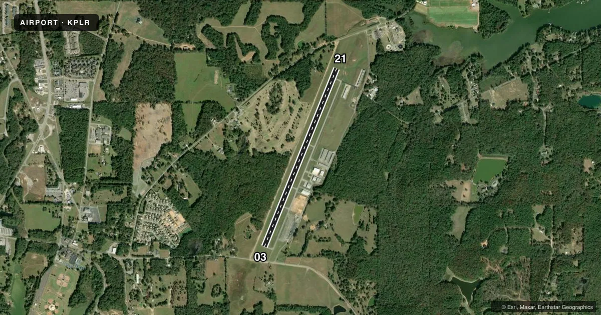
Runways & pattern
Full pagePattern entry · RWY 03
LEFT TRAFFICRunway end performance
| End | TORA | TODA | ASDA | LDA | VGSI | Approach lights | Obstruction |
|---|---|---|---|---|---|---|---|
| 03 | — | — | — | — | PAPI 4-box left(3°) | — | 100', tree, 1038' from thr, 385' R of cntrln, slope 8 |
| 21 | — | — | — | — | PAPI 4-box left(3°) | — | 29', tree, 385' from thr, 196' R of cntrln, slope 6 |
Declared distances in feet. TORA = takeoff run available, TODA = takeoff distance, ASDA = accelerate-stop, LDA = landing distance.
Airport sketch
Runways drawn to scale from FAA survey coordinates, rendered over satellite imagery. Not for navigation.
Approaches & charts
Services on the field
Fuel grades, oxygen, maintenance, ramp storage and lighting — as declared to the FAA by the airport operator.
Fuel & services
- Fuel
- 100LLA+
- Oxygen (bottled)
- Not available
- Oxygen (bulk)
- Not available
- Airframe repair
- Major
- Power plant repair
- Major
- Other services
- AVNCS,INSTR,RNTL
Ramp & ground
- Transient storage
- Tie-down
- Landing fee
- No fee published
- Customs
- Not available
- Lighting schedule
- SEE RMK
- Beacon schedule
- SS-SR
- Beacon
- White / Green (civil land)(WG)
- Wind indicator
- Lighted
- Segmented circle
- No
Fuel & FBOs
Cheapest 100LL and Jet A on the field and nearby. Always confirm with the FBO before taxi.
Airport notes
Surface conditions, obstructions, local procedures, lighting outages and other notes published with each FAA cycle.
General notes
- GCO AVBL ON FREQ 121.725 THRU BIRMINGHAM (BMH) CLEARANCE DELIVERY.
- FOR CD IF UNA VIA GCO CTC BIRMINGHAM APCH AT 205-769-3890/3891.
Lighting notes
- ACTVT PAPI RWY 03 & 21; MIRL RWY 03/21 - CTAF.
Fuel notes
- 100LL100LL FUEL AVBL 24/7 WITH CC.
- A+FOR JET FUEL AFT HRS CALL 205-229-6668.
Approach & departure obstructions
- 03RWY 03 APCH RATIO 24:1 TO DSPLCD THLD.
Other notes
- THIS AIRPORT HAS BEEN SURVEYED BY THE NATIONAL GEODETIC SURVEY.
- OWNERCONTACT PERSON: ERSKINE FUNDERBURG; CHAIRMAN ST. CLAIR COUNTY ARPT AUTHORITY.
VFR map & nearby airports
VFR sectional. Tap any ICAO chip to open that airport.
Key facts · KPLR
Answer card- ICAO
- KPLR
- Name
- ST CLAIR COUNTY
- Location
- PELL CITY, ALABAMA
- Elevation
- 484.7 ft MSL
- Traffic pattern altitude
- 1,484.7 ft MSL (1,000 AGL)
- Control tower
- Non-towered (use CTAF)
- Total runways
- 1
- Longest runway
- 03/21 · 5,001 ft
- Published ILS approaches
- 0
- Published frequencies
- 5
- Magnetic variation
- 4°
- Current flight rules
- LIFR
- Current wind
- 000° at 0 kt
- Favored runway now
- –
St Clair County Airport sits in Pell City, Alabama. The field elevation is 484.7 ft MSL. It has one asphalt runway, 03/21, at 5,001 ft. There is no control tower. Traffic uses CTAF 123.05, with ground control handled on 121.725 through Birmingham clearance delivery. The published pattern altitude is not listed, so use the standard 1,000 ft AGL for light piston traffic unless the current Chart Supplement says otherwise.
There are no ILS approaches published here. Runway 03 has a published obstacle note on the approach side, so pay attention to the displaced threshold and the runway environment on arrival. PAPI is available for runways 03 and 21. Medium intensity runway lights are on both ends and are CTAF controlled.
The on-field FBO is St. Clair County Airport. It carries 100LL and Jet A Prist. 100LL is available 24 hours a day with credit card. For jet fuel after hours, call the number in the Chart Supplement or the FBO directly before you go. This is a non-towered field with Birmingham approach supporting clearances and approach services, so brief your frequency plan before descent. If you need current clearance delivery details or any local operating note, check the current FAA Chart Supplement or call the airport operator directly.