METAR & TAF KEET
Current METAR
Observed 02:53Z
KEET 270253Z AUTO 00000KT 6SM BR CLR 27/26 A2996 RMK AO2 SLP137 T02720256 53010 $
- Wind
- 000° @ 0 kt
- Visibility
- 6 SM
- Temp / Dew
- 27°C / 26°C
- Altimeter
- 29.96 inHg
- Clouds
- CLR
- Density alt
- 2,117 ft
- Ceiling
- Unlimited
- Rules
- VFR
Airport info & contacts
Manager on record, flight service, ARTCC, attendance schedule and pattern altitude — published by the FAA and refreshed every 28 days.
Location
- From city
- 4 NM SE
- VFR sectional
- ATLANTA
- ARTCC
- ZTL · ATLANTA
- NOTAM facility
- EET (NOTAM-D)
Airport manager
- Name
- TERRY FRANKLIN
- Phone
- 205 670 6359
- Address
- 265 WEATHER VANE ROAD, CALERA AL 35040
Flight service · Hours
- FSS ANB
- ANNISTON1-800-WX-BRIEF
- Attendance
- 0700-1900
Frequencies
Tap any row to copy the frequency to your clipboard.
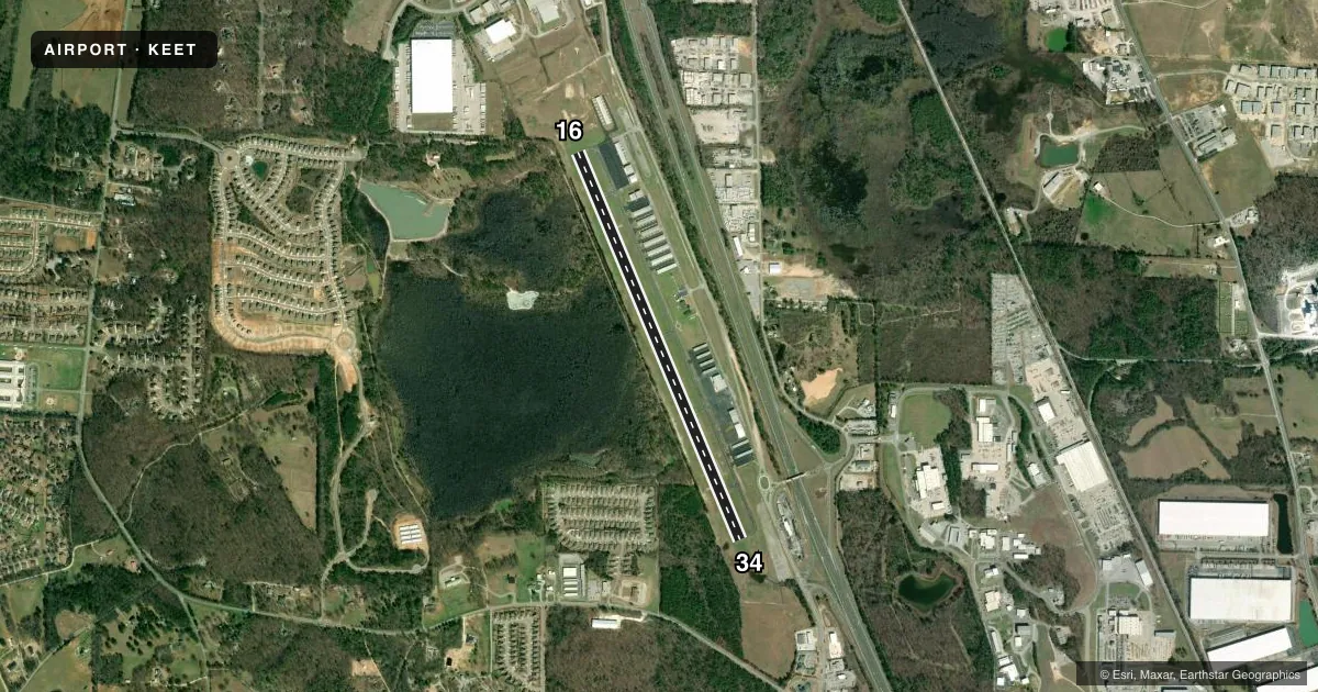
Runways & pattern
Full pagePattern entry · RWY 16
LEFT TRAFFICRunway end performance
| End | TORA | TODA | ASDA | LDA | VGSI | Approach lights | Obstruction |
|---|---|---|---|---|---|---|---|
| 16 | — | — | — | — | PAPI 4-box left(3.5°) | — | 109', tree, 1823' from thr, 510' R of cntrln, slope 14 |
| 34 | — | — | — | — | PAPI 4-box left(4°) | — | 64', tree, 1505' from thr, 97' R of cntrln, slope 20 |
Declared distances in feet. TORA = takeoff run available, TODA = takeoff distance, ASDA = accelerate-stop, LDA = landing distance.
Airport sketch
Runways drawn to scale from FAA survey coordinates, rendered over satellite imagery. Not for navigation.
Approaches & charts
Services on the field
Fuel grades, oxygen, maintenance, ramp storage and lighting — as declared to the FAA by the airport operator.
Fuel & services
- Fuel
- 100LLA+
- Oxygen (bottled)
- Not available
- Oxygen (bulk)
- Not available
- Airframe repair
- Major
- Power plant repair
- Major
- Other services
- INSTR,RNTL,SALES
Ramp & ground
- Transient storage
- Tie-down
- Landing fee
- No fee published
- Customs
- Not available
- Lighting schedule
- SEE RMK
- Beacon schedule
- SS-SR
- Beacon
- White / Green (civil land)(WG)
- Wind indicator
- Lighted
- Segmented circle
- Yes
Fuel & FBOs
Cheapest 100LL and Jet A on the field and nearby. Always confirm with the FBO before taxi.
Airport notes
Surface conditions, obstructions, local procedures, lighting outages and other notes published with each FAA cycle.
General notes
- NOISE ABATEMENT AREA NW OF ARPT.
- BALLOON OPS, HANG GLIDING, PAJA, AND MOTORIZED PARACHUTE OPS PROHIBITED.
- GCO AVBL ON FREQ 121.725 THRU BHM CLEARANCE DELIVERY.
- FOR CD IF UNA VIA GCO CTC BIRMINGHAM APCH AT 205-769-3890.
- 24/7 EMERG CTC # 205-438-5173
Lighting notes
- ACTVT REIL RWY 16 & 34; PAPI RWY 16 & 34; MIRL RWY 16/34 - CTAF
Fuel notes
- 100LL100LL AVBL 24/7 WITH CC.
Other notes
- OWNERCHAD SCROGGINS, COUNTY MANAGER
VFR map & nearby airports
VFR sectional. Tap any ICAO chip to open that airport.
Key facts · KEET
Answer card- ICAO
- KEET
- Name
- SHELBY COUNTY
- Location
- ALABASTER, ALABAMA
- Elevation
- 585.6 ft MSL
- Traffic pattern altitude
- 1,585.6 ft MSL (1,000 AGL)
- Control tower
- Non-towered (use CTAF)
- Total runways
- 1
- Longest runway
- 16/34 · 5,000 ft
- Published ILS approaches
- 0
- Published frequencies
- 5
- Magnetic variation
- 3°
- Current flight rules
- VFR
- Current wind
- 000° at 0 kt
- Favored runway now
- –
Shelby County Airport sits in Alabaster, Alabama. Field elevation is 585.6 ft MSL. The airport has one runway. Runway 16/34 is 5,000 ft long with asphalt pavement. There is no control tower. Traffic pattern altitude is not published. Use the standard 1,000 ft AGL pattern for light piston aircraft unless the current Chart Supplement says otherwise.
No ILS approaches are published here. That makes this a basic VFR and non-precision planning field. Runway end identifier lights are available on 16 and 34. PAPI is available on both ends. Medium intensity runway lights are on the common traffic advisory frequency. 100LL is available 24 hours a day with a credit card. The on-field FBO is Shelby County Airport. It carries 100LL and Jet A Prist.
For radio work, Birmingham handles clearance delivery and approach or departure control. A ground communications outlet is available on 121.725 through Birmingham clearance delivery. There is also a published noise abatement area northwest of the airport. Balloon operations, hang gliding, powered parachute and motorized parachute operations are prohibited. If you are new to the field, brief the lighting setup and the non-towered pattern before arrival. Check the current Chart Supplement for any updates before you go.