METAR & TAF KSCD
Current METAR
Observed 05:15Z
KSCD 270515Z AUTO 00000KT 7SM CLR 26/26 A2998 RMK AO2 T02560256 $
- Wind
- 000° @ 0 kt
- Visibility
- 7 SM
- Temp / Dew
- 26°C / 26°C
- Altimeter
- 29.98 inHg
- Clouds
- CLR
- Density alt
- 1,951 ft
- Ceiling
- Unlimited
- Rules
- VFR
Airport info & contacts
Manager on record, flight service, ARTCC, attendance schedule and pattern altitude — published by the FAA and refreshed every 28 days.
Location
- From city
- 3 NM W
- VFR sectional
- ATLANTA
- ARTCC
- ZTL · ATLANTA
- NOTAM facility
- ANB (NOTAM-D)
Airport manager
- Name
- WADE PRUITT
- Phone
- 256-245-3246
- Address
- 195 AIRPORT RD., SYLACAUGA AL 35151
Flight service · Hours
- FSS ANB
- ANNISTON1-800-WX-BRIEF
- Attendance
- MON-FRI · 0800-1600
Frequencies
Tap any row to copy the frequency to your clipboard.
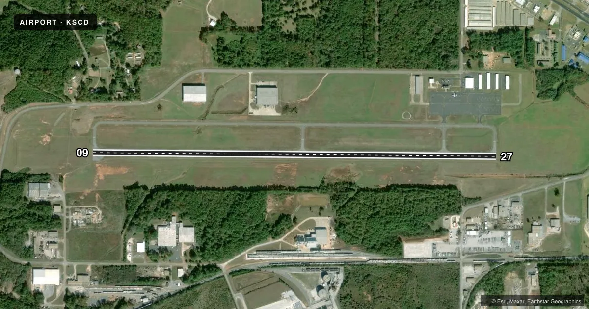
Runways & pattern
Full pagePattern entry · RWY 09
LEFT TRAFFICRunway end performance
| End | TORA | TODA | ASDA | LDA | VGSI | Approach lights | Obstruction |
|---|---|---|---|---|---|---|---|
| 09 | — | — | — | — | PAPI 2-box left(3°) | — | 125', tree, 2141' from thr, 182' R of cntrln, slope 15 |
| 27 | — | — | — | — | PAPI 2-box left(3°) | — | — |
Declared distances in feet. TORA = takeoff run available, TODA = takeoff distance, ASDA = accelerate-stop, LDA = landing distance.
Airport sketch
Runways drawn to scale from FAA survey coordinates, rendered over satellite imagery. Not for navigation.
Approaches & charts
Services on the field
Fuel grades, oxygen, maintenance, ramp storage and lighting — as declared to the FAA by the airport operator.
Fuel & services
- Fuel
- 100LLA+
- Oxygen (bottled)
- Not available
- Airframe repair
- Major
- Power plant repair
- Major
- Other services
- AMB,GLD,INSTR,TOW
Ramp & ground
- Transient storage
- Tie-down
- Landing fee
- No fee published
- Customs
- Not available
- Lighting schedule
- SEE RMK
- Beacon schedule
- SS-SR
- Beacon
- White / Green (civil land)(WG)
- Wind indicator
- Lighted
- Segmented circle
- Yes
Fuel & FBOs
Cheapest 100LL and Jet A on the field and nearby. Always confirm with the FBO before taxi.
Airport notes
Surface conditions, obstructions, local procedures, lighting outages and other notes published with each FAA cycle.
General notes
- DEER ON & INVOF ARPT.
- GLDR TOWING OPS 3 NM RADIUS BLW 6000 FT 0900-2200 WKENDS.
- FOR CD CTC BIRMINGHAM APCH AT 205-769-3890.
Lighting notes
- ACTVT REIL RWY 09 & 27; PAPI RWY 09 & 27: MIRL RWY 09/27 - CTAF.
Fuel notes
- 100LLFUEL AVBL 24/7 WITH CC.
Approach & departure obstructions
- 09OBSCURED/FADED
- 27OBSCURED/FADED
Other notes
- GLDGLDR CLUB ON FLD.
VFR map & nearby airports
VFR sectional. Tap any ICAO chip to open that airport.
Key facts · KSCD
Answer card- ICAO
- KSCD
- Name
- MERKEL FLD SYLACAUGA MUNI
- Location
- SYLACAUGA, ALABAMA
- Elevation
- 568.9 ft MSL
- Traffic pattern altitude
- 1,568.9 ft MSL (1,000 AGL)
- Control tower
- Non-towered (use CTAF)
- Total runways
- 1
- Longest runway
- 09/27 · 5,390 ft
- Published ILS approaches
- 0
- Published frequencies
- 4
- Magnetic variation
- 3°
- Current flight rules
- VFR
- Current wind
- 000° at 0 kt
- Favored runway now
- –
Merkel Fld Sylacauga Muni is in Sylacauga, Alabama. The field elevation is 568.9 ft MSL. It has one runway, 09/27, which is 5,390 ft long. There is no control tower. CTAF and UNICOM are both 122.8. The published traffic pattern altitude is not listed, so use the standard 1,000 ft AGL pattern unless the current Chart Supplement says otherwise.
No ILS approaches are published here. Runway 09 and 27 have medium intensity lighting, PAPI and runway end identifier lights. The runway markings on both ends are reported as faded and obscured, so plan for a careful visual check on arrival. Deer are reported on and near the airport. That matters here, especially at dawn and dusk.
Sylacauga Airport is the on-field FBO. It carries 100LL and Jet A. 100LL is available 24 hours a day with a credit card. There is also a glider club on the field. Glider towing happens within 3 NM below 6,000 ft from 0900 to 2200 on weekends. Expect extra traffic in that window. For clearance delivery, Birmingham Approach handles it by phone. The airport sits in a non-towered environment, so listen carefully on CTAF and keep your scan tight.