METAR & TAF KASN
Current METAR
Observed 03:36Z
KASN 270336Z AUTO 18001KT 7SM BR CLR 27/27 A2993 RMK AO2
- Wind
- 180° @ 1 kt
- Visibility
- 7 SM
- Temp / Dew
- 27°C / 27°C
- Altimeter
- 29.93 inHg
- Clouds
- CLR
- Density alt
- 2,083 ft
- Ceiling
- Unlimited
- Rules
- VFR
Airport info & contacts
Manager on record, flight service, ARTCC, attendance schedule and pattern altitude — published by the FAA and refreshed every 28 days.
Location
- From city
- 8 NM NE
- VFR sectional
- ATLANTA
- ARTCC
- ZTL · ATLANTA
- NOTAM facility
- ANB (NOTAM-D)
Airport manager
- Name
- JIM BROCK
- Phone
- 256-761-4815
- Address
- 566 AIRPORT DRIVE, LINCOLN AL 35096
Flight service · Hours
- FSS ANB
- ANNISTON1-800-WX-BRIEF
- Attendance
- MON-FRI · 0800-1600
Frequencies
Tap any row to copy the frequency to your clipboard.
Runways & pattern
Full pagePattern entry · RWY 22
LEFT TRAFFICRunway end performance
| End | TORA | TODA | ASDA | LDA | VGSI | Approach lights | Obstruction |
|---|---|---|---|---|---|---|---|
| 04 | — | — | — | — | PAPI 4-box left(3°) | — | 63', trees, 1725' from thr, 205' R of cntrln, slope 24 |
| 22 | — | — | — | — | PAPI 4-box left(3°) | — | 71', trees, 1482' from thr, 367' R of cntrln, slope 18 |
Declared distances in feet. TORA = takeoff run available, TODA = takeoff distance, ASDA = accelerate-stop, LDA = landing distance.
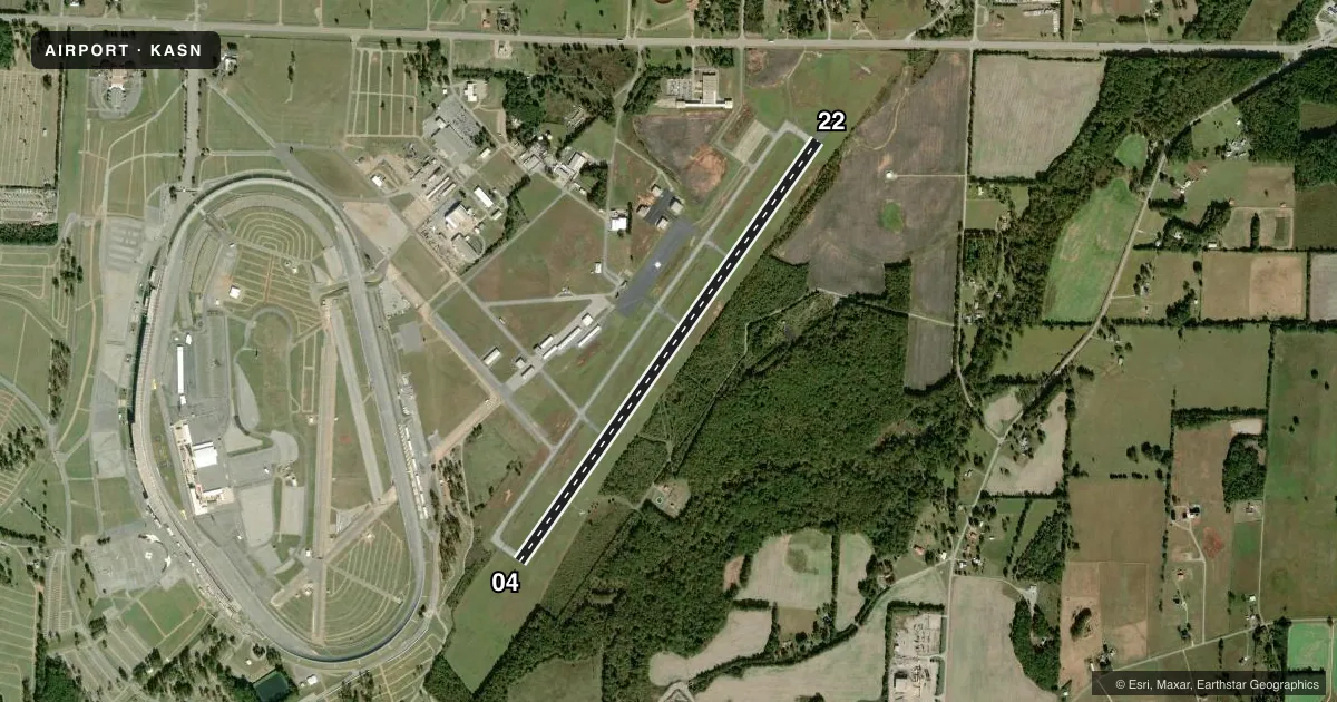
Airport sketch
Runways drawn to scale from FAA survey coordinates, rendered over satellite imagery. Not for navigation.
Approaches & charts
ILS · 1
Services on the field
Fuel grades, oxygen, maintenance, ramp storage and lighting — as declared to the FAA by the airport operator.
Fuel & services
- Fuel
- 100LLAA+
- Oxygen (bottled)
- Not available
- Oxygen (bulk)
- Not available
- Airframe repair
- Minor
- Power plant repair
- Minor
Ramp & ground
- Transient storage
- Tie-down
- Landing fee
- No fee published
- Customs
- Not available
- Lighting schedule
- SEE RMK
- Beacon schedule
- SS-SR
- Beacon
- White / Green (civil land)(WG)
- Wind indicator
- Lighted
- Segmented circle
- Yes
Fuel & FBOs
Cheapest 100LL and Jet A on the field and nearby. Always confirm with the FBO before taxi.
Airport notes
Surface conditions, obstructions, local procedures, lighting outages and other notes published with each FAA cycle.
General notes
- TMPRY ATCT BY NOTAM FOR SPECIAL EVENTS.
- DEER ON & INVOF ARPT.
- AFT HR SVC CALL 205-369-4941.
- FOR CD CTC BIRMINGHAM APCH AT 205-769-3890.
Lighting notes
- ACTVT REIL RWY 04; HIRL RWY 04/22; TWY LGTS - CTAF. PAPI RWY 04 & 22 OPR CONSLY.
Approach & departure obstructions
- 04MARKINGS POOR DUE TO FADING.
- 22MARKINGS POOR DUE TO FADING.
Other notes
- CLSD TO ACFT OPS WITH MORE THAN 30 PSGR SEATS EXCP PPR CALL AMGR (256) 761-4815.
- 1FBO ATTENDED MON-FRI 0800-1600.
VFR map & nearby airports
VFR sectional. Tap any ICAO chip to open that airport.
Key facts · KASN
Answer card- ICAO
- KASN
- Name
- TALLADEGA MUNI
- Location
- TALLADEGA, ALABAMA
- Elevation
- 528.8 ft MSL
- Traffic pattern altitude
- 1,528.8 ft MSL (1,000 AGL)
- Control tower
- Non-towered (use CTAF)
- Total runways
- 1
- Longest runway
- 04/22 · 6,032 ft
- Published ILS approaches
- 1
- Published frequencies
- 4
- Magnetic variation
- 3°
- Current flight rules
- VFR
- Current wind
- 180° at 1 kt
- Favored runway now
- RWY 22
Talladega Muni is in Talladega, Alabama. The field elevation is 528.8 ft MSL. It has one runway. Runway 04/22 is 6,032 ft asphalt, so it gives light and medium GA traffic a solid paved strip to work with.
There is no control tower in normal daily operation. A temporary tower can be put in place by NOTAM for special events. The airport has one ILS approach to runway 04. Pattern altitude is not published. Use the standard 1,000 ft AGL for light piston operations unless the current Chart Supplement says otherwise. That puts the pattern at about 1,529 ft MSL.
Talladega Municipal Airport is the on-field FBO. It carries 100LL, Jet A and Jet A Prist. The FBO is attended Monday through Friday from 0800 to 1600. After-hours service is available by phone. Runway 04 and 22 markings are reported as poor due to fading. Runway 04 has REILs. High intensity runway lights are installed on both runway ends. PAPI is available on 04 and 22. Taxiway lights are controlled by CTAF.
For first-time arrivals, watch for deer on and near the airport. The field is also closed to aircraft operations with more than 30 passenger seats except by prior permission. Call the airport manager if you need that approval. For clearance delivery, contact Birmingham Approach. Check the current Chart Supplement for any current operational notes before you go.