METAR & TAF 20A
20A does not publish a METAR.
Showing the nearest reporting station: KGAD (NORTHEAST ALABAMA RGNL) · 14.4 NM away. Conditions at 20A may differ.
METAR · KGAD
Observed 18:56Z
KGAD 141856Z AUTO 06005KT FEW019 28/24 A3010 RMK AO2 LTG DSNT S SLPNO T02780239 PWINO $
- Wind
- 060° @ 5 kt
- Visibility
- —
- Temp / Dew
- 28°C / 24°C
- Altimeter
- 30.10 inHg
- Clouds
- FEW
- Density alt
- 2,732 ft
- Ceiling
- Unlimited
- Rules
- VFR
Airport info & contacts
Manager on record, flight service, ARTCC, attendance schedule and pattern altitude — published by the FAA and refreshed every 28 days.
Location
- From city
- 5 NM NE
- VFR sectional
- ATLANTA
- ARTCC
- ZTL · ATLANTA
- NOTAM facility
- ANB (NOTAM-D)
Airport manager
- Name
- BRANDON HORTON
- Phone
- 205-960-3553
- Address
- 202 3RD AVE EAST, ONEONTA AL 35121
Flight service · Hours
- FSS ANB
- ANNISTON1-800-WX-BRIEF
- Attendance
- Unattended
Frequencies
Tap any row to copy the frequency to your clipboard.
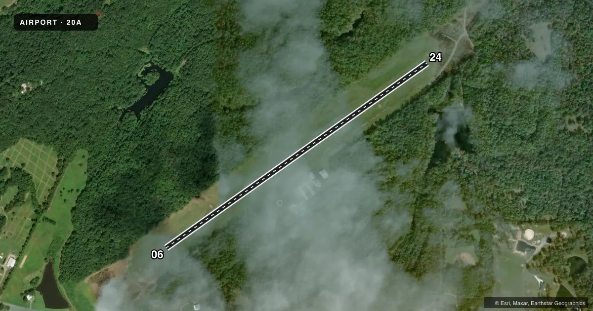
Runways & pattern
Full pagePattern entry · RWY 06
LEFT TRAFFICRunway end performance
| End | TORA | TODA | ASDA | LDA | VGSI | Approach lights | Obstruction |
|---|---|---|---|---|---|---|---|
| 06 | 4,098' | 4,098' | 4,098' | 4,098' | PAPI 2-box left(4°) | — | — |
| 24 | 4,203' | 4,203' | 4,203' | 4,098' | PAPI 2-box left(3°) | — | — |
Declared distances in feet. TORA = takeoff run available, TODA = takeoff distance, ASDA = accelerate-stop, LDA = landing distance.
Airport sketch
Runways drawn to scale from FAA survey coordinates, rendered over satellite imagery. Not for navigation.
Approaches & charts
Services on the field
Fuel grades, oxygen, maintenance, ramp storage and lighting — as declared to the FAA by the airport operator.
Fuel & services
- Fuel
- Not available
- Oxygen (bottled)
- Not available
- Oxygen (bulk)
- Not available
- Airframe repair
- Not available
- Power plant repair
- Not available
- Other services
- INSTR
Ramp & ground
- Transient storage
- Tie-down
- Landing fee
- No fee published
- Customs
- Not available
- Lighting schedule
- SEE RMK
- Beacon schedule
- SS-SR
- Beacon
- White / Green (civil land)(WG)
- Wind indicator
- Lighted
- Segmented circle
- Yes
Fuel & FBOs
Cheapest 100LL and Jet A on the field and nearby. Always confirm with the FBO before taxi.
Airport notes
Surface conditions, obstructions, local procedures, lighting outages and other notes published with each FAA cycle.
General notes
- DEER ON & INVOF ARPT.
- FOR CD CTC BIRMINGHAM APCH AT (205) 769-3890.
Lighting notes
- ACTVT PAPI RWY 6; MIRL RWY 06/24 - CTAF.
Approach & departure obstructions
- 06RWY 24 APCH SLP 12:1 TO DSPLCD THR.
VFR map & nearby airports
VFR sectional. Tap any ICAO chip to open that airport.
Key facts · 20A
Answer card- ICAO
- 20A
- Name
- ROBBINS FLD
- Location
- ONEONTA, ALABAMA
- Elevation
- 1,124.9 ft MSL
- Traffic pattern altitude
- 2,124.9 ft MSL (1,000 AGL)
- Control tower
- Non-towered (use CTAF)
- Total runways
- 1
- Longest runway
- 06/24 · 4,203 ft
- Published ILS approaches
- 0
- Published frequencies
- 4
- Magnetic variation
- 3°
- Current flight rules
- VFR
- Current wind
- 060° at 5 kt
- Favored runway now
- RWY 06
Robbins Fld is in Oneonta, Alabama. The field elevation is 1,124.9 ft MSL. It has one runway. Runway 06/24 is 4,203 ft of asphalt. There is no control tower. No ILS approaches are published here.
The pattern altitude is not published. Use 1,000 ft AGL for light piston operations unless the current Chart Supplement says otherwise. For this field, that puts pattern altitude at about 2,124.9 ft MSL. The airport uses CTAF 122.8. UNICOM is also 122.8. Birmingham Approach serves the field on 125.45 and 279.65. Clearance delivery is handled through Birmingham Approach at (205) 769-3890.
There are no on-field FBOs listed. Deer are reported on and near the airport. Use extra caution on taxi, takeoff and landing. Runway 24 has a published displaced-threshold slope note. Runway 6 has a PAPI. Medium intensity runway lights are available on both runways and are controlled by CTAF. Pilots should also note the airport sits at over 1,100 ft MSL. Performance will be a little different than at low-elevation fields.