METAR & TAF KPYP
KPYP does not publish a METAR.
Showing the nearest reporting station: KGAD (NORTHEAST ALABAMA RGNL) · 25.0 NM away. Conditions at KPYP may differ.
METAR · KGAD
Observed 18:56Z
KGAD 141856Z AUTO 06005KT FEW019 28/24 A3010 RMK AO2 LTG DSNT S SLPNO T02780239 PWINO $
- Wind
- 060° @ 5 kt
- Visibility
- —
- Temp / Dew
- 28°C / 24°C
- Altimeter
- 30.10 inHg
- Clouds
- FEW
- Density alt
- 2,074 ft
- Ceiling
- Unlimited
- Rules
- VFR
Airport info & contacts
Manager on record, flight service, ARTCC, attendance schedule and pattern altitude — published by the FAA and refreshed every 28 days.
Location
- From city
- 5 NM S
- VFR sectional
- ATLANTA
- ARTCC
- ZTL · ATLANTA
- NOTAM facility
- ANB (NOTAM-D)
Airport manager
- Name
- DONNIE FREE
- Phone
- 256-927-8009
- Address
- P.O. 466, 8850 ALABAMA HWY 9 S, CENTRE AL 35960
Flight service · Hours
- FSS ANB
- ANNISTON1-800-WX-BRIEF
- Attendance
- MON-FRI · 0800-1600
Frequencies
Tap any row to copy the frequency to your clipboard.
Runways & pattern
Full pagePattern entry · RWY 07
LEFT TRAFFICRunway end performance
| End | TORA | TODA | ASDA | LDA | VGSI | Approach lights | Obstruction |
|---|---|---|---|---|---|---|---|
| 07 | — | — | — | — | — | — | 75', trees, 2777' from thr, 43' R of cntrln, slope 34 |
Declared distances in feet. TORA = takeoff run available, TODA = takeoff distance, ASDA = accelerate-stop, LDA = landing distance.
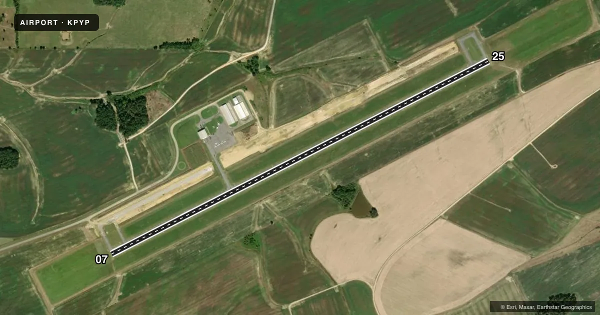
Airport sketch
Runways drawn to scale from FAA survey coordinates, rendered over satellite imagery. Not for navigation.
Approaches & charts
Services on the field
Fuel grades, oxygen, maintenance, ramp storage and lighting — as declared to the FAA by the airport operator.
Fuel & services
- Fuel
- 100LL
Ramp & ground
- Transient storage
- Tie-down
- Landing fee
- No fee published
- Lighting schedule
- SEE RMK
- Beacon schedule
- SS-SR
- Beacon
- White / Green (civil land)(WG)
- Wind indicator
- Lighted
- Segmented circle
- Yes
Fuel & FBOs
Cheapest 100LL and Jet A on the field and nearby. Always confirm with the FBO before taxi.
Airport notes
Surface conditions, obstructions, local procedures, lighting outages and other notes published with each FAA cycle.
General notes
- FOR CD CTC ATLANTA ARTCC AT 770-210-7692.
Lighting notes
- ACTVT MIRL RWY 07/25 - CTAF.
Runway surface & condition
- 07/25PCR VALUE: 90/F/D/X/T
Approach & departure obstructions
- 25RWY IDENTIFIER, CENTERLINE FADED
Other notes
- PRVDD CLEAR 20:1 APCHS AND THE RY CNTRLN HAVE LATERAL SEPN OF 60 FT FM ROADS AND OTR OBJECTS FOR ACFT WITH APCH SPDS LESS THAN 50 KTS AND 120 FT FOR ACFT WITH APCH SPDS OF 50 KTS OR GTR.
VFR map & nearby airports
VFR sectional. Tap any ICAO chip to open that airport.
Key facts · KPYP
Answer card- ICAO
- KPYP
- Name
- CENTRE PIEDMONT/CHEROKEE COUNTY RGNL
- Location
- CENTRE, ALABAMA
- Elevation
- 594.6 ft MSL
- Traffic pattern altitude
- 1,594.6 ft MSL (1,000 AGL)
- Control tower
- Non-towered (use CTAF)
- Total runways
- 1
- Longest runway
- 07/25 · 5,500 ft
- Published ILS approaches
- 0
- Published frequencies
- 1
- Magnetic variation
- 4°
- Current flight rules
- VFR
- Current wind
- 060° at 5 kt
- Favored runway now
- RWY 07
Centre Piedmont/Cherokee County Rgnl sits in Centre, Alabama. The field elevation is 594.6 ft MSL. It has one runway, 07/25 and the longest runway is 5,500 ft of asphalt. There is no control tower. CTAF is 122.9.
No ILS approaches are published here. The pattern altitude is not published, so use the standard 1,000 ft AGL for light piston operations unless the current Chart Supplement says otherwise. The runway lights on 07/25 are medium intensity and are activated by CTAF. For clearance delivery, contact Atlanta ARTCC at 770-210-7692.
There are no on-field FBOs listed in the facts. Call the airport operator or the field directly before arrival for current services. The published remarks also note a PCN of 90/F/D/X/T for runway 07/25. The runway centerline has lateral separation from roads and other objects. That matters if you are flying a slower aircraft or planning a tight visual approach. Check the current Chart Supplement for any noise or operational notes before you go.