METAR & TAF 7A5
7A5 does not publish a METAR.
Showing the nearest reporting station: KLGC (LAGRANGE/CALLAWAY) · 16.7 NM away. Conditions at 7A5 may differ.
METAR · KLGC
Observed 05:35Z
KLGC 270535Z AUTO 00000KT 3SM BR CLR 25/24 A2996 RMK AO2
- Wind
- 000° @ 0 kt
- Visibility
- 3 SM
- Temp / Dew
- 25°C / 24°C
- Altimeter
- 29.96 inHg
- Clouds
- CLR
- Density alt
- 2,275 ft
- Ceiling
- Unlimited
- Rules
- MVFR
Airport info & contacts
Manager on record, flight service, ARTCC, attendance schedule and pattern altitude — published by the FAA and refreshed every 28 days.
Location
- From city
- 2 NM S
- VFR sectional
- ATLANTA
- ARTCC
- ZTL · ATLANTA
- NOTAM facility
- ANB (NOTAM-D)
Airport manager
- Name
- KEITH RICHARDSON
- Phone
- 334-863-4129
- Address
- P.O. BOX 1270, ROANOKE AL 36274
Flight service · Hours
- FSS ANB
- ANNISTON1-800-WX-BRIEF
- Attendance
- Unattended
Frequencies
Tap any row to copy the frequency to your clipboard.
Runways & pattern
Full pagePattern entry · RWY 12
LEFT TRAFFICRunway end performance
| End | TORA | TODA | ASDA | LDA | VGSI | Approach lights | Obstruction |
|---|---|---|---|---|---|---|---|
| 12 | — | — | — | — | VASI 2-box left | — | 99', tree, 1754' from thr, 304' R of cntrln, slope 15 |
| 30 | — | — | — | — | VASI 2-box left | — | — |
Declared distances in feet. TORA = takeoff run available, TODA = takeoff distance, ASDA = accelerate-stop, LDA = landing distance.
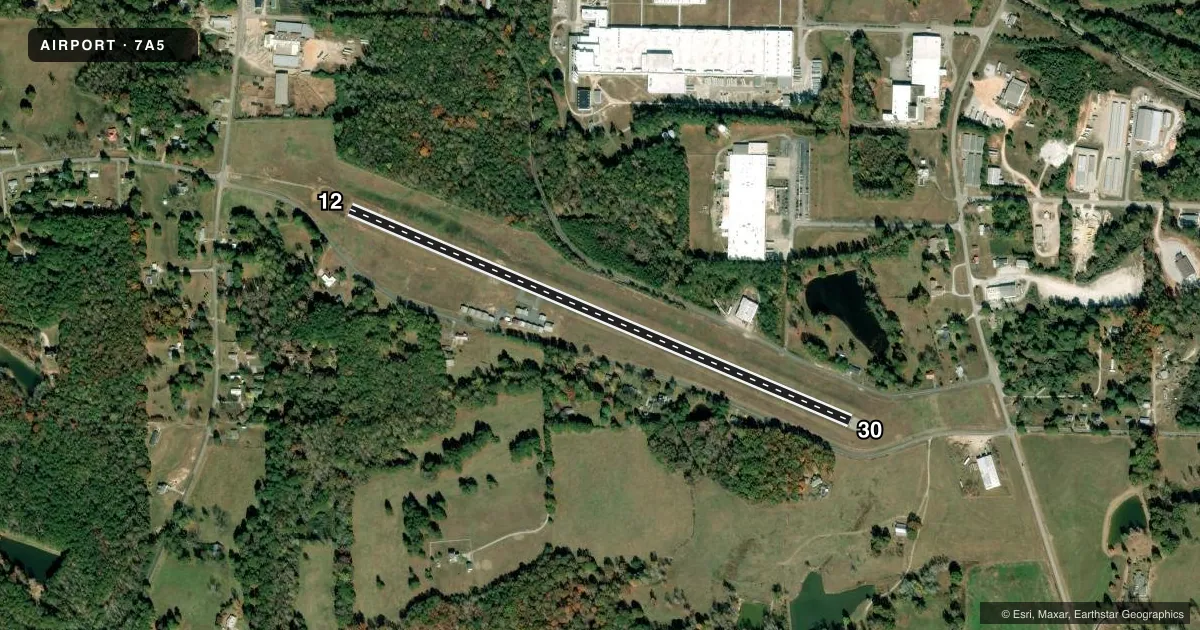
Airport sketch
Runways drawn to scale from FAA survey coordinates, rendered over satellite imagery. Not for navigation.
Approaches & charts
Services on the field
Fuel grades, oxygen, maintenance, ramp storage and lighting — as declared to the FAA by the airport operator.
Fuel & services
- Fuel
- Not available
- Oxygen (bottled)
- Not available
- Oxygen (bulk)
- Not available
- Airframe repair
- Not available
- Power plant repair
- Not available
Ramp & ground
- Transient storage
- Not published
- Landing fee
- No fee published
- Customs
- Not available
- Lighting schedule
- SS-SR
- Beacon schedule
- SS-SR
- Beacon
- White / Green (civil land)(WG)
- Wind indicator
- Lighted
- Segmented circle
- No
Fuel & FBOs
Cheapest 100LL and Jet A on the field and nearby. Always confirm with the FBO before taxi.
Airport notes
Surface conditions, obstructions, local procedures, lighting outages and other notes published with each FAA cycle.
General notes
- FOR ARPT EMERGS CALL (334) 863-2121 (POLICE).
- FOR CD CTC ATLANTA APCH AT 678-364-6132, WHEN APCH CLSD CTC ATLANTA ARTCC AT 770-210-7692.
Approach & departure obstructions
- 30RELCTD 146 FT FOR NGT OPNS.
- 12DSPLCD THR 389 FT FOR NGT OPNS. APCH RATIO 34:1 FOR NGT OPNS.
- 12OTS INDEFLY.
- 30OTS INDEFLY.
- 30APCH RATIO 41:1 TO DSPLCD THR.
- 12APCH RATIO 38:1 TO DSPLCD THR.
Other notes
- PRIOR TO ACT.
VFR map & nearby airports
VFR sectional. Tap any ICAO chip to open that airport.
Key facts · 7A5
Answer card- ICAO
- 7A5
- Name
- ROANOKE MUNI ENLOE
- Location
- ROANOKE, ALABAMA
- Elevation
- 907 ft MSL
- Traffic pattern altitude
- 1,907 ft MSL (1,000 AGL)
- Control tower
- Non-towered (use CTAF)
- Total runways
- 1
- Longest runway
- 12/30 · 3,561 ft
- Published ILS approaches
- 0
- Published frequencies
- 2
- Magnetic variation
- 1°
- Current flight rules
- MVFR
- Current wind
- 000° at 0 kt
- Favored runway now
- –
Roanoke Muni Enloe sits in Roanoke, Alabama at 907 ft MSL. It has one runway. The longest is 12/30 at 3,561 ft. This is an untowered field, so expect self-announce traffic on CTAF 122.9. Atlanta Approach handles 125.5 for approach and departure work.
No ILS approaches are published here. Pattern altitude is not published, so use the standard 1,000 ft AGL for light piston operations unless the current Chart Supplement says otherwise. The runway data also shows magnetic headings of 112.940547954038° for 12 and 292.940547954038° for 30. Magnetic variation is 1°.
There are no on-field FBOs listed, so plan ahead before you launch. Check with the airport operator or the FBO directly by phone for current services. The published remarks matter here. Runway 12 has a displaced threshold for night operations. Runway 30 also has a relocated threshold for night use. Both runways have visual glide slope indicators out of service indefinitely. The approach clearance slope ratios are also published for the displaced thresholds, so review them before you go.
For clearance delivery, contact Atlanta Approach at 678-364-6132. If Atlanta Approach is closed, contact Atlanta ARTCC at 770-210-7692. For airport emergencies, call Roanoke police at (334) 863-2121.