METAR & TAF 7A3
7A3 does not publish a METAR.
Showing the nearest reporting station: KLGC (LAGRANGE/CALLAWAY) · 14.2 NM away. Conditions at 7A3 may differ.
METAR · KLGC
Observed 08:55Z
KLGC 270855Z AUTO 00000KT 1 1/2SM BR VV007 23/23 A2992 RMK AO2 VIS 1/2V4
- Wind
- 000° @ 0 kt
- Visibility
- 0.5 SM
- Temp / Dew
- 23°C / 23°C
- Altimeter
- 29.92 inHg
- Clouds
- VV
- Density alt
- 1,742 ft
- Ceiling
- 700 ft AGL
- Rules
- LIFR
Airport info & contacts
Manager on record, flight service, ARTCC, attendance schedule and pattern altitude — published by the FAA and refreshed every 28 days.
Location
- From city
- 3 NM SW
- VFR sectional
- ATLANTA
- ARTCC
- ZTL · ATLANTA
- NOTAM facility
- ANB (NOTAM-D)
Airport manager
- Name
- CRAIG STAPLETON
- Phone
- 334-476-3184
- Address
- 4445 51ST AVE SW, PO BOX 290, LANETT AL 36863
Flight service · Hours
- FSS ANB
- ANNISTON1-800-WX-BRIEF
- Attendance
- ATTENDED · 0800-1700
Frequencies
Tap any row to copy the frequency to your clipboard.
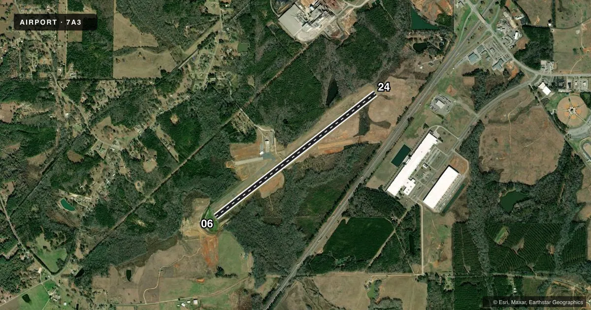
Runways & pattern
Full pagePattern entry · RWY 06
LEFT TRAFFICRunway end performance
| End | TORA | TODA | ASDA | LDA | VGSI | Approach lights | Obstruction |
|---|---|---|---|---|---|---|---|
| 06 | — | — | — | — | — | — | 60', fence, 1231' from thr, 292' R of cntrln, slope 17 |
| 24 | — | — | — | — | — | — | 10', tree, 293' from thr, 107' R of cntrln, slope 9 |
Declared distances in feet. TORA = takeoff run available, TODA = takeoff distance, ASDA = accelerate-stop, LDA = landing distance.
Airport sketch
Runways drawn to scale from FAA survey coordinates, rendered over satellite imagery. Not for navigation.
Approaches & charts
Services on the field
Fuel grades, oxygen, maintenance, ramp storage and lighting — as declared to the FAA by the airport operator.
Fuel & services
- Fuel
- 100LL
- Oxygen (bottled)
- Not available
- Oxygen (bulk)
- Not available
- Airframe repair
- Not available
- Power plant repair
- Not available
- Other services
- INSTR
Ramp & ground
- Transient storage
- Tie-down
- Landing fee
- No fee published
- Customs
- Not available
- Lighting schedule
- SEE RMK
- Beacon schedule
- SS-SR
- Beacon
- White / Green (civil land)(WG)
- Wind indicator
- Lighted
- Segmented circle
- Yes
Fuel & FBOs
Cheapest 100LL and Jet A on the field and nearby. Always confirm with the FBO before taxi.
Airport notes
Surface conditions, obstructions, local procedures, lighting outages and other notes published with each FAA cycle.
General notes
- DEER ON & INVOF ARPT.
- FOR CD CTC ATLANTA APCH AT 678-364-6132, WHEN APCH CLSD CTC ATLANTA ARTCC AT 770-210-7692.
Lighting notes
- ACTVT REIL RWY 06 & 24; MIRL RWY 06/24 - CTAF.
Fuel notes
- 100LLFUEL 24 HR CREDIT CARD SVC AVBL.
Other notes
- BUILT PRIOR TO FAA ACT.
- MANAGER334-476-3184
VFR map & nearby airports
VFR sectional. Tap any ICAO chip to open that airport.
Key facts · 7A3
Answer card- ICAO
- 7A3
- Name
- LANETT RGNL
- Location
- LANETT, ALABAMA
- Elevation
- 630.9 ft MSL
- Traffic pattern altitude
- 1,630.9 ft MSL (1,000 AGL)
- Control tower
- Non-towered (use CTAF)
- Total runways
- 1
- Longest runway
- 06/24 · 5,400 ft
- Published ILS approaches
- 0
- Published frequencies
- 5
- Magnetic variation
- 5°
- Current flight rules
- LIFR
- Current wind
- 000° at 0 kt
- Favored runway now
- –
Lanett Rgnl sits in Lanett, Alabama. Field elevation is 630.9 ft MSL. The airport has one runway. Runway 06/24 is 5,400 ft long with concrete pavement. There is no control tower. Traffic uses CTAF 122.8. Pattern altitude is not published, so use the standard 1,000 ft AGL for light piston operations unless the current Chart Supplement says otherwise.
No ILS approaches are published here. That matters if you are planning an IFR arrival in marginal weather. Check the current Chart Supplement and your approach plates before you go. The airport sits in a non-towered environment with Atlanta Approach handling the area frequencies listed in the facts. Clearance delivery is handled through Atlanta Approach when it is open. If approach is closed, contact Atlanta ARTCC.
Published remarks matter here. Deer are on and near the airport, so expect wildlife on taxi and runway surfaces. Fuel with 24-hour credit card service is available. There are no on-field FBOs listed in the facts, so confirm current services with the airport operator or the FBO directly by phone before arrival. Runway end identifier lights are on both ends of 06/24. Medium intensity runway lights are controlled by CTAF. That helps for night work, but you should still verify current lighting status before a late arrival.