METAR & TAF 06A
06A does not publish a METAR.
Showing the nearest reporting station: KAUO (AUBURN UNIVERSITY RGNL) · 15.5 NM away. Conditions at 06A may differ.
METAR · KAUO
Observed 19:56Z
KAUO 091956Z AUTO 28008KT 10SM VCTS FEW043 SCT090 SCT110 32/23 A3009 RMK AO2 LTG DSNT ALQDS TSE00B09E24B39 SLP175 T03170233 $
- Wind
- 280° @ 8 kt
- Visibility
- 10 SM
- Temp / Dew
- 32°C / 23°C
- Altimeter
- 30.09 inHg
- Clouds
- SCT
- Density alt
- 2,157 ft
- Ceiling
- Unlimited
- Rules
- VFR
Airport info & contacts
Manager on record, flight service, ARTCC, attendance schedule and pattern altitude — published by the FAA and refreshed every 28 days.
Location
- From city
- 3 NM N
- VFR sectional
- ATLANTA
- ARTCC
- ZTL · ATLANTA
- NOTAM facility
- ANB (NOTAM-D)
Airport manager
- Name
- NIKKI JORDAN
- Phone
- 334-724-0208
- Address
- 1729 GENERAL B.O. DAVIS JR DRIVE, TUSKEGEE AL 36083
Flight service · Hours
- FSS ANB
- ANNISTON1-800-WX-BRIEF
- Attendance
- 0700-1700
Frequencies
Tap any row to copy the frequency to your clipboard.
Runways & pattern
Full pagePattern entry · RWY 31
LEFT TRAFFICRunway end performance
| End | TORA | TODA | ASDA | LDA | VGSI | Approach lights | Obstruction |
|---|---|---|---|---|---|---|---|
| 13 | — | — | — | — | PAPI 2-box left(3°) | — | 18', trees, 274' from thr, 136' R of cntrln, slope 4 |
| 31 | — | — | — | — | PAPI 2-box left(3°) | — | 109', trees, 1265' from thr, 47' R of cntrln, slope 9 |
Declared distances in feet. TORA = takeoff run available, TODA = takeoff distance, ASDA = accelerate-stop, LDA = landing distance.
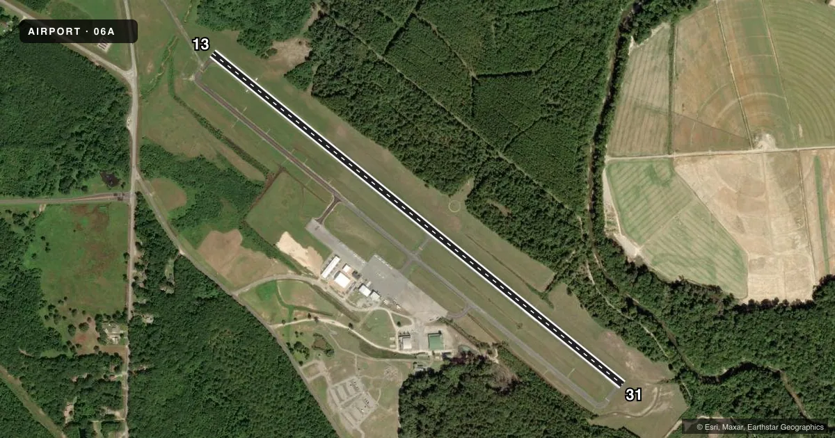
Airport sketch
Runways drawn to scale from FAA survey coordinates, rendered over satellite imagery. Not for navigation.
Approaches & charts
Services on the field
Fuel grades, oxygen, maintenance, ramp storage and lighting — as declared to the FAA by the airport operator.
Fuel & services
- Fuel
- 100LLA+
- Oxygen (bottled)
- Not available
- Oxygen (bulk)
- Not available
- Airframe repair
- Not available
- Power plant repair
- Not available
- Other services
- INSTR,RNTL
Ramp & ground
- Transient storage
- Tie-down
- Hangar
- Landing fee
- No fee published
- Customs
- Not available
- Lighting schedule
- SEE RMK
- Beacon schedule
- SS-SR
- Beacon
- White / Green (civil land)(WG)
- Wind indicator
- Lighted
- Segmented circle
- Yes
Fuel & FBOs
Cheapest 100LL and Jet A on the field and nearby. Always confirm with the FBO before taxi.
Airport notes
Surface conditions, obstructions, local procedures, lighting outages and other notes published with each FAA cycle.
General notes
- PARL TWY LGTD FULL LEN.
- WILDLIFE ON & INVOF ARPT.
- FOR CD CTC ATLANTA APCH AT 678-364-6132, WHEN APCH CLSD CTC ATLANTA ARTCC AT 770-210-7692.
Lighting notes
- ACTVT MIRL RWY 13/31 - CTAF.
Approach & departure obstructions
- 13OTS
- 31OTS
Other notes
- 1AFT HRS 334-421-4266.
VFR map & nearby airports
VFR sectional. Tap any ICAO chip to open that airport.
Key facts · 06A
Answer card- ICAO
- 06A
- Name
- MOTON FLD MUNI
- Location
- TUSKEGEE, ALABAMA
- Elevation
- 264 ft MSL
- Traffic pattern altitude
- 1,264 ft MSL (1,000 AGL)
- Control tower
- Non-towered (use CTAF)
- Total runways
- 1
- Longest runway
- 13/31 · 5,005 ft
- Published ILS approaches
- 0
- Published frequencies
- 6
- Magnetic variation
- 3°
- Current flight rules
- VFR
- Current wind
- 280° at 8 kt
- Favored runway now
- RWY 31
Moton Fld Muni sits in Tuskegee, Alabama. Field elevation is 264 ft MSL. The airport has one runway. Runway 13/31 is 5,005 ft of asphalt, so it works for a lot of light piston traffic and some larger aircraft within performance limits. There is no control tower. CTAF and UNICOM are both 122.8. Approach and departure service is handled by Atlanta on the published frequencies.
No ILS approaches are published here. Pattern altitude is not published, so use standard 1,000 ft AGL for light piston operations unless the current Chart Supplement says otherwise. The on-field FBO is Moton Field Municipal Airport. It carries 100LL and Jet A. Call ahead at (334) 727-6485 for current services.
A few remarks matter here. The parallel taxiway is lighted for its full length. Medium intensity runway lights on 13/31 are activated by CTAF. Visual glide slope indicators are out of service on both runway ends. Wildlife is reported on and near the airport, so keep a sharp scan on taxi and final. For clearance delivery, contact Atlanta Approach. If approach is closed, contact Atlanta ARTCC. First-time visitors should also plan for non-towered ops and verify current procedures with the airport operator or the current FAA Chart Supplement before departure.