METAR & TAF KMGM
Current METAR
Observed 09:53Z
KMGM 270953Z AUTO 00000KT 6SM BR CLR 24/24 A2991 RMK AO2 SLP124 T02440239
- Wind
- 000° @ 0 kt
- Visibility
- 6 SM
- Temp / Dew
- 24°C / 24°C
- Altimeter
- 29.91 inHg
- Clouds
- CLR
- Density alt
- 1,367 ft
- Ceiling
- Unlimited
- Rules
- VFR
Airport info & contacts
Manager on record, flight service, ARTCC, attendance schedule and pattern altitude — published by the FAA and refreshed every 28 days.
Location
- From city
- 6 NM SW
- VFR sectional
- ATLANTA
- Pattern altitude
- 1,200 ft AGL · 1,421 ft MSL
- ARTCC
- ZTL · ATLANTA
- NOTAM facility
- MGM (NOTAM-D)
Airport manager
- Name
- LOYD JENKINS
- Phone
- 334-281-5040
- Address
- 4445 SELMA HWY, MONTGOMERY AL 36108
Flight service · Hours
- FSS ANB
- ANNISTON1-800-WX-BRIEF
- Attendance
- ALL
Frequencies
Tap any row to copy the frequency to your clipboard.
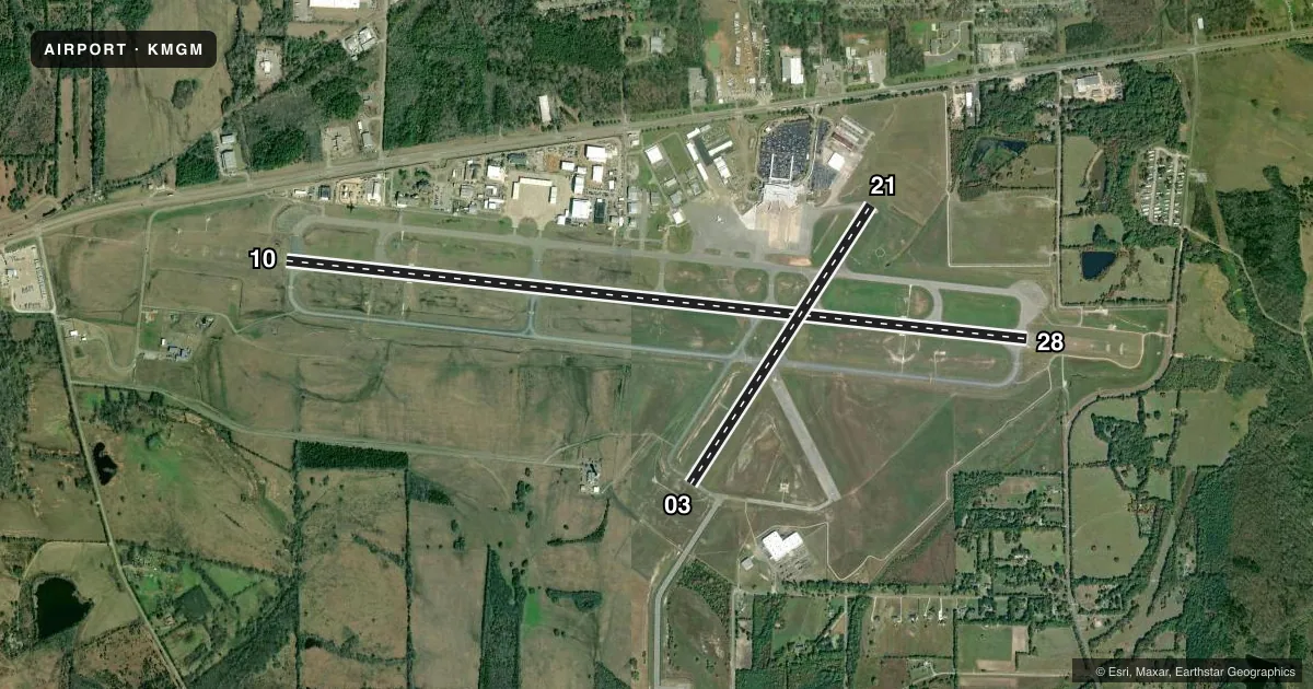
Runways & pattern
Full pagePattern entry · RWY 10
RIGHT TRAFFIC| Runway | Heading (°M) | Length | Surface | Traffic |
|---|---|---|---|---|
| 10/28 | 95° / 275° | 9,020 ft | ASPH | 10 R |
| 03/21 | 32° / 212° | 4,011 ft | ASPH | Standard L |
Runway end performance
| End | TORA | TODA | ASDA | LDA | VGSI | Approach lights | Obstruction |
|---|---|---|---|---|---|---|---|
| 10 | — | — | — | — | PAPI 4-box right(3°) | MALSR | 35', tree, 1990' from thr, 630' R of cntrln, slope 34 |
| 28 | — | — | — | — | PAPI 4-box left(3°) | MALSR | 65', tree, 2800' from thr, 600' R of cntrln, slope 40 |
| 03 | — | — | — | — | PAPI 4-box left(3°) | — | 22', fence, 700' from thr, 0' R of cntrln, slope 22 |
| 21 | — | — | — | — | PAPI 4-box left(3°) | — | 54', tree, 1300' from thr, 300' R of cntrln, slope 20 |
Declared distances in feet. TORA = takeoff run available, TODA = takeoff distance, ASDA = accelerate-stop, LDA = landing distance.
Airport sketch
Runways drawn to scale from FAA survey coordinates, rendered over satellite imagery. Not for navigation.
Approaches & charts
ILS · 2
Services on the field
Fuel grades, oxygen, maintenance, ramp storage and lighting — as declared to the FAA by the airport operator.
Fuel & services
- Fuel
- 100LLAA++
- Oxygen (bottled)
- Not available
- Oxygen (bulk)
- HIGH/LOW
- Airframe repair
- Major
- Power plant repair
- Major
- Other services
- AFRT,AVNCS,CARGO,CHTR,INSTR,RNTL,SALES
Ramp & ground
- Transient storage
- Tie-down
- Hangar
- Landing fee
- No fee published
- Customs
- Not available
- Lighting schedule
- SEE RMK
- Beacon schedule
- SS-SR
- Beacon
- White / Green (civil land)(WG)
- Wind indicator
- Lighted
- Segmented circle
- Yes
Fuel & FBOs
Cheapest 100LL and Jet A on the field and nearby. Always confirm with the FBO before taxi.
Airport notes
Surface conditions, obstructions, local procedures, lighting outages and other notes published with each FAA cycle.
General notes
- NO 180 DEG TURNS ON RWY 10/28 BY DC-9 OR LARGER ACFT.
- CAUTION: DO NOT MISTAKE MAXWELL AFB - 6 NM NORTH FOR MONGOMERY RGNL. NUMEROUS HEL AND LOW SPEED ACFT INVOF ARPT DURG DALGT HRS.
- ARNG: ANG RAMP CONST WIP. CTC AFLD MGMT FOR TAXI INSTR. TRANSPORT ACFT LTD TO MIN THRUST WHILE ON ANG RAMP. CONES BLOCKING THROAT OF ANG RAMP. CTC BASE OPS PRIOR TO ENTERING ANG RAMP FOR REMOVAL. INBD FOR ANG CTC BAMA OPS 15 MIN PRIOR LDG. ACFT PARKING EXTREMELY LMTD CTC BASE OPNS FOR PARKING INSTR. TSNT PARKING EXTREMELY LIMITED. PPR FOR USE OF ANG RAMP CTC ANG OPNS DSN358-9255/9256/C334-394-7255/7256. ANG BASE OPS FACILITY AVBL 1200-2230Z++.
- ACR & LRG MIL ACFT SHOULD NOT TAXI ON RWY 03/21.
- MILITARY: BIRD HAZARD. CTC BASE OPS ON 360.975 FOR CURRENT BIRD WATCH COND. BASH PHASE II BIRD ACT IS DURG APR AND FM 1 SEP TO 31 DEC.
- ARNG - F/W ACFT INBD TO ARNG RAMP CTC ARNG 10MIN PRIOR TO ETA AND UPON ENTY TWY D. L-3 (C-12)MAINT AVBL ON CALL, C334-280-4890 COMMUNICATIONS.
- MILITARY: ANG: ONGOING CONSTR ON RAMP. CTC BASE OPS FOR TAX/PRKG INSTRNS DSN 358-9255 OR C334-394-7255.
- ANG: RWY CC NOT RPT.
- FOR CD IF UNA TO CTC ON FSS FREQ, CTC DANNELLY APCH AT 334-284-4575, WHEN ATCT CLSD CTC ATLANTA ARTCC AT 770-210-7692.
- MILITARY: FLUID: LHNIT.
- MILITARY: OIL: JOAP.
- ANG RAMP - REDUCED WINGTIP CLEARANCE FOR PARKING SPOTS 11-16 WHEN F-35 LIGHTNING PROTECTION SYSTEMS IN USE.
- RSTD - TWY E 35' WIDE, MIL ACFT RSTD FM USE.
Lighting notes
- WHEN ATCT CLSD HIRL RWY 10/28 PRESET MED INTST, MIRL RWY 03/21 PRESET LOW INTST. PAPI RWYS 03, 21, 10, & 28 OPR CONSLY. ACTVT MALSR RWYS 10 & 28; REIL RWY 03 - CTAF.
Fuel notes
- ASERVICE-FUEL: ( A++100 (MIL)).
Runway surface & condition
- 10/28DC-10-10 320; DC-10-30 & 40 400; L1011 350; B747 500.
- 03/21PCR VALUE: 150/F/A/X/T
- 10/28PCR VALUE: 600/F/A/X/T
- 03/21RWY 03/21 NOT AVBL FOR PART 121/PART 380 OPS WITH SKED PAX CARRYING OPS MORE THAN 9 PAX SEATS AND NON-SKED PAX CARRYING OPS MORE THAN 30 PAX SEATS.
- 10/28MILITARY: RWY 10 AND RWY 28 BAK-12B(B) AVBL WITH 30 MIN PN 1200-0500Z++. 8 PT TIE-DOWNS ON BAK-12B(B). RAISED CABLE ON ATIS BCST.
Arresting gear
- 10_BAK-12BHOOK BAK-12B(B) (1500 FT).
- 28_BAK-12BHOOK BAK-12B(B) (1510 FT).
Other notes
- UP TO 2200 PSI.
- CLSD TO UNSKED ACR OPNS & LRG MIL ACFT REQUIRING PARKING, EXCP WITH 72 HRS PPR CTC AMGR 334-281-5040.
- ALABAMA ANG ONLY.
- TPA: 1200 FT AGL CONV ACFT, 1700 FT AGL JET ACFT.
VFR map & nearby airports
VFR sectional. Tap any ICAO chip to open that airport.
Key facts · KMGM
Answer card- ICAO
- KMGM
- Name
- MONTGOMERY RGNL (DANNELLY FLD)
- Location
- MONTGOMERY, ALABAMA
- Elevation
- 221.1 ft MSL
- Traffic pattern altitude
- 1,421.1 ft MSL (1,200 AGL)
- Control tower
- Towered · 0600-2300
- Total runways
- 2
- Longest runway
- 10/28 · 9,020 ft
- Published ILS approaches
- 2
- Published frequencies
- 23
- Magnetic variation
- 1°
- Current flight rules
- VFR
- Current wind
- 000° at 0 kt
- Favored runway now
- –
Montgomery Rgnl (Dannelly Fld) sits in Montgomery, Alabama. Field elevation is 232 ft MSL. The airport has 2 asphalt runways. The longest is 9,020 ft on 10/28. Tower service is available 0600-2300. Two ILS approaches are published for runway ends 10 and 28. Pattern altitude is 1,432 ft MSL, which is 1,200 ft AGL.
Montgomery Aviation is on the field. It carries 100LL, Jet A and Jet A Prist. If you need fuel or ramp details, call them at (334) 288-7334 before you go. The remarks also note military and Air National Guard activity on the field. Taxi instructions matter here. Aircraft parking is extremely limited. Transient parking is extremely limited. There is also a raised cable broadcast on ATIS for the military side of runway 10/28.
For a first-time arrival, plan for a busy controlled field with mixed civil and military use. Runway 10/28 is the main pavement for longer operations. Runway 03/21 is shorter at 4,011 ft. Check the current FAA Chart Supplement for any published noise or curfew restrictions before flying into the field. If you are using the Air National Guard ramp or need clearance help after tower hours, use the published contact numbers in the Chart Supplement or call the airport operator directly.