METAR & TAF KAUO
Current METAR
Observed 19:56Z
KAUO 091956Z AUTO 28008KT 10SM VCTS FEW043 SCT090 SCT110 32/23 A3009 RMK AO2 LTG DSNT ALQDS TSE00B09E24B39 SLP175 T03170233 $
- Wind
- 280° @ 8 kt
- Visibility
- 10 SM
- Temp / Dew
- 32°C / 23°C
- Altimeter
- 30.09 inHg
- Clouds
- SCT
- Density alt
- 2,792 ft
- Ceiling
- Unlimited
- Rules
- VFR
Airport info & contacts
Manager on record, flight service, ARTCC, attendance schedule and pattern altitude — published by the FAA and refreshed every 28 days.
Location
- From city
- 2 NM E
- VFR sectional
- ATLANTA
- ARTCC
- ZTL · ATLANTA
- NOTAM facility
- AUO (NOTAM-D)
Airport manager
- Name
- WILLIAM T. HUTTO
- Phone
- 334-844-4606
- Address
- 2150 BENT CREEK RD., AUBURN AL 36830
Flight service · Hours
- FSS ANB
- ANNISTON1-800-WX-BRIEF
- Attendance
- MON-FRI · 0700-2100
- SAT-SUN · 0800-1700
Frequencies
Tap any row to copy the frequency to your clipboard.
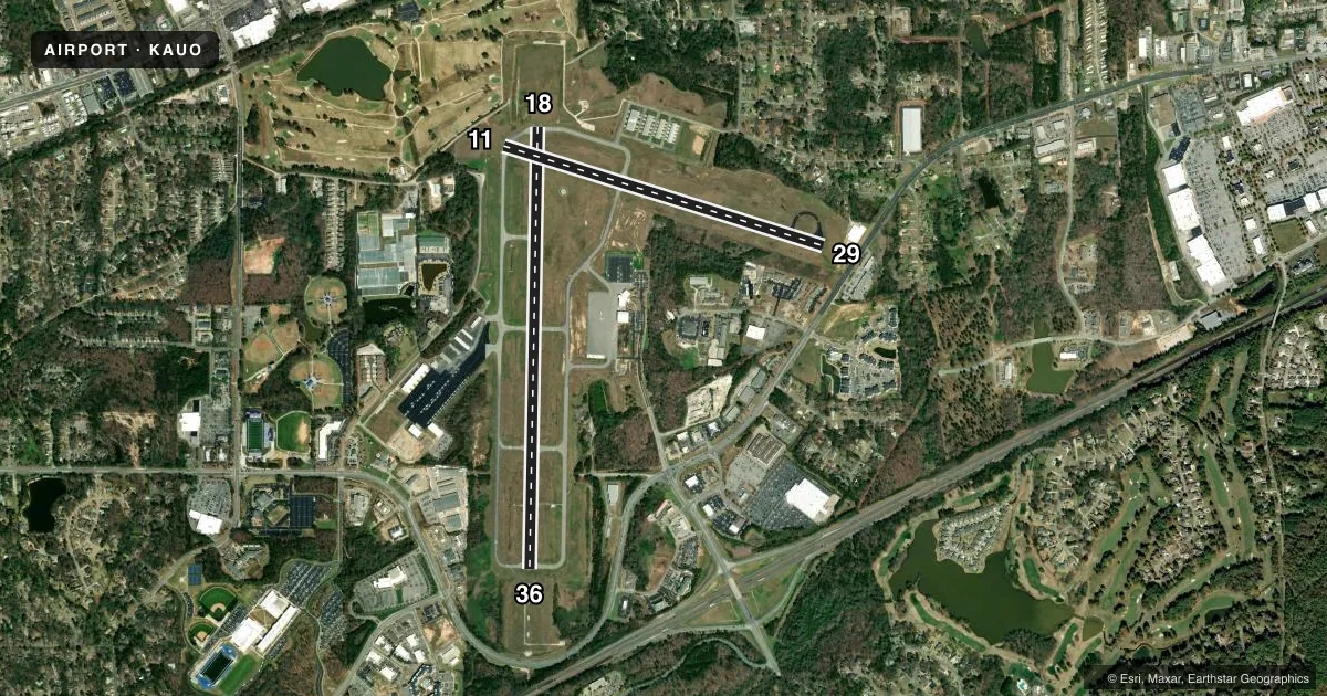
Runways & pattern
Full pagePattern entry · RWY 29
LEFT TRAFFIC| Runway | Heading (°M) | Length | Surface | Traffic |
|---|---|---|---|---|
| 18/36 | 177° / 357° | 5,264 ft | ASPH | Standard L |
| 11/29Favored | 103° / 283° | 4,000 ft | ASPH | Standard L |
Runway end performance
| End | TORA | TODA | ASDA | LDA | VGSI | Approach lights | Obstruction |
|---|---|---|---|---|---|---|---|
| 18 | — | — | — | — | — | — | 43', tree, 1204' from thr, 367' R of cntrln, slope 23 |
| 36 | — | — | — | — | PAPI 4-box left(3°) | MALSF | 8', tree, 212' from thr, 300' R of cntrln, slope 1 |
| 11 | — | — | — | — | — | — | 22', trees, 372' from thr, 192' R of cntrln, slope 7 |
| 29 | — | — | — | — | PAPI 4-box left(3°) | — | 63', tree, 954' from thr, 379' R of cntrln, slope 11 |
Declared distances in feet. TORA = takeoff run available, TODA = takeoff distance, ASDA = accelerate-stop, LDA = landing distance.
Airport sketch
Runways drawn to scale from FAA survey coordinates, rendered over satellite imagery. Not for navigation.
Approaches & charts
ILS · 1
Services on the field
Fuel grades, oxygen, maintenance, ramp storage and lighting — as declared to the FAA by the airport operator.
Fuel & services
- Fuel
- 100LLAA+
- Oxygen (bottled)
- Not available
- Oxygen (bulk)
- Not available
- Airframe repair
- Not available
- Power plant repair
- Not available
- Other services
- CHTR,INSTR,RNTL,SALES
Ramp & ground
- Transient storage
- Tie-down
- Landing fee
- No fee published
- Customs
- Not available
- Lighting schedule
- SEE RMK
- Beacon schedule
- SS-SR
- Beacon
- White / Green (civil land)(WG)
- Wind indicator
- Lighted
- Segmented circle
- Yes
Fuel & FBOs
Cheapest 100LL and Jet A on the field and nearby. Always confirm with the FBO before taxi.
Airport notes
Surface conditions, obstructions, local procedures, lighting outages and other notes published with each FAA cycle.
General notes
- JET START CPBLTY AVBL.
- HVY FLT STUDENT ACTVTY WI 35NM OF ARPT.
Lighting notes
- WHEN ATCT CLSD, ACTVT MALSF RWY 36; PAPI RWY 29 & 36; MIRL RWY 11/29; HIRL RWY 18/36 - CTAF.
Fuel notes
- 100LLSVC AFT HRS & HOL 334-501-3100.
Approach & departure obstructions
- 29APCH RATIO 26:1 FROM DSPLCD THLD.
Other notes
- ARPT PRECEDED ACT ANLYS NOT REQD.
VFR map & nearby airports
VFR sectional. Tap any ICAO chip to open that airport.
Key facts · KAUO
Answer card- ICAO
- KAUO
- Name
- AUBURN UNIVERSITY RGNL
- Location
- AUBURN, ALABAMA
- Elevation
- 776.8 ft MSL
- Traffic pattern altitude
- 1,776.8 ft MSL (1,000 AGL)
- Control tower
- Towered · 0700-2100 MON-FRI; 0800-1700 SAT & SUN
- Total runways
- 2
- Longest runway
- 18/36 · 5,264 ft
- Published ILS approaches
- 1
- Published frequencies
- 10
- Magnetic variation
- 4°
- Current flight rules
- VFR
- Current wind
- 280° at 8 kt
- Favored runway now
- RWY 29
Auburn University Rgnl sits in Auburn, Alabama. Field elevation is 776.8 ft MSL. The airport has two asphalt runways. The longest is 5,264 ft on runway 18/36. The tower is open 0700-2100 Monday through Friday. Weekend hours are 0800-1700.
Runway 36 has the published ILS approach. Pattern altitude is not published, so use 1,000 ft AGL for light piston operations unless ATC or the Chart Supplement says otherwise. Auburn University Aviation is on the field. It carries 100LL and Jet A. Call ahead if you need after-hours 100LL or holiday service. The field also has jet start capability.
This is a busy training airport. Heavy flight student activity occurs within 35 NM of the airport. Expect a lot of pattern work and radio traffic. Runway 29 has a published obstacle note tied to the displaced threshold. When the tower is closed, lighting is activated on CTAF for runway 36 approach lights, the PAPI for runways 29 and 36, the MIRLs on 11/29 and the HIRLs on 18/36. Check current ATC services and the Chart Supplement before you go. The Atlanta approach frequencies are listed for radar service and IFR handling.