METAR & TAF 61A
61A does not publish a METAR.
Showing the nearest reporting station: KSEM (CRAIG FLD) · 28.2 NM away. Conditions at 61A may differ.
METAR · KSEM
Observed 11:55Z
KSEM 271155Z AUTO 29003KT 7SM CLR 26/26 A2994 RMK AO2
- Wind
- 290° @ 3 kt
- Visibility
- 7 SM
- Temp / Dew
- 26°C / 26°C
- Altimeter
- 29.94 inHg
- Clouds
- CLR
- Density alt
- 1,472 ft
- Ceiling
- Unlimited
- Rules
- VFR
Airport info & contacts
Manager on record, flight service, ARTCC, attendance schedule and pattern altitude — published by the FAA and refreshed every 28 days.
Location
- From city
- 3 NM SW
- VFR sectional
- NEW ORLEANS
- ARTCC
- ZTL · ATLANTA
- NOTAM facility
- ANB (NOTAM-D)
Airport manager
- Name
- RALEIGH WILKERSON
- Phone
- 334-830-1654
- Address
- 108 WATER STREET, CAMDEN AL 36726
Flight service · Hours
- FSS ANB
- ANNISTON1-800-WX-BRIEF
- Attendance
- Unattended
Frequencies
Tap any row to copy the frequency to your clipboard.
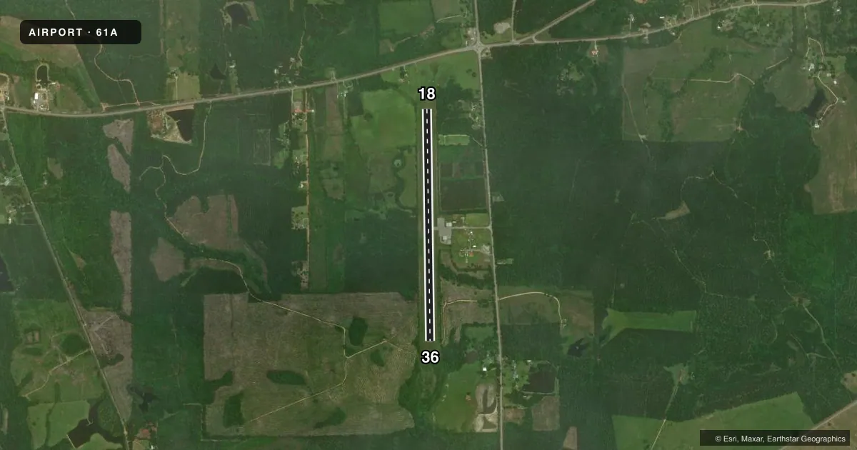
Runways & pattern
Full pagePattern entry · RWY 36
LEFT TRAFFICRunway end performance
| End | TORA | TODA | ASDA | LDA | VGSI | Approach lights | Obstruction |
|---|---|---|---|---|---|---|---|
| 18 | — | — | — | — | PAPI 2-box left(3.5°) | — | 9', tree, 270' from thr, 1' R of cntrln, slope 7 |
| 36 | — | — | — | — | PAPI 2-box left(3.5°) | — | 12', tree, 387' from thr, 20' R of cntrln, slope 15 |
Declared distances in feet. TORA = takeoff run available, TODA = takeoff distance, ASDA = accelerate-stop, LDA = landing distance.
Airport sketch
Runways drawn to scale from FAA survey coordinates, rendered over satellite imagery. Not for navigation.
Approaches & charts
Services on the field
Fuel grades, oxygen, maintenance, ramp storage and lighting — as declared to the FAA by the airport operator.
Fuel & services
- Fuel
- Not available
- Oxygen (bottled)
- Not available
- Oxygen (bulk)
- Not available
- Airframe repair
- Not available
- Power plant repair
- Not available
Ramp & ground
- Transient storage
- Tie-down
- Landing fee
- No fee published
- Customs
- Not available
- Lighting schedule
- SEE RMK
- Beacon schedule
- SS-SR
- Beacon
- White / Green (civil land)(WG)
- Wind indicator
- Lighted
- Segmented circle
- No
Fuel & FBOs
Cheapest 100LL and Jet A on the field and nearby. Always confirm with the FBO before taxi.
Airport notes
Surface conditions, obstructions, local procedures, lighting outages and other notes published with each FAA cycle.
General notes
- FOR CD CTC ATLANTA ARTCC AT 770-210-7692.
Lighting notes
- ACTVT PAPI RWY 18 & 36; MIRL RWY 18/36 - CTAF.
Other notes
- VFR OPNS ONLY.
- 18/36RWY SFC TREATMENT HAS FADED/STREAKED THRUT RWY PAVEMENT SFCS.
VFR map & nearby airports
VFR sectional. Tap any ICAO chip to open that airport.
Key facts · 61A
Answer card- ICAO
- 61A
- Name
- CAMDEN MUNI
- Location
- CAMDEN, ALABAMA
- Elevation
- 142.9 ft MSL
- Traffic pattern altitude
- 1,142.9 ft MSL (1,000 AGL)
- Control tower
- Non-towered (use CTAF)
- Total runways
- 1
- Longest runway
- 18/36 · 4,303 ft
- Published ILS approaches
- 0
- Published frequencies
- 1
- Magnetic variation
- 3°
- Current flight rules
- VFR
- Current wind
- 290° at 3 kt
- Favored runway now
- RWY 36
Camden Muni is in Camden, Alabama. The field elevation is 142.9 ft MSL. It has one runway. Runway 18/36 is 4,303 ft of asphalt, so it is the runway to plan around here.
There is no control tower. CTAF is 122.9. Published remarks say the airport is VFR only. For clearance delivery, contact Atlanta ARTCC at 770-210-7692. The runway has PAPI on both ends. Medium intensity runway lights are also published for 18 and 36. They are controlled by CTAF.
No ILS approaches are published. Pattern altitude is not published, so use the current Chart Supplement before you go. The runway surface treatment is reported as faded and streaked across the pavement. That is worth a close look on rollout and during the takeoff roll.
No on-field FBOs are listed in the facts. Check with the airport operator or the FBO directly by phone before arrival if you need fuel or ramp details. For a first-time pilot, the main things here are simple. Plan for non-towered VFR ops. Brief the runway lighting control on CTAF. Verify current pattern altitude and any local procedures before departure.