METAR & TAF KMVC
KMVC does not publish a METAR.
Showing the nearest reporting station: KGZH (EVERGREEN RGNL/MIDDLETON FLD) · 16.0 NM away. Conditions at KMVC may differ.
METAR · KGZH
Observed 11:53Z
KGZH 271153Z AUTO 00000KT 10SM CLR 25/23 A2995 RMK AO2 SLP139 T02500233 10250 20233 53009
- Wind
- 000° @ 0 kt
- Visibility
- 10 SM
- Temp / Dew
- 25°C / 23°C
- Altimeter
- 29.95 inHg
- Clouds
- CLR
- Density alt
- 1,682 ft
- Ceiling
- Unlimited
- Rules
- VFR
Airport info & contacts
Manager on record, flight service, ARTCC, attendance schedule and pattern altitude — published by the FAA and refreshed every 28 days.
Location
- From city
- 3 NM S
- VFR sectional
- NEW ORLEANS
- ARTCC
- ZTL · ATLANTA
- NOTAM facility
- ANB (NOTAM-D)
Airport manager
- Name
- JASON WELCH
- Phone
- 251-593-6828
- Address
- PO BOX 191, MONROEVILLE AL 36461
Flight service · Hours
- FSS ANB
- ANNISTON1-800-WX-BRIEF
- Attendance
- MON-FRI · 0800-2000
- SAT-SUN · 0800-1700
Frequencies
Tap any row to copy the frequency to your clipboard.
Runways & pattern
Full pagePattern entry · RWY 03
LEFT TRAFFICRunway end performance
| End | TORA | TODA | ASDA | LDA | VGSI | Approach lights | Obstruction |
|---|---|---|---|---|---|---|---|
| 03 | — | — | — | — | PAPI 4-box left(3°) | — | 73', tree, 858' from thr, 337' R of cntrln, slope 9 |
| 21 | — | — | — | — | PAPI 4-box left(3°) | — | 79', tree, 848' from thr, 342' R of cntrln, slope 8 |
Declared distances in feet. TORA = takeoff run available, TODA = takeoff distance, ASDA = accelerate-stop, LDA = landing distance.
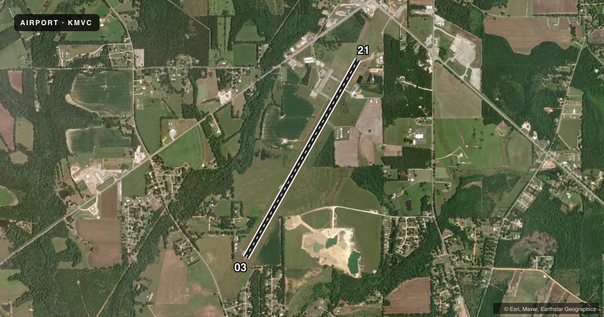
Airport sketch
Runways drawn to scale from FAA survey coordinates, rendered over satellite imagery. Not for navigation.
Approaches & charts
Services on the field
Fuel grades, oxygen, maintenance, ramp storage and lighting — as declared to the FAA by the airport operator.
Fuel & services
- Fuel
- 100LLA+
- Oxygen (bottled)
- Not available
- Oxygen (bulk)
- Not available
- Airframe repair
- Not available
- Power plant repair
- Not available
Ramp & ground
- Transient storage
- Tie-down
- Landing fee
- No fee published
- Customs
- Not available
- Lighting schedule
- SEE RMK
- Beacon schedule
- SS-SR
- Beacon
- White / Green (civil land)(WG)
- Wind indicator
- Lighted
- Segmented circle
- No
Fuel & FBOs
Cheapest 100LL and Jet A on the field and nearby. Always confirm with the FBO before taxi.
Airport notes
Surface conditions, obstructions, local procedures, lighting outages and other notes published with each FAA cycle.
Lighting notes
- ACTVT REIL RWY 03 & 21; PAPI RWY 03 & 21 - CTAF.
Other notes
- THIS AIRPORT HAS BEEN SURVEYED BY THE NATIONAL GEODETIC SURVEY.
- MANAGERADDL CTC FBO MATT OKULY, MONROEVILLE AVIATION AT 251-575-4235.
- 03/21CRACKING ON RWY
VFR map & nearby airports
VFR sectional. Tap any ICAO chip to open that airport.
Key facts · KMVC
Answer card- ICAO
- KMVC
- Name
- MONROE COUNTY AEROPLEX
- Location
- MONROEVILLE, ALABAMA
- Elevation
- 419.1 ft MSL
- Traffic pattern altitude
- 1,419.1 ft MSL (1,000 AGL)
- Control tower
- Non-towered (use CTAF)
- Total runways
- 1
- Longest runway
- 03/21 · 6,028 ft
- Published ILS approaches
- 0
- Published frequencies
- 2
- Magnetic variation
- 2°
- Current flight rules
- VFR
- Current wind
- 000° at 0 kt
- Favored runway now
- –
Monroe County Aeroplex sits in Monroeville, Alabama. Field elevation is 419.1 ft MSL. The airport has one runway. Runway 03/21 is 6,028 ft long and asphalt. The runway headings are magnetic 30° and 210°. There is no control tower. CTAF and UNICOM are both 123.0.
No ILS approaches are published here. Pattern altitude is not published, so use the standard 1,000 ft AGL for light piston traffic unless the current FAA Chart Supplement says otherwise. The field has been surveyed by the National Geodetic Survey. Runway 03/21 has reported cracking, so expect a normal preflight scan of the pavement and pay attention to any surface issues on rollout and taxi.
Monroeville Aviation is on the field. It carries 100LL and Jet A. If you need current ramp or service details, call them at (251) 575-4235. Runway end identifier lights are active on 03 and 21. PAPI is also installed on both ends and is controlled on CTAF. For a first-time arrival, check the current Chart Supplement for any local notes before you go. This is an uncontrolled field, so listen early, make your calls and build a clean pattern entry.