METAR & TAF 5R1
5R1 does not publish a METAR.
Showing the nearest reporting station: KMOB (MOBILE RGNL) · 45.7 NM away. Conditions at 5R1 may differ.
METAR · KMOB
Observed 12:56Z
KMOB 271256Z VRB05KT 10SM FEW050 BKN110 BKN250 28/24 A3000 RMK AO2 SLP154 T02830244
- Wind
- VAR @ 5 kt
- Visibility
- 10 SM
- Temp / Dew
- 28°C / 24°C
- Altimeter
- 30.00 inHg
- Clouds
- BKN
- Density alt
- 1,667 ft
- Ceiling
- 11,000 ft AGL
- Rules
- VFR
Airport info & contacts
Manager on record, flight service, ARTCC, attendance schedule and pattern altitude — published by the FAA and refreshed every 28 days.
Location
- From city
- 3 NM E
- VFR sectional
- NEW ORLEANS
- ARTCC
- ZHU · HOUSTON
- NOTAM facility
- ANB (NOTAM-D)
Airport manager
- Name
- PATRICK FLANAGAN
- Phone
- 251-510-0533
- Address
- CHATOM AL 36518
Flight service · Hours
- FSS ANB
- ANNISTON1-800-WX-BRIEF
- Attendance
- Unattended
Frequencies
Tap any row to copy the frequency to your clipboard.
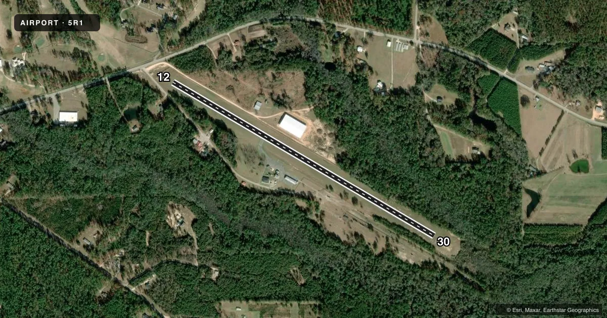
Runways & pattern
Full pagePattern entry · RWY 30
LEFT TRAFFICRunway end performance
| End | TORA | TODA | ASDA | LDA | VGSI | Approach lights | Obstruction |
|---|---|---|---|---|---|---|---|
| 30 | — | — | — | — | — | — | 57', trees, 784' from thr, 175' R of cntrln, slope 10 |
Declared distances in feet. TORA = takeoff run available, TODA = takeoff distance, ASDA = accelerate-stop, LDA = landing distance.
Airport sketch
Runways drawn to scale from FAA survey coordinates, rendered over satellite imagery. Not for navigation.
Approaches & charts
Services on the field
Fuel grades, oxygen, maintenance, ramp storage and lighting — as declared to the FAA by the airport operator.
Fuel & services
- Fuel
- Not available
- Other services
- INSTR,RNTL
Ramp & ground
- Transient storage
- Tie-down
- Landing fee
- No fee published
- Customs
- Not available
- Lighting schedule
- SEE RMK
- Beacon schedule
- SEE RMK
- Beacon
- White / Green (civil land)(WG)
- Wind indicator
- Lighted
- Segmented circle
- No
Fuel & FBOs
Cheapest 100LL and Jet A on the field and nearby. Always confirm with the FBO before taxi.
Airport notes
Surface conditions, obstructions, local procedures, lighting outages and other notes published with each FAA cycle.
General notes
- DEER ON & INVOF RWY.
- FOR CD CTC HOUSTON ARTCC AT 281-230-5622.
Lighting notes
- MIRL RWY 12/30 OPR DUSK TO DAWN.
Approach & departure obstructions
- 12RWY 12 APCH RATIO 27:1 FM DSPLCD THR.
Other notes
- BEFORE FAA ACT.
VFR map & nearby airports
VFR sectional. Tap any ICAO chip to open that airport.
Key facts · 5R1
Answer card- ICAO
- 5R1
- Name
- ROY WILCOX
- Location
- CHATOM, ALABAMA
- Elevation
- 166 ft MSL
- Traffic pattern altitude
- 1,166 ft MSL (1,000 AGL)
- Control tower
- Non-towered (use CTAF)
- Total runways
- 1
- Longest runway
- 12/30 · 4,002 ft
- Published ILS approaches
- 0
- Published frequencies
- 2
- Magnetic variation
- 1°
- Current flight rules
- VFR
- Current wind
- 000° at 5 kt
- Favored runway now
- RWY 30
Roy Wilcox Airport (5R1) sits in Chatom, Alabama. Field elevation is 166 ft MSL. The airport has one runway. Runway 12/30 is 4,002 ft of asphalt. There is no control tower, so plan for self-announce ops on CTAF 122.8. No ILS approaches are published here.
Pattern altitude is not published. Use the standard 1,000 ft AGL pattern for light piston traffic unless current local guidance says otherwise. The published remarks also note medium intensity runway lights on 12/30 that operate from dusk to dawn. There is a displaced threshold note for runway 12, so pay attention to the available landing distance on that end. Deer are reported on and near the runway. That is the kind of local hazard that deserves a careful scan on taxi, takeoff and final.
There are no on-field FBOs listed in the facts. Fuel availability should be confirmed with the airport operator or by calling the field directly before arrival. For clearance delivery, Houston ARTCC is listed in the remarks. If you are planning IFR or a night arrival, verify the current Chart Supplement before departure. The field is small, uncontrolled and simple on paper. The main things to brief are the runway lighting, the deer hazard and the displaced-threshold note on runway 12.