METAR & TAF M59
M59 does not publish a METAR.
Showing the nearest reporting station: KHBG (HATTIESBURG BOBBY L CHAIN MUNI) · 16.6 NM away. Conditions at M59 may differ.
METAR · KHBG
Observed 17:53Z
KHBG 261753Z AUTO 10SM SCT050 34/23 A3004 RMK AO2 SLP168 T03390228 10344 20261 58008 $
- Wind
- Calm
- Visibility
- 10 SM
- Temp / Dew
- 34°C / 23°C
- Altimeter
- 30.04 inHg
- Clouds
- SCT
- Density alt
- 2,338 ft
- Ceiling
- Unlimited
- Rules
- VFR
Airport info & contacts
Manager on record, flight service, ARTCC, attendance schedule and pattern altitude — published by the FAA and refreshed every 28 days.
Location
- From city
- 2 NM S
- VFR sectional
- NEW ORLEANS
- ARTCC
- ZHU · HOUSTON
- NOTAM facility
- GWO (NOTAM-D)
Airport manager
- Name
- JIMMY WALTERS
- Phone
- 601-788-7770
- Address
- PO BOX 1649, RICHTON MS 39476
Flight service · Hours
- FSS GWO
- GREENWOOD1-800-WX-BRIEF
- Attendance
- Unattended
Frequencies
Tap any row to copy the frequency to your clipboard.
Runways & pattern
Full pagePattern entry · RWY 18
LEFT TRAFFICRunway end performance
| End | TORA | TODA | ASDA | LDA | VGSI | Approach lights | Obstruction |
|---|---|---|---|---|---|---|---|
| 18 | — | — | — | — | PAPI 2-box left | — | 85', trees, 1600' from thr, 250' R of cntrln, slope 16 |
| 36 | — | — | — | — | PAPI 2-box left | — | 65', trees, 1200' from thr, 0' R of cntrln, slope 15 |
Declared distances in feet. TORA = takeoff run available, TODA = takeoff distance, ASDA = accelerate-stop, LDA = landing distance.
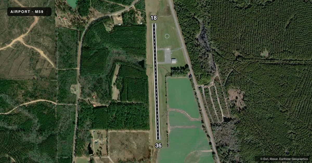
Airport sketch
Runways drawn to scale from FAA survey coordinates, rendered over satellite imagery. Not for navigation.
Approaches & charts
Services on the field
Fuel grades, oxygen, maintenance, ramp storage and lighting — as declared to the FAA by the airport operator.
Fuel & services
- Fuel
- Not available
- Oxygen (bottled)
- Not available
- Oxygen (bulk)
- Not available
- Airframe repair
- Not available
- Power plant repair
- Not available
- Other services
- AGRI
Ramp & ground
- Transient storage
- Tie-down
- Landing fee
- No fee published
- Customs
- Not available
- Lighting schedule
- SEE RMK
- Beacon schedule
- SEE RMK
- Beacon
- White / Green (civil land)(WG)
- Wind indicator
- Lighted
- Segmented circle
- Yes
Fuel & FBOs
Cheapest 100LL and Jet A on the field and nearby. Always confirm with the FBO before taxi.
Airport notes
Surface conditions, obstructions, local procedures, lighting outages and other notes published with each FAA cycle.
General notes
- FOR CD CTC HOUSTON ARTCC AT 281-230-5622.
Lighting notes
- OTS INDEFLY.
- ACTVT PAPI RWY 18 & 36; MIRL 18/36 - CTAF.
Approach & departure obstructions
- 18RWY MRKGS FADED.
- 36RWY MRKGS FADED.
Other notes
- VFR ONLY.
- PILOTS MUST PRVD TIEDOWN ROPES.
- MANAGER601-788-6015.
VFR map & nearby airports
VFR sectional. Tap any ICAO chip to open that airport.
Key facts · M59
Answer card- ICAO
- M59
- Name
- RICHTON-PERRY COUNTY
- Location
- RICHTON, MISSISSIPPI
- Elevation
- 167 ft MSL
- Traffic pattern altitude
- 1,167 ft MSL (1,000 AGL)
- Control tower
- Non-towered (use CTAF)
- Total runways
- 1
- Longest runway
- 18/36 · 3,000 ft
- Published ILS approaches
- 0
- Published frequencies
- 1
- Magnetic variation
- 2°
- Current flight rules
- VFR
- Current wind
- Calm / unavailable
- Favored runway now
- –
Richton-Perry County Airport sits in Richton, Mississippi. Field elevation is 167 ft MSL. The airport has one runway. Runway 18/36 is 3,000 ft long with asphalt pavement. The field is non-towered. CTAF is 122.9.
No ILS approaches are published here. This is a VFR-only field, so plan accordingly. The published pattern altitude is not listed. Use the standard 1,000 ft AGL pattern unless current local guidance says otherwise. The runway markings on both ends are reported as faded. PAPI is available for runways 18 and 36. Medium intensity runway lights for 18 and 36 are activated on the CTAF. The beacon is on the schedule indefinitely.
There are no on-field FBOs listed. Pilots should bring tiedown ropes, since the airport notes that they must be provided by the pilot. For clearance delivery, contact Houston ARTCC at 281-230-5622. If you are planning a first stop here, check the current Chart Supplement and call the airport operator before departure for any local updates. The runway is short enough that performance planning matters, especially on hot Mississippi days.