METAR & TAF 00M
00M does not publish a METAR.
Showing the nearest reporting station: KLUL (HESLER/NOBLE FLD) · 17.2 NM away. Conditions at 00M may differ.
METAR · KLUL
Observed 16:15Z
KLUL 261615Z AUTO 31009KT 10SM CLR 33/23 A3006 RMK A02 T03290233
- Wind
- 310° @ 9 kt
- Visibility
- 10 SM
- Temp / Dew
- 33°C / 23°C
- Altimeter
- 30.06 inHg
- Clouds
- CLR
- Density alt
- 2,422 ft
- Ceiling
- Unlimited
- Rules
- VFR
Airport info & contacts
Manager on record, flight service, ARTCC, attendance schedule and pattern altitude — published by the FAA and refreshed every 28 days.
Location
- From city
- 3 NM SE
- VFR sectional
- NEW ORLEANS
- ARTCC
- ZME · MEMPHIS
- NOTAM facility
- GWO (NOTAM-D)
Airport manager
- Name
- DONALD BROWN
- Phone
- 601-670-1523
- Address
- PO BOX 307, BAY SPRINGS MS 39422
Flight service · Hours
- FSS GWO
- GREENWOOD1-800-WX-BRIEF
- Attendance
- UNATTENDED
Frequencies
Tap any row to copy the frequency to your clipboard.
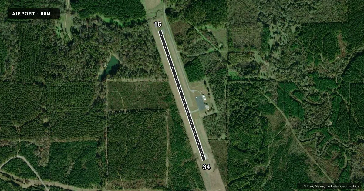
Runways & pattern
Full pagePattern entry · RWY 34
LEFT TRAFFICRunway end performance
| End | TORA | TODA | ASDA | LDA | VGSI | Approach lights | Obstruction |
|---|---|---|---|---|---|---|---|
| 16 | — | — | — | — | — | — | 65', tree, 1980' from thr, 250' R of cntrln, slope 27 |
| 34 | — | — | — | — | — | — | 165', trees, 4000' from thr, slope 23 |
Declared distances in feet. TORA = takeoff run available, TODA = takeoff distance, ASDA = accelerate-stop, LDA = landing distance.
Airport sketch
Runways drawn to scale from FAA survey coordinates, rendered over satellite imagery. Not for navigation.
Approaches & charts
Services on the field
Fuel grades, oxygen, maintenance, ramp storage and lighting — as declared to the FAA by the airport operator.
Fuel & services
- Fuel
- Not available
- Oxygen (bottled)
- Not available
- Oxygen (bulk)
- Not available
- Other services
- AGRI
Ramp & ground
- Transient storage
- Tie-down
- Landing fee
- No fee published
- Customs
- Not available
- Lighting schedule
- SS-SR
- Beacon schedule
- SS-SR
- Beacon
- White / Green (civil land)(WG)
- Wind indicator
- Lighted
- Segmented circle
- Yes
Fuel & FBOs
Cheapest 100LL and Jet A on the field and nearby. Always confirm with the FBO before taxi.
Airport notes
Surface conditions, obstructions, local procedures, lighting outages and other notes published with each FAA cycle.
General notes
- TREES ON EAST AND WEST SIDES OF RY VIOLATE TRANSITIONAL SFC.
- FOR CD CTC MEMPHIS ARTCC AT 901-368-8453/8449.
Other notes
- PILOTS MUST PROVIDE THEIR OWN TIEDOWN ROPES.
VFR map & nearby airports
VFR sectional. Tap any ICAO chip to open that airport.
Key facts · 00M
Answer card- ICAO
- 00M
- Name
- THIGPEN FLD
- Location
- BAY SPRINGS, MISSISSIPPI
- Elevation
- 351 ft MSL
- Traffic pattern altitude
- 1,351 ft MSL (1,000 AGL)
- Control tower
- Non-towered (use CTAF)
- Total runways
- 1
- Longest runway
- 16/34 · 3,000 ft
- Published ILS approaches
- 0
- Published frequencies
- 1
- Magnetic variation
- 2°
- Current flight rules
- VFR
- Current wind
- 310° at 9 kt
- Favored runway now
- RWY 34
Thigpen Fld is in Bay Springs, Mississippi. The field elevation is 351 ft MSL. It has one runway, 16/34, which is 3,000 ft long with an asphalt surface. The airport is non-towered. CTAF is 122.9.
No ILS approaches are published here. Pattern altitude is not published. Use standard 1,000 ft AGL for light piston traffic unless the current Chart Supplement says otherwise. The runway headings are magnetic. Runway 16 is 161°. Runway 34 is 341°.
There are no on-field FBOs listed in the facts. Plan on self-sufficiency for arrival and ground handling. Pilots should also note the published remarks. Trees on the east and west sides of the runway penetrate the transitional surface. That matters on climb-out and on short final. The remarks also say pilots must provide their own tiedown ropes. For clearance delivery, contact Memphis ARTCC at 901-368-8453 or 901-368-8449. If you need current operational details, check the current FAA Chart Supplement or call the airport operator before departure.