METAR & TAF KPIB
Current METAR
Observed 05:56Z
KPIB 270556Z AUTO 00000KT 10SM CLR 25/24 A3000 RMK AO2 SLP154 T02500239 10356 20250 403780239 50008 PWINO $
- Wind
- 000° @ 0 kt
- Visibility
- 10 SM
- Temp / Dew
- 25°C / 24°C
- Altimeter
- 30.00 inHg
- Clouds
- CLR
- Density alt
- 1,470 ft
- Ceiling
- Unlimited
- Rules
- VFR
Airport info & contacts
Manager on record, flight service, ARTCC, attendance schedule and pattern altitude — published by the FAA and refreshed every 28 days.
Location
- From city
- 9 NM N
- VFR sectional
- NEW ORLEANS
- ARTCC
- ZHU · HOUSTON
- NOTAM facility
- PIB (NOTAM-D)
Airport manager
- Name
- THOMAS HEANUE
- Phone
- 601-545-3111
- Address
- 1002 TERMINAL DR, MOSELLE MS 39459
Flight service · Hours
- FSS GWO
- GREENWOOD1-800-WX-BRIEF
- Attendance
- 0500-2300
Frequencies
Tap any row to copy the frequency to your clipboard.
Runways & pattern
Full pagePattern entry · RWY 18
LEFT TRAFFICRunway end performance
| End | TORA | TODA | ASDA | LDA | VGSI | Approach lights | Obstruction |
|---|---|---|---|---|---|---|---|
| 18 | 6,503' | 6,503' | 6,503' | 6,503' | PAPI 4-box left(3°) | MALSR | — |
| 36 | 6,503' | 6,503' | 6,503' | 6,503' | PAPI 4-box left(3°) | — | — |
Declared distances in feet. TORA = takeoff run available, TODA = takeoff distance, ASDA = accelerate-stop, LDA = landing distance.
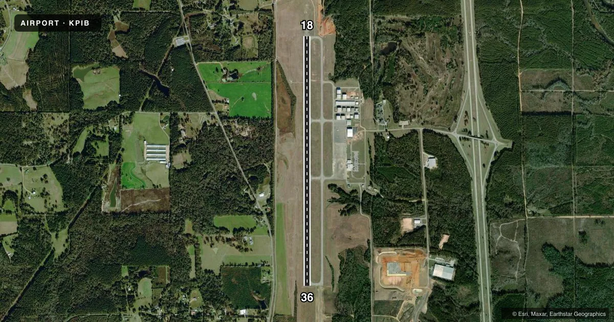
Airport sketch
Runways drawn to scale from FAA survey coordinates, rendered over satellite imagery. Not for navigation.
Approaches & charts
ILS · 1
Services on the field
Fuel grades, oxygen, maintenance, ramp storage and lighting — as declared to the FAA by the airport operator.
Fuel & services
- Fuel
- 100A
- Oxygen (bottled)
- Not available
- Oxygen (bulk)
- Not available
- Airframe repair
- Minor
- Power plant repair
- Minor
- Other services
- INSTR,RNTL
Ramp & ground
- Transient storage
- Tie-down
- Hangar
- Landing fee
- No fee published
- Customs
- Not available
- Lighting schedule
- SEE RMK
- Beacon schedule
- SS-SR
- Beacon
- White / Green (civil land)(WG)
- Wind indicator
- Lighted
- Segmented circle
- Yes
Fuel & FBOs
Cheapest 100LL and Jet A on the field and nearby. Always confirm with the FBO before taxi.
Airport notes
Surface conditions, obstructions, local procedures, lighting outages and other notes published with each FAA cycle.
General notes
- FOR CD CTC HOUSTON ARTCC AT 281-230-5622.
Lighting notes
- ACTVT MALSR RWY 18; REILS RWY 18 & 36; HIRL RWY 18/36 - CTAF. HIRL RWY 18/36 PRESET TO MED INTST, TO INCRS INTST - CTAF. PAPIS RWY 18 & 36 OPR CONSLY.
Runway surface & condition
- 18/36PCR VALUE: 860/F/C/X/T
Other notes
- CLSD TO ACR OPS WITH MORE THAN 30 PAX SEATS EXCP 24 HR PPR, CALL ARPT MGR 601-545-3111.
- OWNERHATTIESBURG-LAUREL REGIONAL AIRPORT AUTHORITY.
VFR map & nearby airports
VFR sectional. Tap any ICAO chip to open that airport.
Key facts · KPIB
Answer card- ICAO
- KPIB
- Name
- HATTIESBURG/LAUREL RGNL
- Location
- HATTIESBURG-LAUREL, MISSISSIPPI
- Elevation
- 297.6 ft MSL
- Traffic pattern altitude
- 1,297.6 ft MSL (1,000 AGL)
- Control tower
- Non-towered (use CTAF)
- Total runways
- 1
- Longest runway
- 18/36 · 6,503 ft
- Published ILS approaches
- 1
- Published frequencies
- 2
- Magnetic variation
- 1°
- Current flight rules
- VFR
- Current wind
- 000° at 0 kt
- Favored runway now
- –
Hattiesburg/Laurel Rgnl sits in Hattiesburg-Laurel, Mississippi. Field elevation is 297.6 ft MSL. The airport has one runway, 18/36, which is 6,503 ft long. There is no control tower, so expect self-announce traffic on CTAF 123.0. The published pattern altitude is not listed. Use the standard 1,000 ft AGL for light piston operations unless the current Chart Supplement says otherwise.
Runway 18 has an ILS. The field also has MALSR on runway 18, with REILs on both ends. High intensity runway lights are on runways 18 and 36. They are controlled on CTAF. The lights start at medium intensity. You can increase intensity by keying the CTAF. PAPI is listed on both runway ends and operates continuously.
Avflight Hattiesburg is on the field. It carries 100LL, Jet A and Jet A Prist. For clearance delivery, contact Houston ARTCC at 281-230-5622. The airport is owned by the Hattiesburg-Laurel Regional Airport Authority. One operational note matters for larger aircraft. The field is closed to aircraft rescue and fire fighting operations with more than 30 passenger seats unless 24-hour prior permission is obtained from the airport manager. The runway pavement rating is also published for 18/36, so verify aircraft compatibility before arrival.