METAR & TAF KHBG
Current METAR
Observed 11:53Z
KHBG 271153Z AUTO 29003KT 10SM OVC090 26/24 A2999 RMK AO2 SLP152 T02560239 10267 20250 53013 $
- Wind
- 290° @ 3 kt
- Visibility
- 10 SM
- Temp / Dew
- 26°C / 24°C
- Altimeter
- 29.99 inHg
- Clouds
- OVC
- Density alt
- 1,420 ft
- Ceiling
- 9,000 ft AGL
- Rules
- VFR
Airport info & contacts
Manager on record, flight service, ARTCC, attendance schedule and pattern altitude — published by the FAA and refreshed every 28 days.
Location
- From city
- 4 NM SE
- VFR sectional
- NEW ORLEANS
- ARTCC
- ZHU · HOUSTON
- NOTAM facility
- HBG (NOTAM-D)
Airport manager
- Name
- MS MARYBETH BERGIN
- Phone
- (601) 544-8661
- Address
- PO BOX 1898, HATTIESBURG MS 39401
Flight service · Hours
- FSS GWO
- GREENWOOD1-800-WX-BRIEF
- Attendance
- DALGT
Frequencies
Tap any row to copy the frequency to your clipboard.
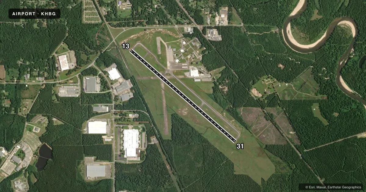
Runways & pattern
Full pagePattern entry · RWY 31
LEFT TRAFFICRunway end performance
| End | TORA | TODA | ASDA | LDA | VGSI | Approach lights | Obstruction |
|---|---|---|---|---|---|---|---|
| 13 | — | — | — | — | PAPI 4-box left(3°) | — | 35', trees, 1400' from thr, slope 34 |
| 31 | — | — | — | — | PAPI 4-box left(3°) | — | 59', trees, 3200' from thr, 0' R of cntrln, slope 50 |
Declared distances in feet. TORA = takeoff run available, TODA = takeoff distance, ASDA = accelerate-stop, LDA = landing distance.
Airport sketch
Runways drawn to scale from FAA survey coordinates, rendered over satellite imagery. Not for navigation.
Approaches & charts
Services on the field
Fuel grades, oxygen, maintenance, ramp storage and lighting — as declared to the FAA by the airport operator.
Fuel & services
- Fuel
- 100LLA
- Oxygen (bottled)
- High pressure
- Oxygen (bulk)
- Not available
- Airframe repair
- Major
- Power plant repair
- Major
- Other services
- INSTR,RNTL
Ramp & ground
- Transient storage
- Tie-down
- Hangar
- Landing fee
- No fee published
- Customs
- Not available
- Lighting schedule
- SEE RMK
- Beacon schedule
- SS-SR
- Beacon
- White / Green (civil land)(WG)
- Wind indicator
- Lighted
- Segmented circle
- Yes
Fuel & FBOs
Cheapest 100LL and Jet A on the field and nearby. Always confirm with the FBO before taxi.
Airport notes
Surface conditions, obstructions, local procedures, lighting outages and other notes published with each FAA cycle.
General notes
- RUN-ON LDG BY SKID HEL ARE NOT ALLOWED.
- FOR CD CTC HOUSTON ARTCC AT 281-230-5622.
Lighting notes
- ACTVT REIL RWY 13; MIRL RWY 13/31 - CTAF. PAPI RWY 13 & 31 OPR CONSLY.
Approach & departure obstructions
- 13APCH RATIO 50:1 TO DTHR; FM +61 FT TREES; 2396 FT FM DTHR.
Other notes
- INSTRCOURTESY CAR, TAXIS, PUBLIC BUS (WKDAYS) & RENTAL CARS AVBL.
VFR map & nearby airports
VFR sectional. Tap any ICAO chip to open that airport.
Key facts · KHBG
Answer card- ICAO
- KHBG
- Name
- HATTIESBURG BOBBY L CHAIN MUNI
- Location
- HATTIESBURG, MISSISSIPPI
- Elevation
- 150.8 ft MSL
- Traffic pattern altitude
- 1,150.8 ft MSL (1,000 AGL)
- Control tower
- Non-towered (use CTAF)
- Total runways
- 1
- Longest runway
- 13/31 · 6,094 ft
- Published ILS approaches
- 0
- Published frequencies
- 2
- Magnetic variation
- 1°
- Current flight rules
- VFR
- Current wind
- 290° at 3 kt
- Favored runway now
- RWY 31
Hattiesburg Bobby L Chain Muni sits in Hattiesburg, Mississippi. Field elevation is 150.8 ft MSL. The airport has one runway, 13/31, which is 6,094 ft long. It is an untowered field. CTAF and UNICOM are both 122.8.
No ILS approaches are published here. Pattern altitude is not published, so use the standard 1,000 ft AGL for light piston operations unless the current Chart Supplement says otherwise. Runway 13 has runway end identifier lights. Runways 13 and 31 have medium intensity runway lights on CTAF. The PAPI on both ends operates continuously. There is also a published tree obstruction note near the displaced threshold for runway 13, so pay attention to your approach path on that end.
Southeast Aviation is on the field. It carries 100LL and Jet A. For clearance delivery, contact Houston ARTCC at 281-230-5622. If you are planning a first stop here, expect a normal small-airport setup with no tower. Local traffic uses CTAF. Courtesy car, taxis, public bus service on weekdays and rental cars are available.