METAR & TAF 4R1
4R1 does not publish a METAR.
Showing the nearest reporting station: KHBG (HATTIESBURG BOBBY L CHAIN MUNI) · 19.1 NM away. Conditions at 4R1 may differ.
METAR · KHBG
Observed 09:53Z
KHBG 270953Z AUTO 28004KT 10SM CLR 26/23 A2995 RMK AO2 SLP139 T02560233 $
- Wind
- 280° @ 4 kt
- Visibility
- 10 SM
- Temp / Dew
- 26°C / 23°C
- Altimeter
- 29.95 inHg
- Clouds
- CLR
- Density alt
- 1,667 ft
- Ceiling
- Unlimited
- Rules
- VFR
Airport info & contacts
Manager on record, flight service, ARTCC, attendance schedule and pattern altitude — published by the FAA and refreshed every 28 days.
Location
- From city
- 2 NM NW
- VFR sectional
- NEW ORLEANS
- ARTCC
- ZHU · HOUSTON
- NOTAM facility
- GWO (NOTAM-D)
Airport manager
- Name
- JIM WOELFEL
- Phone
- 907-244-8620
- Address
- 300 N 2ND ST, LUMBERTON MS 39455
Flight service · Hours
- FSS GWO
- GREENWOOD1-800-WX-BRIEF
- Attendance
- Unattended
Frequencies
Tap any row to copy the frequency to your clipboard.
Runways & pattern
Full pagePattern entry · RWY 32
LEFT TRAFFICRunway end performance
| End | TORA | TODA | ASDA | LDA | VGSI | Approach lights | Obstruction |
|---|---|---|---|---|---|---|---|
| 14 | — | — | — | — | PAPI 2-box left | — | 66', trees, 1520' from thr, 0' R of cntrln, slope 20 |
| 32 | — | — | — | — | PAPI 2-box left | — | 40', trees, 1000' from thr, 75' R of cntrln, slope 20 |
Declared distances in feet. TORA = takeoff run available, TODA = takeoff distance, ASDA = accelerate-stop, LDA = landing distance.
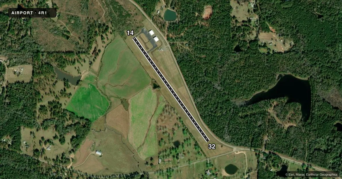
Airport sketch
Runways drawn to scale from FAA survey coordinates, rendered over satellite imagery. Not for navigation.
Approaches & charts
Services on the field
Fuel grades, oxygen, maintenance, ramp storage and lighting — as declared to the FAA by the airport operator.
Fuel & services
- Fuel
- Not available
- Oxygen (bottled)
- Not available
- Oxygen (bulk)
- Not available
- Airframe repair
- Not available
- Power plant repair
- Not available
Ramp & ground
- Transient storage
- Tie-down
- Landing fee
- No fee published
- Customs
- Not available
- Lighting schedule
- SEE RMK
- Beacon schedule
- SS-SR
- Beacon
- White / Green (civil land)(WG)
- Wind indicator
- Lighted
- Segmented circle
- Yes
Fuel & FBOs
Cheapest 100LL and Jet A on the field and nearby. Always confirm with the FBO before taxi.
Airport notes
Surface conditions, obstructions, local procedures, lighting outages and other notes published with each FAA cycle.
General notes
- FOR CD CTC HOUSTON ARTCC AT 281-230-5622.
- PILOTS MUST PRVD THEIR OWN TIEDOWN ROPES.
Lighting notes
- ACTVT PAPI RWY 14 & 32; MIRL RWY 14/32 - CTAF.
Other notes
- MANAGERMAYOR QUINCY ROGERS.
VFR map & nearby airports
VFR sectional. Tap any ICAO chip to open that airport.
Key facts · 4R1
Answer card- ICAO
- 4R1
- Name
- I H BASS JR MEML
- Location
- LUMBERTON, MISSISSIPPI
- Elevation
- 310 ft MSL
- Traffic pattern altitude
- 1,310 ft MSL (1,000 AGL)
- Control tower
- Non-towered (use CTAF)
- Total runways
- 1
- Longest runway
- 14/32 · 3,000 ft
- Published ILS approaches
- 0
- Published frequencies
- 2
- Magnetic variation
- 2°
- Current flight rules
- VFR
- Current wind
- 280° at 4 kt
- Favored runway now
- RWY 32
I H Bass Jr Meml Airport (4R1) sits in Lumberton, Mississippi. The field elevation is 310 ft MSL. It has one runway. Runway 14/32 is 3,000 ft of asphalt, so plan your performance with that length in mind. There is no control tower. CTAF and UNICOM are both 122.8.
No ILS approaches are published here. Pattern altitude is not published, so use the standard 1,000 ft AGL for light piston operations unless the current Chart Supplement says otherwise. That puts the pattern at 1,310 ft MSL based on the field elevation. The published runway lighting note says to activate the PAPI for runway 14 and 32. It also says to use the medium intensity runway lights on 14/32 by radio on the common traffic advisory frequency.
There are no on-field FBOs listed, so verify fuel and service options before you go. The published remarks also say pilots must bring their own tiedown ropes. For clearance delivery, contact Houston ARTCC at 281-230-5622. This is a small non-towered field, so keep your radio work tight and check the current Chart Supplement for any other local procedures before arrival.