METAR & TAF KMJD
Current METAR
Observed 16:35Z
KMJD 131635Z AUTO 00000G10KT 8SM SCT013 24/20 A3005 RMK AO2
- Wind
- 000° @ 0G10 kt
- Visibility
- 8 SM
- Temp / Dew
- 24°C / 20°C
- Altimeter
- 30.05 inHg
- Clouds
- SCT
- Density alt
- 987 ft
- Ceiling
- Unlimited
- Rules
- VFR
Airport info & contacts
Manager on record, flight service, ARTCC, attendance schedule and pattern altitude — published by the FAA and refreshed every 28 days.
Location
- From city
- 2 NM SE
- VFR sectional
- NEW ORLEANS
- ARTCC
- ZHU · HOUSTON
- NOTAM facility
- GWO (NOTAM-D)
Airport manager
- Name
- WAYNE WILSON
- Phone
- 601-590-0260
- Address
- 148 RUNWAY RD, PICAYUNE MS 39466
Flight service · Hours
- FSS GWO
- GREENWOOD1-800-WX-BRIEF
- Attendance
- 0800-1700
Frequencies
Tap any row to copy the frequency to your clipboard.
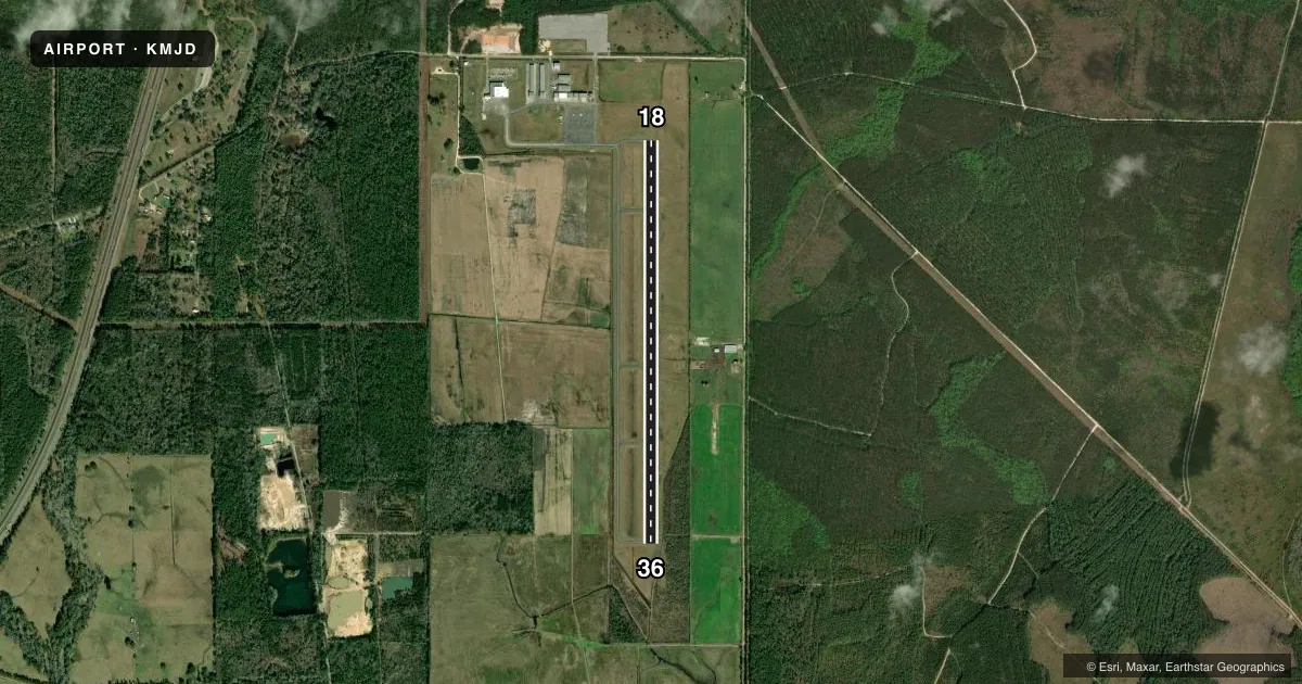
Runways & pattern
Full pagePattern entry · RWY 18
LEFT TRAFFICRunway end performance
| End | TORA | TODA | ASDA | LDA | VGSI | Approach lights | Obstruction |
|---|---|---|---|---|---|---|---|
| 18 | — | — | — | — | PAPI 2-box left(3°) | — | 56', trees, 1715' from thr, 0' R of cntrln, slope 27 |
| 36 | — | — | — | — | PAPI 2-box left(3°) | — | 29', tree, 1200' from thr, 300' R of cntrln, slope 34 |
Declared distances in feet. TORA = takeoff run available, TODA = takeoff distance, ASDA = accelerate-stop, LDA = landing distance.
Airport sketch
Runways drawn to scale from FAA survey coordinates, rendered over satellite imagery. Not for navigation.
Approaches & charts
Services on the field
Fuel grades, oxygen, maintenance, ramp storage and lighting — as declared to the FAA by the airport operator.
Fuel & services
- Fuel
- 100LLA
- Airframe repair
- Major
- Power plant repair
- Major
- Other services
- INSTR
Ramp & ground
- Transient storage
- Tie-down
- Hangar
- Lighting schedule
- SEE RMK
- Beacon schedule
- SS-SR
- Beacon
- White / Green (civil land)(WG)
- Wind indicator
- Lighted
- Segmented circle
- Yes
Fuel & FBOs
Cheapest 100LL and Jet A on the field and nearby. Always confirm with the FBO before taxi.
Airport notes
Surface conditions, obstructions, local procedures, lighting outages and other notes published with each FAA cycle.
General notes
- COURTESY VEHICLE AVBL.
- BIRDS & GEESE INVOF ARPT.
- CK NOTAMS FOR OCNL RSTRD ASP USE BY STENNIS SPACE CNTR.
- FOR CD CTC GULFPORT APCH AT 228-265-6151, WHEN APCH CLSD CTC HOUSTON ARTCC AT 281-230-5622.
Lighting notes
- ACTVT PAPI RWY 18 & 36; MIRL RWY 18/36 - CTAF.
Fuel notes
- 100LLFUEL AVBL 24 HRS WITH CREDIT CARD.
- ACCTV AT TERMINAL AND FUEL PUMPS.
Other notes
- THIS AIRPORT HAS BEEN SURVEYED BY THE NATIONAL GEODETIC SURVEY.
- PRVDD VFR OPNS & EXISTING PICAYUNE ARPT IS CLSD WHEN NEW AIRPORT IS OPNL.
- PILOTS MUST PRVD THEIR OWN TIEDOWN ROPES.
- MANAGERARPT HAS 24 HR LGTD & SCTY CAMERAS AT FUEL-FARM & TRML BLDG. 24 HR ACES FOR PILOTS & PAX AT TRML BLDG. ALTN FONE 601-749-7017.
- OWNERJIM LUKE, CITY MAYOR.
VFR map & nearby airports
VFR sectional. Tap any ICAO chip to open that airport.
Key facts · KMJD
Answer card- ICAO
- KMJD
- Name
- PICAYUNE MUNI
- Location
- PICAYUNE, MISSISSIPPI
- Elevation
- 55.3 ft MSL
- Traffic pattern altitude
- 1,055.3 ft MSL (1,000 AGL)
- Control tower
- Non-towered (use CTAF)
- Total runways
- 1
- Longest runway
- 18/36 · 5,000 ft
- Published ILS approaches
- 0
- Published frequencies
- 4
- Magnetic variation
- 1°
- Current flight rules
- VFR
- Current wind
- 000° at 0 kt
- Favored runway now
- –
Picayune Muni sits in Picayune, Mississippi. The field elevation is 55.3 ft MSL. It has one runway, 18/36, at 5,000 ft asphalt. There is no control tower. Traffic uses CTAF 122.8. No ILS approaches are published here.
Pattern altitude is not published. Use the standard 1,000 ft AGL pattern unless local procedures or NOTAMs say otherwise. The airport is in a low-lying coastal area near the Gulf side of Mississippi, so watch weather, birds and geese in the area. Check NOTAMs for occasional restricted airspace use by Stennis Space Center before you go.
Dispatch Aviation is on the field. It carries AVGAS 100LL and Jet A. Fuel is available 24 hours with credit card. The airport also has 24-hour lighting. Security cameras are at the fuel farm and terminal building. Pilots and passengers have 24-hour access at the terminal. Runway 18/36 lighting is controlled by CTAF. Use the PAPI for both runway ends.
For a first-time arrival, the big items are simple. This is an uncontrolled field with Gulfport Approach frequencies listed for clearance delivery and departure support when available. If approach is closed, contact Houston ARTCC. Pilots must bring their own tiedown ropes. A courtesy vehicle is available.