METAR & TAF KGPT
Current METAR
Observed 11:53Z
KGPT 271153Z 29005KT 10SM CLR 26/24 A2997 RMK AO2 SLP148 T02610244 10289 20261 53008
- Wind
- 290° @ 5 kt
- Visibility
- 10 SM
- Temp / Dew
- 26°C / 24°C
- Altimeter
- 29.97 inHg
- Clouds
- CLR
- Density alt
- 1,293 ft
- Ceiling
- Unlimited
- Rules
- VFR
Airport info & contacts
Manager on record, flight service, ARTCC, attendance schedule and pattern altitude — published by the FAA and refreshed every 28 days.
Location
- From city
- 3 NM NE
- VFR sectional
- NEW ORLEANS
- Pattern altitude
- 800 ft AGL · 828 ft MSL
- ARTCC
- ZHU · HOUSTON
- NOTAM facility
- GPT (NOTAM-D)
Airport manager
- Name
- CLAY WILLIAMS
- Phone
- 228-863-5951
- Address
- 14035-L AIRPORT RD, GULFPORT MS 39503
Flight service · Hours
- FSS GWO
- GREENWOOD1-800-WX-BRIEF
- Attendance
- ALL
Frequencies
Tap any row to copy the frequency to your clipboard.
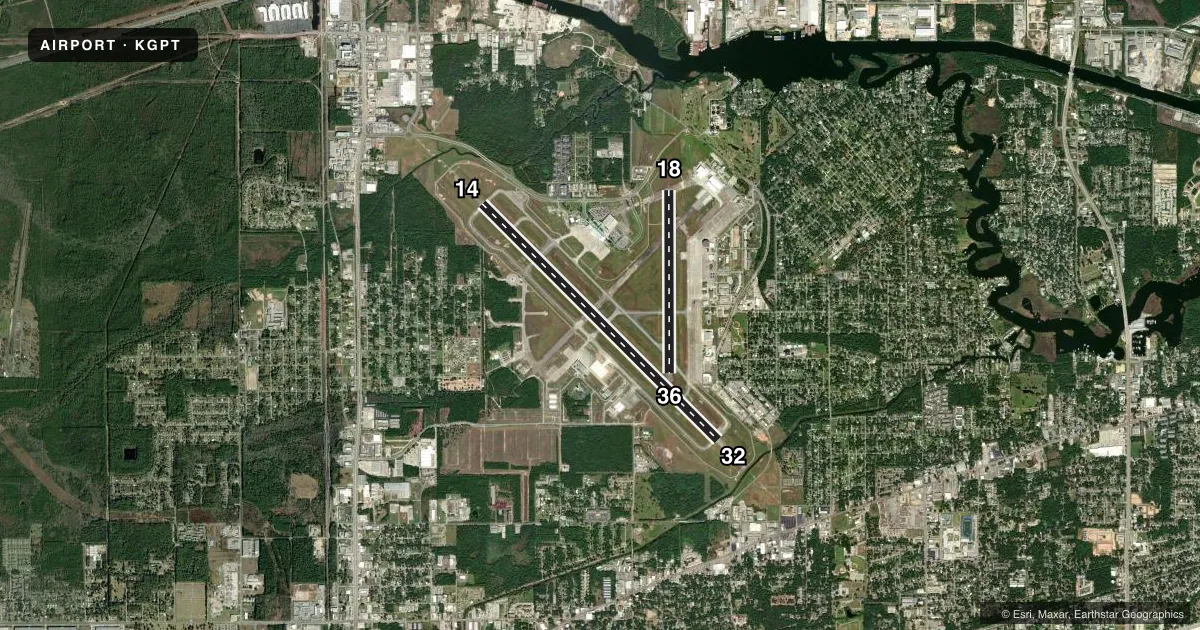
Runways & pattern
Full pagePattern entry · RWY 32
LEFT TRAFFIC| Runway | Heading (°M) | Length | Surface | Traffic |
|---|---|---|---|---|
| 14/32Favored | 133° / 313° | 9,002 ft | ASPH-CONC | Standard L |
| 18/36 | 178° / 358° | 4,935 ft | ASPH | Standard L |
Runway end performance
| End | TORA | TODA | ASDA | LDA | VGSI | Approach lights | Obstruction |
|---|---|---|---|---|---|---|---|
| 14 | — | — | — | — | PAPI 4-box right(3°) | MALSR | — |
| 32 | — | — | — | — | PAPI 4-box left(3°) | MALSR | — |
| 18 | — | — | — | — | PAPI 4-box right(3°) | — | — |
| 36 | — | — | — | — | PAPI 4-box left(3°) | — | — |
Declared distances in feet. TORA = takeoff run available, TODA = takeoff distance, ASDA = accelerate-stop, LDA = landing distance.
Airport sketch
Runways drawn to scale from FAA survey coordinates, rendered over satellite imagery. Not for navigation.
Approaches & charts
ILS · 2
Services on the field
Fuel grades, oxygen, maintenance, ramp storage and lighting — as declared to the FAA by the airport operator.
Fuel & services
- Fuel
- 100LLAA+
- Oxygen (bottled)
- HIGH/LOW
- Oxygen (bulk)
- Not available
- Airframe repair
- Major
- Power plant repair
- Major
- Other services
- AFRT,AMB,AVNCS,CARGO,CHTR,INSTR,RNTL,SALES,SURV
Ramp & ground
- Transient storage
- Tie-down
- Hangar
- Landing fee
- No fee published
- Customs
- Available
- Lighting schedule
- SEE RMK
- Beacon schedule
- SS-SR
- Beacon
- White / Green (civil land)(WG)
- Wind indicator
- Lighted
- Segmented circle
- Yes
Fuel & FBOs
Cheapest 100LL and Jet A on the field and nearby. Always confirm with the FBO before taxi.
Airport notes
Surface conditions, obstructions, local procedures, lighting outages and other notes published with each FAA cycle.
General notes
- NMRS LOW FLYING FISH SPOTTER ACFT OPERG THE SHORELINE BTN PASCAGOULA & GULFPORT SR-SS.
- ACFT OVR 115000 LBS ARE RSTRD FM 180 DEG TURNS ON RWY 18/36. ACFT WITH WINGSPAN GTR THAN 223 FT ARE RSTRD FM OPRG ON TWY C BTN TWY A & AER 32.
- ACFT OVR 155000 LBS ARE RSTRD FM USING THE N PART OF TWY A AT RWY 18/36. ACFT OVR 316000 LBS ARE RSTRD FM USING THE S PART OF TWY A BTN TWY C & RWY 14/32.
- DUE TO APN ACTVTY ACFT WITH WINGSPAN GTR THAN 170 FT SHOULD BE ALERT ON TWY A BTN TWY C & TWY B.
- 150 FT AGL CRANE 4600 FT N OF RWY 18 THLD.
- ACFT OPERG AS SKED OR CHTR PAX SVC SHALL NOT TAX ON TWY A N OF TWY B INT WO ESCORT FM GND HANDLING AGENT OR ARPT AUTH.
- CIV ACFT WITH WINGSPAN OF 132 FT OR GTR & ALL ACR ACFT MUST BE ESCORTED ALG TWY A N OF TWY C BY GND HANDLING AGENT.
- MIL ACFT OR ACFT SUPPORTING A MIL MISSION WITH WINGSPAN OF 132 FT OR GTR MUST HAVE ESCORT OR COORD TAX PROCS WITH GND HANDLING AGENT PRIOR TO TAX ON TWY A.
- MAVERICK PAD APN AREA ON N END OF TWY C RSTRD TO MIL ACFT USE ONLY.
- A-GEAR AVBL DRG ANG OPS WITH 30 MIN PPR.
- CUST & IMG 48 HR PPR.
- MILITARY: RSTD: C-5 ACFT PRKG RSTD TO 1 ACFT AT A TIME DUE TO TWY WID UNLESS COORDD.
- MILITARY: ANG: NO COMSEC STOR. CRTC AFLD MGMT OPS OPR 1300-2130Z++ MON; 1300-2230Z++ TUES-FRI & UNIT TRNG ASSEMBLY (UTA) WKNDS, NORMALLY FIRST WKND OF MONTH; CLSD HOL. 48 HR PN PPR RQR CTC CRTC AM OPS. CTC GUARD OPS 15 MIN PRIOR TO ARR 377.800. DSN 363-6027; C228-214-6027; FAX DSN 363-6031; C228-214-6031.
- MILITARY: CAUTION: BASH PHASE II IN EFCT APR-MAY AND AUG-OCT. CTC AFLD MGMT FOR CURRENT BIRD WATCH COND.
- PWR CHK PAD BTN RWY 18/36 AND TWY A RSTD TO MIL ACFT ONLY.
- TXL F20 BTN FBO & TXL G CLSD TO ACFT WITH WINGSPAN GTR THAN 49 FT. POLE ADJ TXL F20 NOT LGTD.
- FUEL A+ (MIL) A (C228-701-0400).
- MILITARY: RSTD: PRKG RSTD WI 100 FT LOX FAC LCTD NE CORNER APN 1.
- MILITARY: ANG: LTD SVC AVBL, SPACE A PSNL, NO PAX TRML.
- MILITARY: ARNG: MSAVCRAD OPS OPR 1300-2130Z++ MON; 1300-2230Z++ TUE-FRI & UNIT TRNG ASSEMBLY (UTA) WKND. PPR RQR CTC ARNG OPS, DSN 293-1378/1312, C228-214-1378/1312. ACFT INBD TO ARNG RAMP CTC BLACKJACK OPS (241.0/41.6) 10 MIN PRIOR TO LDG FOR PRK INSTR.
Lighting notes
- WHEN ATCT CLSD ACTVT MALSR RWY 14 & 32; HIRL RWY 14/32; MIRL RWY 18/36 - CTAF. MIRL RWY 18/36 NOT AVBL WHEN ATCT CLSD & RWY 14/32 ACTV.
Runway surface & condition
- 14/322S-175.
- 14/32PCR VALUE: 960/R/C/W/T
- 18/36PCR VALUE: 580/F/B/X/T
- 18/36RWY 18/36 NOT AVBL FOR PART 121/PART 380 OPS WITH SKED PAX CARRYING OPS MORE THAN 9 PAX SEATS AND NON-SKED PAX CARRYING OPS MORE THAN 30 PAX SEATS.
Arresting gear
- 14_BAK-14BAK-14 BAK-12B(B) (1800 FT).
- 32_BAK-14BAK-14 BAK-12B(B) (1300 FT).
Other notes
- EXISTED PRIOR TO 1959.
- TPA: 800 FT AGL LGT SNGL-ENG, 1200 FT AGL CONVENTIONAL, 1500 FT AGL JETS.
- 14/32RWY END 14 FIRST 2000 FT CONC; RWY END 32 FIRST 1500 FT CONC.
VFR map & nearby airports
VFR sectional. Tap any ICAO chip to open that airport.
Key facts · KGPT
Answer card- ICAO
- KGPT
- Name
- GULFPORT-BILOXI INTL
- Location
- GULFPORT, MISSISSIPPI
- Elevation
- 28 ft MSL
- Traffic pattern altitude
- 828 ft MSL (800 AGL)
- Control tower
- Towered · 0600-2300
- Total runways
- 2
- Longest runway
- 14/32 · 9,002 ft
- Published ILS approaches
- 2
- Published frequencies
- 17
- Magnetic variation
- 2°
- Current flight rules
- VFR
- Current wind
- 290° at 5 kt
- Favored runway now
- RWY 32
Gulfport-Biloxi Intl is in Gulfport, Mississippi. The field elevation is 28 ft MSL. It has two asphalt runways. The longest is runway 14/32 at 9,002 ft. Runway 18/36 is 4,935 ft.
The airport has a control tower. Tower hours are 0600-2300. Two ILS approaches are published for runway ends 14 and 32. Pattern altitude is 800 ft AGL for light single-engine aircraft. It is 1,200 ft AGL for conventional aircraft. It is 1,500 ft AGL for jets.
Million Air is on the field. It carries 100LL, Jet A and Jet A Prist. Call (228) 701-0400 for current service details. The published remarks also note frequent low-flying fish spotter traffic along the shoreline between Pascagoula and Gulfport from sunrise to sunset. That matters for arrival planning near the coast.
There are also several operational limits to keep in mind. Large aircraft use restrictions apply on parts of taxiway A. Taxiway F20 is closed to aircraft with wingspans over 49 ft between the FBO and taxiway G. Civil aircraft with wingspans of 132 ft or more need escort north of taxiway C on taxiway A. Military and special-use parking rules also apply. Check the current FAA Chart Supplement and coordinate with the airport operator or FBO directly before arrival if your aircraft is large or mission-specific.