METAR & TAF KBXA
Current METAR
Observed 11:55Z
KBXA 271155Z AUTO 00000KT 10SM CLR 26/25 A3000 RMK AO2 T02600245 10266 20245
- Wind
- 000° @ 0 kt
- Visibility
- 10 SM
- Temp / Dew
- 26°C / 25°C
- Altimeter
- 30.00 inHg
- Clouds
- CLR
- Density alt
- 1,368 ft
- Ceiling
- Unlimited
- Rules
- VFR
Airport info & contacts
Manager on record, flight service, ARTCC, attendance schedule and pattern altitude — published by the FAA and refreshed every 28 days.
Location
- From city
- 2 NM N
- VFR sectional
- NEW ORLEANS
- ARTCC
- ZHU · HOUSTON
- NOTAM facility
- DRI (NOTAM-D)
Airport manager
- Name
- ALAN WADE
- Phone
- 985-516-3888
- Address
- 401 WALKER STREET, BOGALUSA LA 70427
Flight service · Hours
- FSS DRI
- DE RIDDER1-800-WX-BRIEF
- Attendance
- 0800-1700
Frequencies
Tap any row to copy the frequency to your clipboard.
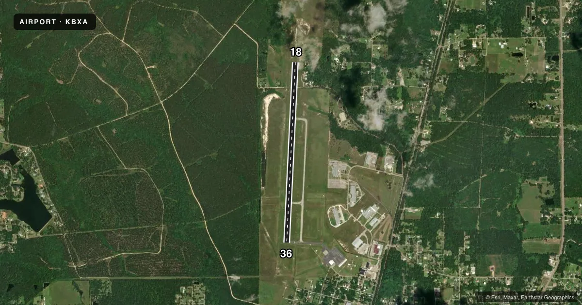
Runways & pattern
Full pagePattern entry · RWY 18
LEFT TRAFFICRunway end performance
| End | TORA | TODA | ASDA | LDA | VGSI | Approach lights | Obstruction |
|---|---|---|---|---|---|---|---|
| 18 | — | — | — | — | PAPI 2-box left(3°) | — | 87', trees, 1005' from thr, 350' R of cntrln, slope 9 |
| 36 | — | — | — | — | PAPI 2-box left(3°) | — | 79', trees, 2011' from thr, 283' R of cntrln, slope 22 |
Declared distances in feet. TORA = takeoff run available, TODA = takeoff distance, ASDA = accelerate-stop, LDA = landing distance.
Airport sketch
Runways drawn to scale from FAA survey coordinates, rendered over satellite imagery. Not for navigation.
Approaches & charts
ILS · 1
Services on the field
Fuel grades, oxygen, maintenance, ramp storage and lighting — as declared to the FAA by the airport operator.
Fuel & services
- Fuel
- 100LLA
- Oxygen (bottled)
- Not available
- Oxygen (bulk)
- Not available
- Airframe repair
- Major
- Power plant repair
- Major
Ramp & ground
- Transient storage
- Tie-down
- Hangar
- Landing fee
- No fee published
- Customs
- Not available
- Lighting schedule
- SEE RMK
- Beacon schedule
- SS-SR
- Beacon
- White / Green (civil land)(WG)
- Wind indicator
- Lighted
- Segmented circle
- No
Fuel & FBOs
Cheapest 100LL and Jet A on the field and nearby. Always confirm with the FBO before taxi.
Airport notes
Surface conditions, obstructions, local procedures, lighting outages and other notes published with each FAA cycle.
General notes
- FOR CD CTC HOUSTON ARTCC AT 281-230-5622.
- CTC AMGR FOR DSGND RAMP SPACE FOR PUB USE
Lighting notes
- DUSK-DAWN. REIL RWYS 18 & 36; MIRL RWY 18/36 PRESET LOW INTST DUSK-DAWN; TO INCR INTST - CTAF.
Fuel notes
- 100LLFUEL AVBL 24 HRS SELF SERVE WITH CREDIT CARD.
- ASINGLE POINT & OVERWING FUELING AVBL. 24 HRS SELF SERVICE WITH CREDIT CARD.
Approach & departure obstructions
- 18MARKINGS ARE FADED AND ARE COVERED WITH MOLD.
- 36MARKINGS ARE FADED AND COVERED WITH MOLD.
Other notes
- THIS AIRPORT HAS BEEN SURVEYED BY THE NATIONAL GEODETIC SURVEY.
- MANAGERAFTER HOURS 985-750-0485.
- 18/36RWY CONTAINS SVRL CRACKS WITH GRASS ERUPTION AND RAVELING.
VFR map & nearby airports
VFR sectional. Tap any ICAO chip to open that airport.
Key facts · KBXA
Answer card- ICAO
- KBXA
- Name
- GEORGE R CARR MEML AIR FLD
- Location
- BOGALUSA, LOUISIANA
- Elevation
- 119 ft MSL
- Traffic pattern altitude
- 1,119 ft MSL (1,000 AGL)
- Control tower
- Non-towered (use CTAF)
- Total runways
- 1
- Longest runway
- 18/36 · 5,002 ft
- Published ILS approaches
- 1
- Published frequencies
- 2
- Magnetic variation
- 0°
- Current flight rules
- VFR
- Current wind
- 000° at 0 kt
- Favored runway now
- –
George R Carr Meml Air Fld sits in Bogalusa, Louisiana. The field elevation is 119 ft MSL. It has one runway. Runway 18/36 is 5,002 ft long and asphalt. There is no control tower, so plan to use CTAF 122.8 for local traffic calls. The published pattern altitude is not listed. Use the standard 1,000 ft AGL for light piston operations unless the current Chart Supplement says otherwise.
An ILS approach is available to runway 18. That makes KBXA a useful stop when the weather starts to come down. The runway lighting is available from dusk to dawn. Runway end identifier lights are on both ends. Medium intensity runway lights are set to low intensity by default at night. Use CTAF to raise the intensity if needed.
Bogalusa Airport is the on-field FBO. It reports 100LL and Jet A self-serve with credit card. Fuel is available 24 hours. Contact the airport manager for designated public ramp space before arrival. For clearances, Houston Center is listed for delivery. This is a non-towered field with a single runway, so keep your radio work tight and watch for local traffic on 122.8.