METAR & TAF KASD
Current METAR
Observed 05:53Z
KASD 270553Z AUTO 00000KT 10SM +RA CLR 28/26 A2999 RMK AO2 SLP154 6//// T02830256 10328 20272 403440239 50006 PNO $
- Wind
- 000° @ 0 kt
- Visibility
- 10 SM
- Temp / Dew
- 28°C / 26°C
- Altimeter
- 29.99 inHg
- Clouds
- CLR
- Density alt
- 1,508 ft
- Ceiling
- Unlimited
- Rules
- VFR
Airport info & contacts
Manager on record, flight service, ARTCC, attendance schedule and pattern altitude — published by the FAA and refreshed every 28 days.
Location
- From city
- 4 NM NW
- VFR sectional
- NEW ORLEANS
- ARTCC
- ZHU · HOUSTON
- NOTAM facility
- ASD (NOTAM-D)
Airport manager
- Name
- JAMES FEULNER
- Phone
- 985-641-7590
- Address
- 62512 AIRPORT RD BLDG 12, SLIDELL LA 70460
Flight service · Hours
- FSS DRI
- DE RIDDER1-800-WX-BRIEF
- Attendance
- 0700-1600
Frequencies
Tap any row to copy the frequency to your clipboard.
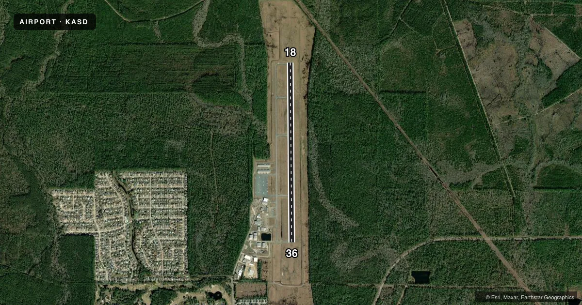
Runways & pattern
Full pagePattern entry · RWY 18
LEFT TRAFFICRunway end performance
| End | TORA | TODA | ASDA | LDA | VGSI | Approach lights | Obstruction |
|---|---|---|---|---|---|---|---|
| 18 | 5,001' | 5,001' | 5,001' | 4,057' | PAPI 2-box left(3°) | — | 61', trees, 1766' from thr, 184' R of cntrln, slope 25 |
| 36 | 5,001' | 5,001' | 5,001' | 5,001' | PAPI 2-box left(3°) | — | 85', trees, 3036' from thr, 105' R of cntrln, slope 33 |
Declared distances in feet. TORA = takeoff run available, TODA = takeoff distance, ASDA = accelerate-stop, LDA = landing distance.
Airport sketch
Runways drawn to scale from FAA survey coordinates, rendered over satellite imagery. Not for navigation.
Approaches & charts
Services on the field
Fuel grades, oxygen, maintenance, ramp storage and lighting — as declared to the FAA by the airport operator.
Fuel & services
- Fuel
- 100LLA+
- Oxygen (bottled)
- High pressure
- Oxygen (bulk)
- Not available
- Airframe repair
- Major
- Power plant repair
- Major
- Other services
- AGRI,CHTR,INSTR,PAJA,RNTL
Ramp & ground
- Transient storage
- Tie-down
- Landing fee
- No fee published
- Customs
- Not available
- Lighting schedule
- SEE RMK
- Beacon schedule
- SS-SR
- Beacon
- White / Green (civil land)(WG)
- Wind indicator
- Lighted
- Segmented circle
- No
Fuel & FBOs
Cheapest 100LL and Jet A on the field and nearby. Always confirm with the FBO before taxi.
Airport notes
Surface conditions, obstructions, local procedures, lighting outages and other notes published with each FAA cycle.
General notes
- WILDLIFE ON & INVOF RY.
- GCO AVBL ON FREQ 135.075 NEW ORLEANS APCH & DE RIDDER FSS.
- PAJA ON WKENDS.
- FOR CD CTC NEW ORLEANS APCH AT 504-471-4350.
- CTC APRT MGR FOR DSGND RAMP SPACE FOR PUB USE.
Lighting notes
- MIRL RY 18/36, REIL RYS 18 & 36 PRESET LOW INTST DUSK-DAWN; TO INCR INTST ACTVT - CTAF.
Fuel notes
- 100LL100LL AVBL 24 HRS WITH CREDIT CARD.
- A+FOR JET FUEL AFTER HOURS CALL 985 259-2460.
Approach & departure obstructions
- 18APCH SLOPE 41:1 TO DSPLCD THLD.
Other notes
- 1ARPT UNATNDD THANKSGIVING, CHRISTMAS, NEW YEARS DAY
- OWNERMAYOR'S PHONE.
VFR map & nearby airports
VFR sectional. Tap any ICAO chip to open that airport.
Key facts · KASD
Answer card- ICAO
- KASD
- Name
- SLIDELL
- Location
- SLIDELL, LOUISIANA
- Elevation
- 28.3 ft MSL
- Traffic pattern altitude
- 1,028.3 ft MSL (1,000 AGL)
- Control tower
- Non-towered (use CTAF)
- Total runways
- 1
- Longest runway
- 18/36 · 5,002 ft
- Published ILS approaches
- 0
- Published frequencies
- 4
- Magnetic variation
- 2°
- Current flight rules
- VFR
- Current wind
- 000° at 0 kt
- Favored runway now
- –
Slidell Airport is in Slidell, Louisiana. Field elevation is 28.3 ft MSL. The airport has one runway, 18/36, which is 5,002 ft long. It is an untowered field. Traffic pattern altitude is not published, so use standard 1,000 ft AGL for light piston operations unless the current Chart Supplement says otherwise. No ILS approaches are published here.
The on-field FBO is Slidell Municipal Airport. It carries AVGAS 100LL and JET A PRIST. 100LL is available 24 hours with credit card. For jet fuel after hours, call the number in the Chart Supplement remarks before you go. The field also notes wildlife on and near the runway. That is worth planning for on taxi, takeoff and landing.
There is medium intensity runway lighting on 18/36. The runway end identifier lights are preset low from dusk to dawn. Use the CTAF to increase intensity. New Orleans Approach handles approach and departure services. Clearance delivery is also handled through New Orleans Approach. The airport is unattended on Thanksgiving, Christmas and New Year's Day. If you need ramp space for public use, contact the airport manager before arrival. The field sits close to sea level, so density altitude is usually not the main issue. Local traffic, wildlife and lighting setup are the bigger items to brief.