METAR & TAF 66Y
66Y does not publish a METAR.
Showing the nearest reporting station: KHSA (STENNIS INTL) · 3.5 NM away. Conditions at 66Y may differ.
METAR · KHSA
Observed 00:50Z
KHSA 270050Z 25004KT 10SM CLR 29/23 A2995
- Wind
- 250° @ 4 kt
- Visibility
- 10 SM
- Temp / Dew
- 29°C / 23°C
- Altimeter
- 29.95 inHg
- Clouds
- CLR
- Density alt
- 1,660 ft
- Ceiling
- Unlimited
- Rules
- VFR
Airport info & contacts
Manager on record, flight service, ARTCC, attendance schedule and pattern altitude — published by the FAA and refreshed every 28 days.
Location
- From city
- 0 NM SW
- VFR sectional
- NEW ORLEANS
- ARTCC
- ZHU · HOUSTON
- NOTAM facility
- GWO (NOTAM-D)
Airport manager
- Name
- BRADLEY HOLLIDAY
- Phone
- 601-550-3059
- Address
- 1200 AIRPORT CIRCLE, DIAMONDHEAD MS 39525
Flight service · Hours
- FSS GWO
- GREENWOOD1-800-WX-BRIEF
- Attendance
- Unattended
Frequencies
Tap any row to copy the frequency to your clipboard.
Runways & pattern
Full pagePattern entry · RWY 18
LEFT TRAFFICRunway end performance
| End | TORA | TODA | ASDA | LDA | VGSI | Approach lights | Obstruction |
|---|---|---|---|---|---|---|---|
| 18 | — | — | — | — | — | — | 44', trees, 570' from thr, 100' R of cntrln, slope 8 |
Declared distances in feet. TORA = takeoff run available, TODA = takeoff distance, ASDA = accelerate-stop, LDA = landing distance.
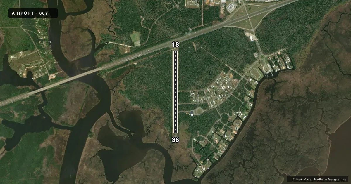
Airport sketch
Runways drawn to scale from FAA survey coordinates, rendered over satellite imagery. Not for navigation.
Approaches & charts
Services on the field
Fuel grades, oxygen, maintenance, ramp storage and lighting — as declared to the FAA by the airport operator.
Fuel & services
- Fuel
- 100LL
- Oxygen (bottled)
- Not available
- Oxygen (bulk)
- Not available
- Airframe repair
- Not available
- Power plant repair
- Not available
Ramp & ground
- Transient storage
- Tie-down
- Landing fee
- No fee published
- Lighting schedule
- SS-SR
- Wind indicator
- Yes
- Segmented circle
- No
Fuel & FBOs
Cheapest 100LL and Jet A on the field and nearby. Always confirm with the FBO before taxi.
Airport notes
Surface conditions, obstructions, local procedures, lighting outages and other notes published with each FAA cycle.
General notes
- WILDLIFE INVOF RWY.
- FOR CD CTC GULFPORT APCH AT 228-265-6151, WHEN APCH CLSD CTC HOUSTON ARTCC AT 281-230-5622.
Fuel notes
- 100LLFUEL AVBL 24 HRS WITH CREDIT CARD.
Approach & departure obstructions
- 18SAND PERIMETER ROAD 88 FT FM RWY END; +2 LGTD FENCE 123 FT FM RWY END.
- 18LIRL DTHR BAR & LGTS LCTD 423 FT S OF PAVEMENT END.
- 18APCH RATIO 20:1 TO DTHR.
Other notes
- VFR USE ONLY, ARPT TFC PATS ARE ESTABLISHED ON E SIDE OF RWY & RWY CNTRLN EXTENDED.
- OWNERDIAMONDHEAD COUNTRY CLUB & PROPERTY OWNERS ASSOCIATION.
VFR map & nearby airports
VFR sectional. Tap any ICAO chip to open that airport.
Key facts · 66Y
Answer card- ICAO
- 66Y
- Name
- DIAMONDHEAD
- Location
- DIAMONDHEAD, MISSISSIPPI
- Elevation
- 14 ft MSL
- Traffic pattern altitude
- 1,014 ft MSL (1,000 AGL)
- Control tower
- Non-towered (use CTAF)
- Total runways
- 1
- Longest runway
- 18/36 · 3,800 ft
- Published ILS approaches
- 0
- Published frequencies
- 2
- Magnetic variation
- 2°
- Current flight rules
- VFR
- Current wind
- 250° at 4 kt
- Favored runway now
- RWY 18
Diamondhead Airport sits in Diamondhead, Mississippi. Field elevation is 14 ft MSL. The airport has one runway. Runway 18/36 is 3,800 ft long. There is no control tower. CTAF and UNICOM are both 123.0. No ILS approaches are published here.
Pattern altitude is not published. Use the standard 1,000 ft AGL pattern unless the current Chart Supplement says otherwise. The field is VFR only. Published remarks say traffic patterns are on the east side of the runway and the runway centerline extended. That matters here because the airport also has a displaced threshold on runway 18. There is a sand perimeter road close to the runway end. A lighted fence is also near that end. Wildlife is noted in the runway area. Keep a sharp scan on taxi, takeoff and landing.
Diamondhead Airport is owned by the Diamondhead Country Club and Property Owners Association. On-field FBO service is provided by Diamondhead Airport. It carries AVGAS 100LL. Fuel is available 24 hours with credit card. For clearance delivery, contact Gulfport Approach. If approach is closed, contact Houston ARTCC. First-time arrivals should verify the current Chart Supplement before flying in. Brief the east-side pattern and the displaced threshold on 18.