METAR & TAF M24
M24 does not publish a METAR.
Showing the nearest reporting station: KHBG (HATTIESBURG BOBBY L CHAIN MUNI) · 25.8 NM away. Conditions at M24 may differ.
METAR · KHBG
Observed 02:53Z
KHBG 270253Z AUTO 00000KT 10SM CLR 30/23 A2996 RMK AO2 SLP141 T03000228 53004 $
- Wind
- 000° @ 0 kt
- Visibility
- 10 SM
- Temp / Dew
- 30°C / 23°C
- Altimeter
- 29.96 inHg
- Clouds
- CLR
- Density alt
- 2,089 ft
- Ceiling
- Unlimited
- Rules
- VFR
Airport info & contacts
Manager on record, flight service, ARTCC, attendance schedule and pattern altitude — published by the FAA and refreshed every 28 days.
Location
- From city
- 1 NM W
- VFR sectional
- NEW ORLEANS
- ARTCC
- ZHU · HOUSTON
- NOTAM facility
- GWO (NOTAM-D)
Airport manager
- Name
- DURON HATTEN
- Phone
- 601-928-7221
- Address
- PO BOX 219, WIGGINS MS 39577
Flight service · Hours
- FSS GWO
- GREENWOOD1-800-WX-BRIEF
- Attendance
- 0800-1700
Frequencies
Tap any row to copy the frequency to your clipboard.
Runways & pattern
Full pagePattern entry · RWY 17
LEFT TRAFFICRunway end performance
| End | TORA | TODA | ASDA | LDA | VGSI | Approach lights | Obstruction |
|---|---|---|---|---|---|---|---|
| 17 | — | — | — | — | PAPI 2-box left(3°) | — | 41', tree, 1200' from thr, 150' R of cntrln, slope 24 |
| 35 | — | — | — | — | PAPI 2-box left(3°) | — | 62', trees, 1440' from thr, 300' R of cntrln, slope 20 |
Declared distances in feet. TORA = takeoff run available, TODA = takeoff distance, ASDA = accelerate-stop, LDA = landing distance.
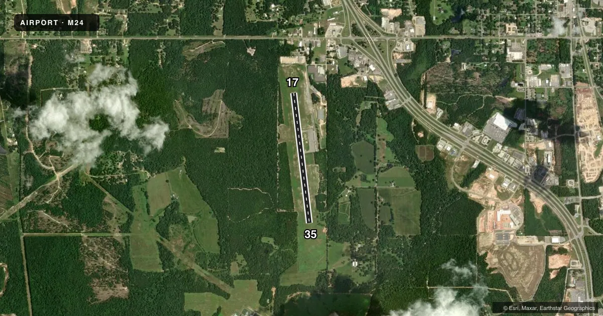
Airport sketch
Runways drawn to scale from FAA survey coordinates, rendered over satellite imagery. Not for navigation.
Approaches & charts
Services on the field
Fuel grades, oxygen, maintenance, ramp storage and lighting — as declared to the FAA by the airport operator.
Fuel & services
- Fuel
- 100LL
- Oxygen (bottled)
- Not available
- Oxygen (bulk)
- Not available
- Airframe repair
- Not available
- Other services
- AGRI
Ramp & ground
- Transient storage
- Tie-down
- Landing fee
- No fee published
- Customs
- Not available
- Lighting schedule
- SEE RMK
- Beacon schedule
- SS-SR
- Beacon
- White / Green (civil land)(WG)
- Wind indicator
- Lighted
- Segmented circle
- No
Fuel & FBOs
Cheapest 100LL and Jet A on the field and nearby. Always confirm with the FBO before taxi.
Airport notes
Surface conditions, obstructions, local procedures, lighting outages and other notes published with each FAA cycle.
General notes
- FOR CD CTC GULFPORT APCH AT 228-265-6151, WHEN APCH CLSD CTC HOUSTON ARTCC AT 281-230-5622.
Lighting notes
- ACTVT MIRL RWY 17/35 - CTAF. PAPI RWY 17 & 35 OPR CONSLY.
Fuel notes
- 100LLFUEL AVBL 24 HRS WITH CREDIT CARD.
Approach & departure obstructions
- 17APCH SLP 36:1 TO DTHR.
Other notes
- PILOTS MUST PRVD TIEDOWN ROPES.
VFR map & nearby airports
VFR sectional. Tap any ICAO chip to open that airport.
Key facts · M24
Answer card- ICAO
- M24
- Name
- DEAN GRIFFIN MEML
- Location
- WIGGINS, MISSISSIPPI
- Elevation
- 273 ft MSL
- Traffic pattern altitude
- 1,273 ft MSL (1,000 AGL)
- Control tower
- Non-towered (use CTAF)
- Total runways
- 1
- Longest runway
- 17/35 · 3,500 ft
- Published ILS approaches
- 0
- Published frequencies
- 4
- Magnetic variation
- 2°
- Current flight rules
- VFR
- Current wind
- 000° at 0 kt
- Favored runway now
- –
Dean Griffin Meml Airport (M24) sits in Wiggins, Mississippi. Field elevation is 273 ft MSL. The airport has one runway. Runway 17/35 is 3,500 ft of asphalt, so it is the runway to plan around here. There is no control tower. CTAF and UNICOM are both 122.8. Gulfport Approach handles clearance delivery and departure services when needed. The published frequencies are 127.5 and 254.25.
No ILS approaches are published. The pattern altitude is not published, so use the standard 1,000 ft AGL for light piston traffic unless the current Chart Supplement says otherwise. Runway lighting on 17/35 is medium intensity and is activated by the CTAF. The PAPI on both runway ends operates continuously. Fuel is available 24 hours with a credit card. Pilots must provide tiedown ropes.
There are no on-field FBOs listed. If you need ramp or service details, contact the airport operator or call the field directly before arrival. The published remarks also note a displaced threshold issue on runway 17. The approach slope to that displaced threshold is 36 to 1. That is worth checking before you plan a short final. This is a non-towered field near the Gulf Coast, so expect to work your own spacing and watch for local traffic. For current noise or operating restrictions, check the current FAA Chart Supplement before you go.