METAR & TAF M13
M13 does not publish a METAR.
Showing the nearest reporting station: KBXA (GEORGE R CARR MEML AIR FLD) · 18.7 NM away. Conditions at M13 may differ.
METAR · KBXA
Observed 02:55Z
KBXA 270255Z AUTO 26003KT 10SM CLR 29/24 A2997 RMK AO2 T02850235
- Wind
- 260° @ 3 kt
- Visibility
- 10 SM
- Temp / Dew
- 29°C / 24°C
- Altimeter
- 29.97 inHg
- Clouds
- CLR
- Density alt
- 2,013 ft
- Ceiling
- Unlimited
- Rules
- VFR
Airport info & contacts
Manager on record, flight service, ARTCC, attendance schedule and pattern altitude — published by the FAA and refreshed every 28 days.
Location
- From city
- 3 NM SE
- VFR sectional
- NEW ORLEANS
- ARTCC
- ZHU · HOUSTON
- NOTAM facility
- GWO (NOTAM-D)
Airport manager
- Name
- BRADLEY HOLLIDAY
- Phone
- 601-550-3059
- Address
- PO BOX 901, POPLARVILLE MS 39470
Flight service · Hours
- FSS GWO
- GREENWOOD1-800-WX-BRIEF
- Attendance
- Unattended
Frequencies
Tap any row to copy the frequency to your clipboard.
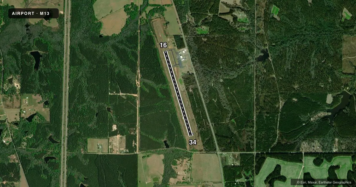
Runways & pattern
Full pagePattern entry · RWY 34
LEFT TRAFFICRunway end performance
| End | TORA | TODA | ASDA | LDA | VGSI | Approach lights | Obstruction |
|---|---|---|---|---|---|---|---|
| 16 | — | — | — | — | PAPI 2-box left(3°) | — | 55', trees, 1650' from thr, 0' R of cntrln, slope 26 |
| 34 | — | — | — | — | PAPI 2-box left(3°) | — | 29', trees, 800' from thr, 0' R of cntrln, slope 20 |
Declared distances in feet. TORA = takeoff run available, TODA = takeoff distance, ASDA = accelerate-stop, LDA = landing distance.
Airport sketch
Runways drawn to scale from FAA survey coordinates, rendered over satellite imagery. Not for navigation.
Approaches & charts
Services on the field
Fuel grades, oxygen, maintenance, ramp storage and lighting — as declared to the FAA by the airport operator.
Fuel & services
- Fuel
- 100LL
- Oxygen (bottled)
- Not available
- Oxygen (bulk)
- Not available
- Airframe repair
- Major
- Power plant repair
- Major
Ramp & ground
- Transient storage
- Tie-down
- Customs
- Not available
- Lighting schedule
- SEE RMK
- Beacon schedule
- SS-SR
- Beacon
- White / Green (civil land)(WG)
- Wind indicator
- Lighted
- Segmented circle
- Yes
Fuel & FBOs
Cheapest 100LL and Jet A on the field and nearby. Always confirm with the FBO before taxi.
Airport notes
Surface conditions, obstructions, local procedures, lighting outages and other notes published with each FAA cycle.
General notes
- ULTRALIGHT ACT ON & INVOF ARPT.
- FOR CD CTC GULFPORT APCH AT 228-265-6151, WHEN APCH CLSD CTC HOUSTON ARTCC AT 281-230-5622.
Lighting notes
- MIRL RWY 16/34 OPER DUSK - 2100. AFT 2100 ACTVT - CTAF. PAPI RWY 16 & 34 OPR CONSLY.
Fuel notes
- 100LLFUEL 24 HR SELF SVC WITH CREDIT CARD.
Approach & departure obstructions
- 16335 FT AGL ANT TWR ON L DOWNWIND PAT.
Other notes
- PILOTS MUST PRVD TIEDOWN ROPES.
VFR map & nearby airports
VFR sectional. Tap any ICAO chip to open that airport.
Key facts · M13
Answer card- ICAO
- M13
- Name
- POPLARVILLE/PEARL RIVER COUNTY
- Location
- POPLARVILLE, MISSISSIPPI
- Elevation
- 318.9 ft MSL
- Traffic pattern altitude
- 1,318.9 ft MSL (1,000 AGL)
- Control tower
- Non-towered (use CTAF)
- Total runways
- 1
- Longest runway
- 16/34 · 4,000 ft
- Published ILS approaches
- 0
- Published frequencies
- 3
- Magnetic variation
- 2°
- Current flight rules
- VFR
- Current wind
- 260° at 3 kt
- Favored runway now
- RWY 34
Poplarville/Pearl River County Airport is in Poplarville, Mississippi. Field elevation is 318.9 ft MSL. The airport has one runway. Runway 16/34 is 4,000 ft asphalt, which is the longest runway on the field. There is no control tower. No ILS approaches are published, so check current approach options before you go.
Pattern altitude is not published. Use 1,000 ft AGL for light piston operations unless the current Chart Supplement or local guidance says otherwise. The published remarks matter here. There is a 335 ft AGL antenna tower on the left downwind side for runway 16. Ultralight activity also occurs on and near the airport. Fuel is available 24 hours self-service with a credit card.
The on-field FBO is Poplarville-Pearl River County Airport. It carries AVGAS 100LL. Pilots must bring tiedown ropes. Medium intensity runway lights for 16/34 operate from dusk to 2100. After 2100, activate them on CTAF. PAPI for both runway ends operates continuously. Clearance delivery is handled through Gulfport Approach when it is open. If approach is closed, contact Houston ARTCC. This is an uncontrolled field, so plan for self-announce traffic and watch the pattern closely.