METAR & TAF 2R7
2R7 does not publish a METAR.
Showing the nearest reporting station: KBXA (GEORGE R CARR MEML AIR FLD) · 12.8 NM away. Conditions at 2R7 may differ.
METAR · KBXA
Observed 06:15Z
KBXA 270615Z AUTO 00000KT 10SM CLR 26/24 A3000 RMK AO2 T02620235
- Wind
- 000° @ 0 kt
- Visibility
- 10 SM
- Temp / Dew
- 26°C / 24°C
- Altimeter
- 30.00 inHg
- Clouds
- CLR
- Density alt
- 1,438 ft
- Ceiling
- Unlimited
- Rules
- VFR
Airport info & contacts
Manager on record, flight service, ARTCC, attendance schedule and pattern altitude — published by the FAA and refreshed every 28 days.
Location
- From city
- 3 NM SE
- VFR sectional
- NEW ORLEANS
- ARTCC
- ZHU · HOUSTON
- NOTAM facility
- DRI (NOTAM-D)
Airport manager
- Name
- MARTY ROBERTS
- Phone
- (225) 333-1579
- Address
- 26469 OLD LAKE ROAD, MOUNT HERMON LA 70450
Flight service · Hours
- FSS DRI
- DE RIDDER1-800-WX-BRIEF
- Attendance
- Unattended
Frequencies
Tap any row to copy the frequency to your clipboard.
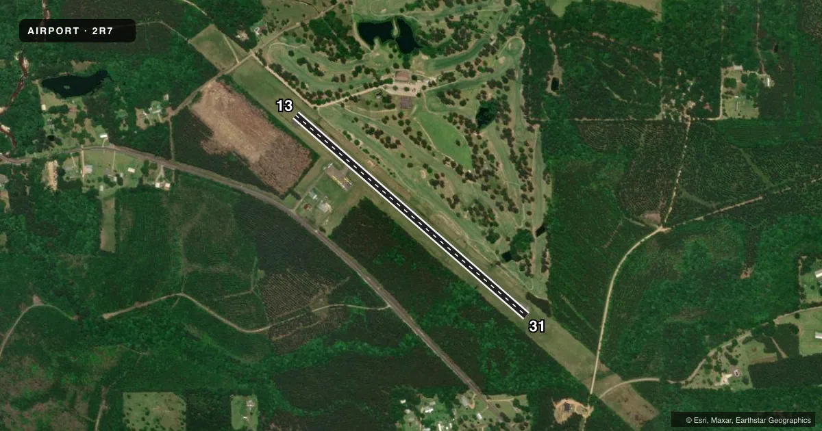
Runways & pattern
Full pagePattern entry · RWY 13
LEFT TRAFFICRunway end performance
| End | TORA | TODA | ASDA | LDA | VGSI | Approach lights | Obstruction |
|---|---|---|---|---|---|---|---|
| 13 | — | — | — | — | PAPI 2-box left(3°) | — | 76', trees, 1069' from thr, 185' R of cntrln, slope 11 |
| 31 | — | — | — | — | PAPI 2-box left(3°) | — | 73', trees, 901' from thr, 171' R of cntrln, slope 9 |
Declared distances in feet. TORA = takeoff run available, TODA = takeoff distance, ASDA = accelerate-stop, LDA = landing distance.
Airport sketch
Runways drawn to scale from FAA survey coordinates, rendered over satellite imagery. Not for navigation.
Approaches & charts
Services on the field
Fuel grades, oxygen, maintenance, ramp storage and lighting — as declared to the FAA by the airport operator.
Fuel & services
- Fuel
- Not available
- Oxygen (bottled)
- Not available
- Oxygen (bulk)
- Not available
Ramp & ground
- Transient storage
- Tie-down
- Hangar
- Landing fee
- No fee published
- Lighting schedule
- SEE RMK
- Beacon schedule
- SS-SR
- Beacon
- White / Green (civil land)(WG)
- Wind indicator
- Lighted
- Segmented circle
- No
Fuel & FBOs
Cheapest 100LL and Jet A on the field and nearby. Always confirm with the FBO before taxi.
Airport notes
Surface conditions, obstructions, local procedures, lighting outages and other notes published with each FAA cycle.
General notes
- GOLF COURSE .25 MILES NORTH OF AIRPORT.
- FOR CD CTC HOUSTON ARTCC AT 281-230-5622.
- ARPT LGTG OTS. VFR ONLY
- CTC APRT MGR FOR DSGND RAMP SPACE FOR PUB USE.
Lighting notes
- MIRL RWY 13/31 PRESET LOW INTST; TO INCR INTST ACTVT - CTAF.
Approach & departure obstructions
- 13RWY 13 REILS OTS.
- 31RWY 31 REILS OTS.
- 13RWY MARKINGS CHIPPED AND FADED
- 31RUNWAY MARKINGS CHIPPED AND FADED
- 13RY 13 PAPI OTS INDEFLY.
- 31RY 31 PAPI OTS INDEFLY.
VFR map & nearby airports
VFR sectional. Tap any ICAO chip to open that airport.
Key facts · 2R7
Answer card- ICAO
- 2R7
- Name
- FRANKLINTON
- Location
- FRANKLINTON, LOUISIANA
- Elevation
- 175 ft MSL
- Traffic pattern altitude
- 1,175 ft MSL (1,000 AGL)
- Control tower
- Non-towered (use CTAF)
- Total runways
- 1
- Longest runway
- 13/31 · 3,000 ft
- Published ILS approaches
- 0
- Published frequencies
- 1
- Magnetic variation
- 3°
- Current flight rules
- VFR
- Current wind
- 000° at 0 kt
- Favored runway now
- –
Franklinton Airport (2R7) sits in Franklinton, Louisiana. Field elevation is 175 ft MSL. The airport has one runway, 13/31, which is 3,000 ft long and asphalt. There is no control tower. CTAF is 122.9. No ILS approaches are published here.
Pattern altitude is not published. Use the standard 1,000 ft AGL for light piston operations unless the current Chart Supplement says otherwise. Runway headings are 131° and 311° magnetic. Published remarks show the runway lighting is set to low intensity by default. You can increase it by keying the CTAF. The airport lighting is out of service, so this is VFR only. Runway 13 REILs and PAPI are out of service. Runway 31 REILs and PAPI are also out of service. Markings on both ends are chipped and faded.
There are no on-field FBOs listed in the facts. Contact the airport manager for designated ramp space for public use before you go. For clearance delivery, Houston ARTCC is listed in the remarks. A golf course sits about 0.25 miles north of the airport, so keep that in mind on departure and arrival. If you need current operating details, check the current FAA Chart Supplement or call the airport operator directly.