METAR & TAF L31
L31 does not publish a METAR.
Showing the nearest reporting station: KASD (SLIDELL) · 10.5 NM away. Conditions at L31 may differ.
METAR · KASD
Observed 01:53Z
KASD 270153Z AUTO 00000KT 10SM -RA CLR 28/24 A2995 RMK AO2 SLP142 P0000 T02780244 $
- Wind
- 000° @ 0 kt
- Visibility
- 10 SM
- Temp / Dew
- 28°C / 24°C
- Altimeter
- 29.95 inHg
- Clouds
- CLR
- Density alt
- 1,570 ft
- Ceiling
- Unlimited
- Rules
- VFR
Airport info & contacts
Manager on record, flight service, ARTCC, attendance schedule and pattern altitude — published by the FAA and refreshed every 28 days.
Location
- From city
- 6 NM SE
- VFR sectional
- NEW ORLEANS
- ARTCC
- ZHU · HOUSTON
- NOTAM facility
- DRI (NOTAM-D)
Airport manager
- Name
- JIM FORD
- Phone
- (985) 898-2792
- Address
- PO BOX 628, COVINGTON LA 70434
Flight service · Hours
- FSS DRI
- DE RIDDER1-800-WX-BRIEF
- Attendance
- MON-FRI · 0800-1500
Frequencies
Tap any row to copy the frequency to your clipboard.
Runways & pattern
Full pagePattern entry · RWY 18
LEFT TRAFFICRunway end performance
| End | TORA | TODA | ASDA | LDA | VGSI | Approach lights | Obstruction |
|---|---|---|---|---|---|---|---|
| 18 | — | — | — | — | — | — | 72', trees, 1891' from thr, 0' R of cntrln, slope 23 |
| 36 | — | — | — | — | — | — | 88', trees, 905' from thr, 180' R of cntrln, slope 8 |
Declared distances in feet. TORA = takeoff run available, TODA = takeoff distance, ASDA = accelerate-stop, LDA = landing distance.
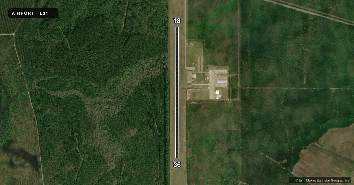
Airport sketch
Runways drawn to scale from FAA survey coordinates, rendered over satellite imagery. Not for navigation.
Approaches & charts
Services on the field
Fuel grades, oxygen, maintenance, ramp storage and lighting — as declared to the FAA by the airport operator.
Fuel & services
- Fuel
- 100LL
- Airframe repair
- Minor
- Power plant repair
- Minor
- Other services
- CHTR,INSTR,PAJA,RNTL,TOW
Ramp & ground
- Transient storage
- Tie-down
- Hangar
- Landing fee
- No fee published
- Customs
- Not available
- Lighting schedule
- SEE RMK
- Beacon schedule
- SS-SR
- Beacon
- White / Green (civil land)(WG)
- Wind indicator
- Lighted
- Segmented circle
- No
Fuel & FBOs
Cheapest 100LL and Jet A on the field and nearby. Always confirm with the FBO before taxi.
Airport notes
Surface conditions, obstructions, local procedures, lighting outages and other notes published with each FAA cycle.
General notes
- FOR CD CTC NEW ORLEANS APCH AT 504-471-4350.
- PAJA AND SKYDIVING ACT ON WKENDS.
- CTC APRT MGR FOR DSGND RAMP SPACE FOR PUB USE.
Lighting notes
- DUSK-DAWN. MIRL RY 18/36 PRESET MED INTST.
Fuel notes
- 100LLSELF SERVICE FUEL AVBL 24 HRS WITH CREDIT CARD.
Other notes
- OVERNIGHT RAMP FEE
VFR map & nearby airports
VFR sectional. Tap any ICAO chip to open that airport.
Key facts · L31
Answer card- ICAO
- L31
- Name
- ST TAMMANY RGNL
- Location
- COVINGTON, LOUISIANA
- Elevation
- 37.7 ft MSL
- Traffic pattern altitude
- 1,037.7 ft MSL (1,000 AGL)
- Control tower
- Non-towered (use CTAF)
- Total runways
- 1
- Longest runway
- 18/36 · 3,004 ft
- Published ILS approaches
- 0
- Published frequencies
- 4
- Magnetic variation
- 2°
- Current flight rules
- VFR
- Current wind
- 000° at 0 kt
- Favored runway now
- –
ST TAMMANY RGNL sits in Covington, Louisiana. Field elevation is 37.7 ft MSL. The airport has one runway. Runway 18/36 is 3,004 ft of asphalt. There is no control tower. Clearance delivery goes through New Orleans Approach. The published approach frequencies are 133.15 and 290.3. No ILS approaches are published.
Pattern altitude is not published. Use the standard 1,000 ft AGL for light piston operations unless the current Chart Supplement says otherwise. The field is close to sea level, so density altitude is usually not the main issue. Traffic flow can still get busy on weekends because parachute jumping and skydiving activity occurs then.
St. Tammany Parish Government is on the field. It carries 100LL. Self-service 100LL is available 24 hours with a credit card. Runway 18/36 medium intensity lights are preset from dusk to dawn. There is also an overnight ramp fee. Public ramp space is assigned by the airport manager, so call ahead if you need a spot.