METAR & TAF KNEW
Current METAR
Observed 06:53Z
KNEW 270653Z AUTO 25012KT 10SM CLR 29/26 A2999 RMK AO1 SLP150 T02890256
- Wind
- 250° @ 12 kt
- Visibility
- 10 SM
- Temp / Dew
- 29°C / 26°C
- Altimeter
- 29.99 inHg
- Clouds
- CLR
- Density alt
- 1,602 ft
- Ceiling
- Unlimited
- Rules
- VFR
Airport info & contacts
Manager on record, flight service, ARTCC, attendance schedule and pattern altitude — published by the FAA and refreshed every 28 days.
Location
- From city
- 4 NM NE
- VFR sectional
- NEW ORLEANS
- ARTCC
- ZHU · HOUSTON
- NOTAM facility
- NEW (NOTAM-D)
Airport manager
- Name
- BRUCE MARTIN
- Phone
- 504-243-4010
- Address
- 6001 STARS & STRIPES BLVD, SUITE 204, NEW ORLEANS LA 70126
Flight service · Hours
- FSS DRI
- DE RIDDER1-800-WX-BRIEF
- Attendance
- ALL
Frequencies
Tap any row to copy the frequency to your clipboard.
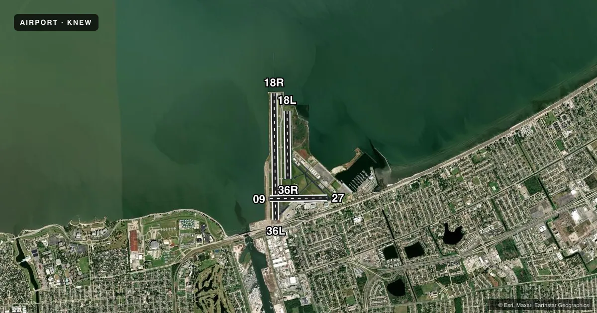
Runways & pattern
Full pagePattern entry · RWY 27
RIGHT TRAFFIC| Runway | Heading (°M) | Length | Surface | Traffic |
|---|---|---|---|---|
| 18R/36L | 177° / 357° | 6,879 ft | ASPH | 18R R |
| 18L/36R | 177° / 357° | 3,697 ft | ASPH | 36R R |
| 09/27Favored | 87° / 267° | 3,114 ft | ASPH | 27 R |
Runway end performance
| End | TORA | TODA | ASDA | LDA | VGSI | Approach lights | Obstruction |
|---|---|---|---|---|---|---|---|
| 18R | 6,880' | 6,880' | 6,035' | 5,510' | PAPI 4-box left(3°) | MALSR | 6', other, 300' from thr, 0' R of cntrln, slope 16 |
| 36L | 6,880' | 6,880' | 5,955' | 5,135' | PAPI 4-box left(3°) | — | 7', berm, 200' from thr, 0' R of cntrln, slope 0 |
| 18L | 3,697' | 3,697' | 3,697' | 3,697' | — | — | — |
| 36R | 3,697' | 3,697' | 3,697' | 3,697' | PAPI 4-box left(3°) | — | 54', bldg, 2035' from thr, 35' R of cntrln, slope 33 |
| 09 | 3,113' | 3,113' | 3,113' | 3,113' | PAPI 4-box left(3°) | — | 4', berm, 267' from thr, 0' R of cntrln, slope 16 |
| 27 | 3,113' | 3,113' | 3,113' | 3,113' | PAPI 4-box right(3.2°) | — | 14', road, 543' from thr, 161' R of cntrln, slope 24 |
Declared distances in feet. TORA = takeoff run available, TODA = takeoff distance, ASDA = accelerate-stop, LDA = landing distance.
Airport sketch
Runways drawn to scale from FAA survey coordinates, rendered over satellite imagery. Not for navigation.
Approaches & charts
ILS · 1
Services on the field
Fuel grades, oxygen, maintenance, ramp storage and lighting — as declared to the FAA by the airport operator.
Fuel & services
- Fuel
- 100LLA
- Oxygen (bottled)
- High pressure
- Oxygen (bulk)
- High pressure
- Airframe repair
- Major
- Power plant repair
- Major
- Other services
- AMB,AVNCS,CHTR,INSTR,RNTL,SALES
Ramp & ground
- Transient storage
- Tie-down
- Hangar
- Landing fee
- No fee published
- Customs
- Not available
- Lighting schedule
- SEE RMK
- Beacon schedule
- SEE RMK
- Beacon
- White / Green (civil land)(WG)
- Wind indicator
- Lighted
- Segmented circle
- Yes
Fuel & FBOs
Cheapest 100LL and Jet A on the field and nearby. Always confirm with the FBO before taxi.
Airport notes
Surface conditions, obstructions, local procedures, lighting outages and other notes published with each FAA cycle.
General notes
- PPR REQUIRED FOR ACFT TRNSPG ANY ITEMS LISTED IN PART 175 TITLE 49. CONTACT 504-606-9264
- BIRDS ON & INVOF ARPT.
- BOATS AS HIGH AS 80 FT PASS WI 400 FT OF RWY 09 THLD.
- ARFF CPBLTY EQUIVALENT TO INDEX B.
- FUEL NOT AVAILABLE WITHIN 100' OF TERMINAL BUILDING
- TWY A UNEVEN PAVEMENT.
- FOR ASSTNC AFTER 2100 LOCAL CTC AMGR 504-874-0459
- FOR FICONS AFTER HRS CALL ARFF 504-606-9264.
- BOAT MASTS UP TO 80 FT WI 0.5NM OF AER RWY 27.
- ARPT WINDCONE FOR BALL PARK RAMP LGTS OTS PERMLY.
- CAUTION TWY F BTN TRML RAMP AND FLT LN FST RAMP IREG SFC.
- FOR CD WHEN ATCT IS CLSD CTC MSY APCH AT 504-471-4350 OR 127.4
- CTC ARPT MGR FOR DSGND RAMP SPACE FOR PUB USE AT ARPT
Lighting notes
- FOR ARPT BCN CTC ATCT.
- WHEN TWR CLSD ACTVT MALSR RWY 18R; MIRL RWY 18R/36L; TWY B, C, D, E, F, H, EAST HNGRLN - PRESET LOW INTST. ACTVT 5 CLICKS FOR MED AND 7 CLICKS FOR HIGH - CTAF.
Approach & departure obstructions
- 36L+7 FT WALL 150 FT FM RY END.
- 36RRWY 36R PAPI UNUSBL BTN 2100 AND 0700 LOCAL
- 18RAPCH RATIO 50:1 FM DSPLCD THR.
- 36LAPCH RATIO 32:1 AT DSPLCD THR; +77' SILO 2500'; 580' R.
- 18RPIER.
Other notes
- OVERNIGHT PARKING ON TERMINAL RAMP MUST BE COORDINATED WITH FBO
- 18R/36LFEW LOW SPOTS NEAR INTERSECTION OF RY 09/27-HOLDING WATER.
VFR map & nearby airports
VFR sectional. Tap any ICAO chip to open that airport.
Key facts · KNEW
Answer card- ICAO
- KNEW
- Name
- LAKEFRONT
- Location
- NEW ORLEANS, LOUISIANA
- Elevation
- 7.3 ft MSL
- Traffic pattern altitude
- 1,007.3 ft MSL (1,000 AGL)
- Control tower
- Towered · 0700-2100
- Total runways
- 3
- Longest runway
- 18R/36L · 6,879 ft
- Published ILS approaches
- 1
- Published frequencies
- 11
- Magnetic variation
- 2°
- Current flight rules
- VFR
- Current wind
- 250° at 12 kt
- Favored runway now
- RWY 27
Lakefront Airport sits in New Orleans, Louisiana. Field elevation is 7.3 ft MSL. The airport has three asphalt runways. The longest is 6,879 ft on 18R/36L. The tower is open 0700-2100. One ILS is published for runway 18R. Pattern altitude is not published, so use 1,000 ft AGL for light piston unless ATC gives you something different.
This is a low-lying coastal field, so watch the weather and the water. Boats as high as 80 feet can pass close to the runway 09 threshold. There are also low spots that can hold water near the intersection of runway 09/27 with runway 18R/36L. Taxiway F has an irregular surface between the terminal ramp and the flight line fast ramp. When the tower is closed, clearance delivery goes through MSY Approach on 127.4 or by phone. The airport also uses CTAF 118.95.
On field FBOs are Signature Aviation, Flightline First and Skyborne. They carry AVGAS 100LL. They also carry JET A. Flightline First and Skyborne also carry JET A PRIST. Overnight parking on the terminal ramp must be coordinated with the FBO. For public ramp space, contact the airport manager before you go.