METAR & TAF KGAO
Current METAR
Observed 11:35Z
KGAO 271135Z AUTO 29003KT 10SM SCT022 26/24 A2999 RMK AO2 T02610240
- Wind
- 290° @ 3 kt
- Visibility
- 10 SM
- Temp / Dew
- 26°C / 24°C
- Altimeter
- 29.99 inHg
- Clouds
- SCT
- Density alt
- 1,233 ft
- Ceiling
- Unlimited
- Rules
- VFR
Airport info & contacts
Manager on record, flight service, ARTCC, attendance schedule and pattern altitude — published by the FAA and refreshed every 28 days.
Location
- From city
- 1 NM E
- VFR sectional
- NEW ORLEANS
- ARTCC
- ZHU · HOUSTON
- NOTAM facility
- DRI (NOTAM-D)
Airport manager
- Name
- GWAYNE GAUTREAUX
- Phone
- 985-291-0818
- Address
- 16829 EAST MAIN, CUTOFF LA 70345
Flight service · Hours
- FSS DRI
- DE RIDDER1-800-WX-BRIEF
- Attendance
- ALL
Frequencies
Tap any row to copy the frequency to your clipboard.
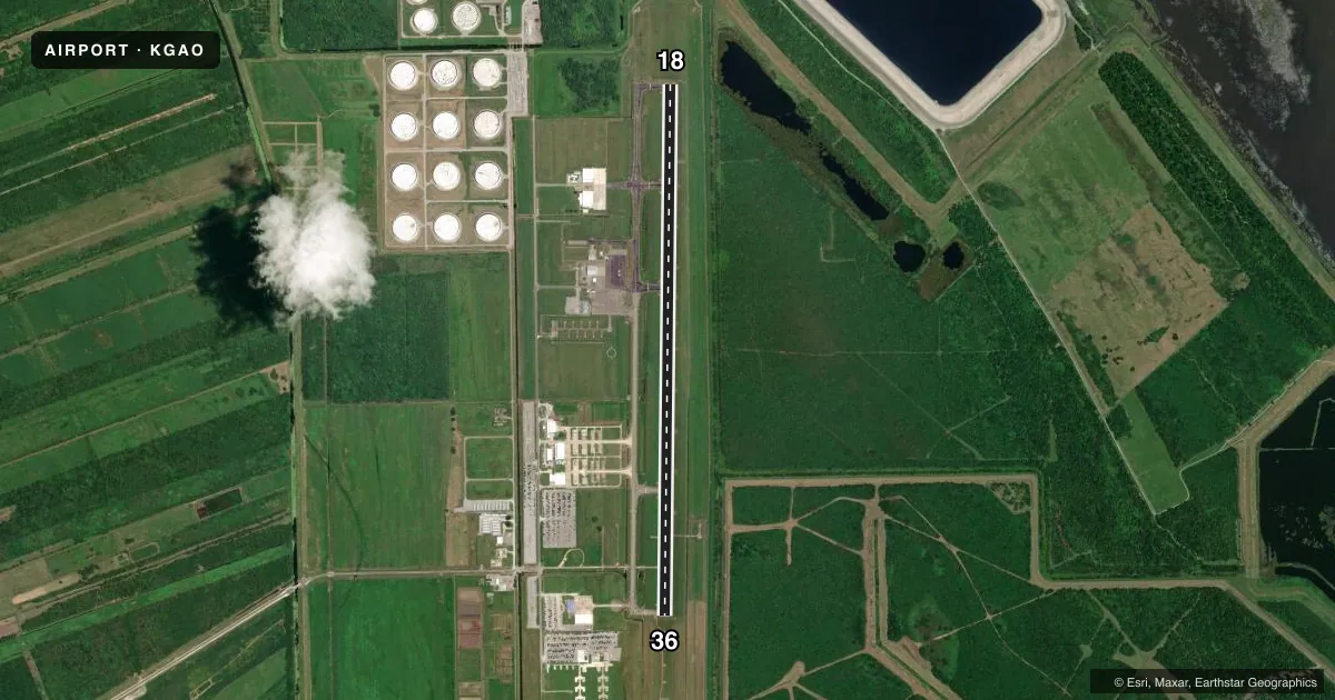
Runways & pattern
Full pagePattern entry · RWY 36
LEFT TRAFFICRunway end performance
| End | TORA | TODA | ASDA | LDA | VGSI | Approach lights | Obstruction |
|---|---|---|---|---|---|---|---|
| 18 | — | — | — | — | PAPI 4-box left(3°) | — | 70', trees, 2306' from thr, 540' R of cntrln, slope 30 |
| 36 | — | — | — | — | PAPI 4-box left(3°) | SSALR | — |
Declared distances in feet. TORA = takeoff run available, TODA = takeoff distance, ASDA = accelerate-stop, LDA = landing distance.
Airport sketch
Runways drawn to scale from FAA survey coordinates, rendered over satellite imagery. Not for navigation.
Approaches & charts
ILS · 1
Services on the field
Fuel grades, oxygen, maintenance, ramp storage and lighting — as declared to the FAA by the airport operator.
Fuel & services
- Fuel
- 100LLA1+
- Oxygen (bottled)
- Not available
- Oxygen (bulk)
- Not available
- Airframe repair
- Not available
- Power plant repair
- Not available
- Other services
- AVNCS
Ramp & ground
- Transient storage
- Tie-down
- Hangar
- Lighting schedule
- SEE RMK
- Beacon schedule
- SS-SR
- Beacon
- White / Green (civil land)(WG)
- Wind indicator
- Lighted
- Segmented circle
- Yes
Fuel & FBOs
Cheapest 100LL and Jet A on the field and nearby. Always confirm with the FBO before taxi.
Airport notes
Surface conditions, obstructions, local procedures, lighting outages and other notes published with each FAA cycle.
General notes
- ALL SFC WORK IN PROG MOWING. BIRD ACTY INVOF RWY 18/36.
- FOR CD CTC NEW ORLEANS APCH AT 504-471-4350 OR 120.85.
- CTC APRT MGR FOR DSGND RAMP SPACE FOR PUB USE.
Lighting notes
- SSALR RWY 36; REIL RWY 18 AND MIRL RWY 18 & 36 PRESET LOW INTST DUSK-DAWN; PAPI RWY 18 & 36 OPR CONSLY; TO INCR INTST ACTVT - CTAF.
Fuel notes
- 100LLFUEL AVBL 24/7 WITH CC.
Other notes
- MANAGERAFT HRS PHONE 985-475-6701.
VFR map & nearby airports
VFR sectional. Tap any ICAO chip to open that airport.
Key facts · KGAO
Answer card- ICAO
- KGAO
- Name
- SOUTH LAFOURCHE LEONARD MILLER JR
- Location
- GALLIANO, LOUISIANA
- Elevation
- 0 ft MSL
- Traffic pattern altitude
- 1,000 ft MSL (1,000 AGL)
- Control tower
- Non-towered (use CTAF)
- Total runways
- 1
- Longest runway
- 18/36 · 6,500 ft
- Published ILS approaches
- 1
- Published frequencies
- 5
- Magnetic variation
- 2°
- Current flight rules
- VFR
- Current wind
- 290° at 3 kt
- Favored runway now
- RWY 36
South Lafourche Leonard Miller Jr is in Galliano, Louisiana. The field elevation is 0 ft MSL. It has one runway, 18/36, which is 6,500 ft long. There is no control tower. Pattern altitude is not published, so use the standard 1,000 ft AGL for light piston operations unless the current Chart Supplement says otherwise.
The airport has one ILS approach to runway 36. CTAF and UNICOM are both 123.0. New Orleans Approach handles clearance delivery and approach or departure on 120.85, with 256.9 also listed for approach or departure. The on-field FBO is South Lafourche Airport. It carries 100LL and JET-A. Fuel is available 24 hours a day with a credit card.
This is a low-elevation coastal field, so watch the weather and the wind. Published remarks also note bird activity near runway 18/36. Surface work is in progress, including mowing. Runway 36 has steady-burning lighting. Runway 18 has runway end identifier lights. Medium intensity runway lights are set to low intensity from dusk to dawn. PAPI is available on both runway ends and can be brightened by keying the CTAF. Contact the airport manager for designated ramp space before you plan to park.