METAR & TAF KHUM
Current METAR
Observed 23:47Z
KHUM 262347Z 23008KT 7SM SCT034 32/24 A2998
- Wind
- 230° @ 8 kt
- Visibility
- 7 SM
- Temp / Dew
- 32°C / 24°C
- Altimeter
- 29.98 inHg
- Clouds
- SCT
- Density alt
- 1,976 ft
- Ceiling
- Unlimited
- Rules
- VFR
Airport info & contacts
Manager on record, flight service, ARTCC, attendance schedule and pattern altitude — published by the FAA and refreshed every 28 days.
Location
- From city
- 3 NM SE
- VFR sectional
- NEW ORLEANS
- ARTCC
- ZHU · HOUSTON
- NOTAM facility
- HUM (NOTAM-D)
Airport manager
- Name
- ED JARVIS
- Phone
- 985-872-4646
- Address
- 10264 EAST MAIN ST, HOUMA LA 70363
Flight service · Hours
- FSS DRI
- DE RIDDER1-800-WX-BRIEF
- Attendance
- 0600-1900
Frequencies
Tap any row to copy the frequency to your clipboard.
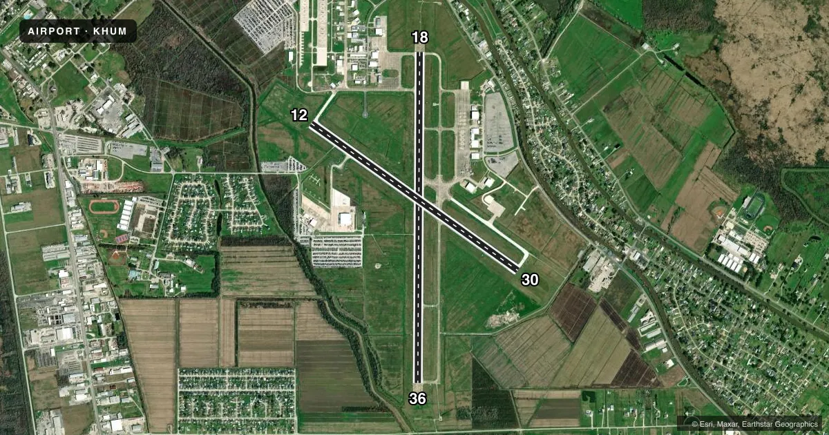
Runways & pattern
Full pagePattern entry · RWY 18
LEFT TRAFFIC| Runway | Heading (°M) | Length | Surface | Traffic |
|---|---|---|---|---|
| 18/36Favored | 179° / 359° | 6,509 ft | CONC | Standard L |
| 12/30 | 124° / 304° | 4,999 ft | CONC | Standard L |
Runway end performance
| End | TORA | TODA | ASDA | LDA | VGSI | Approach lights | Obstruction |
|---|---|---|---|---|---|---|---|
| 18 | 6,508' | 6,508' | 6,143' | 6,143' | PAPI 2-box left(3°) | MALSR | 77', trees, 3164' from thr, 0' R of cntrln, slope 38 |
| 36 | 6,508' | 6,508' | 6,508' | 6,508' | PAPI 2-box left(3°) | — | 54', trees, 2114' from thr, 0' R of cntrln, slope 35 |
| 12 | 4,999' | 4,999' | 4,843' | 4,843' | PAPI 2-box left(3°) | — | 51', trees, 1353' from thr, 178' R of cntrln, slope 22 |
| 30 | 4,999' | 4,999' | 4,999' | 4,999' | PAPI 2-box left(3°) | — | — |
Declared distances in feet. TORA = takeoff run available, TODA = takeoff distance, ASDA = accelerate-stop, LDA = landing distance.
Airport sketch
Runways drawn to scale from FAA survey coordinates, rendered over satellite imagery. Not for navigation.
Approaches & charts
ILS · 1
Services on the field
Fuel grades, oxygen, maintenance, ramp storage and lighting — as declared to the FAA by the airport operator.
Fuel & services
- Fuel
- 100LLA
- Oxygen (bottled)
- HIGH/LOW
- Oxygen (bulk)
- HIGH/LOW
- Airframe repair
- Major
- Power plant repair
- Major
- Other services
- AFRT,AMB,AVNCS,CHTR,INSTR
Ramp & ground
- Transient storage
- Tie-down
- Hangar
- Landing fee
- No fee published
- Customs
- Not available
- Lighting schedule
- SEE RMK
- Beacon schedule
- SS-SR
- Beacon
- White / Green (civil land)(WG)
- Wind indicator
- Lighted
- Segmented circle
- No
Fuel & FBOs
Cheapest 100LL and Jet A on the field and nearby. Always confirm with the FBO before taxi.
Airport notes
Surface conditions, obstructions, local procedures, lighting outages and other notes published with each FAA cycle.
General notes
- BIRDS ON & INVOF ARPT. NUMEROUS BIRDS 500 FT AGL & BLO 2.8 NM SSW AER 36; AVOIDANCE ADVISED.
- RY 12/30 SFC SKID RESISTANCE FAIR WHEN WET
- EXTENSIVE HELICOPTER OPNS SOUTH THRU WEST OF ARPT.
- FOR CD WHEN ATCT IS CLSD CTC MSY APCH AT 504-471-4350 OR 118.9.
- CTC APRT MGR FOR DSGND RAMP SPACE FOR PUB USE.
Lighting notes
- ACTVT MALSR RWY 18; REIL RWY 12, 30 & 36; MIRL RWY 12/30 & 18/36 - CTAF.
Fuel notes
- 100LLFUEL AVBL 24 HRS WITH CREDIT CARD.
Other notes
- OWNERCITY OF HOUMA AND TERREBONNE PARISH.
VFR map & nearby airports
VFR sectional. Tap any ICAO chip to open that airport.
Key facts · KHUM
Answer card- ICAO
- KHUM
- Name
- HOUMA-TERREBONNE
- Location
- HOUMA, LOUISIANA
- Elevation
- 8.5 ft MSL
- Traffic pattern altitude
- 1,008.5 ft MSL (1,000 AGL)
- Control tower
- Towered · 0600-1900
- Total runways
- 2
- Longest runway
- 18/36 · 6,509 ft
- Published ILS approaches
- 1
- Published frequencies
- 10
- Magnetic variation
- 1°
- Current flight rules
- VFR
- Current wind
- 230° at 8 kt
- Favored runway now
- RWY 18
KHUM is in Houma, Louisiana. The field elevation is 8.5 ft MSL. It has two concrete runways. The longest is 6,509 ft on runway 18/36. The tower is open from 0600 to 1900. One ILS is published for runway 18. Pattern altitude is not published. Use 1,000 ft AGL for light piston traffic unless the current Chart Supplement says otherwise.
This is a low-elevation Gulf Coast field, so weather and traffic can change fast. Birds are a known issue on and near the airport. The remarks also call out heavy helicopter activity south through west of the field. Plan your scan and your spacing with that in mind. Runway 12/30 is 4,999 ft. The published remarks say its wet skid resistance is fair. Treat a wet 12/30 with extra caution. MALSR is active on runway 18. REIL is active on runways 12, 30 and 36. MIRL is on both runways.
On the field, Simon Aviation Services carries 100LL and Jet A. APEX Jet Center carries 100LL, Jet A and Jet A Prist. Hammonds Aircraft Maintenance is also on the field. Fuel is available 24 hours with credit card. For ramp space, contact the airport manager before you go. When the tower is closed, clearance delivery is handled through New Orleans Approach on 118.9 or by phone. If you need current noise, curfew, or ramp procedures, verify them in the current FAA Chart Supplement or with the airport operator.